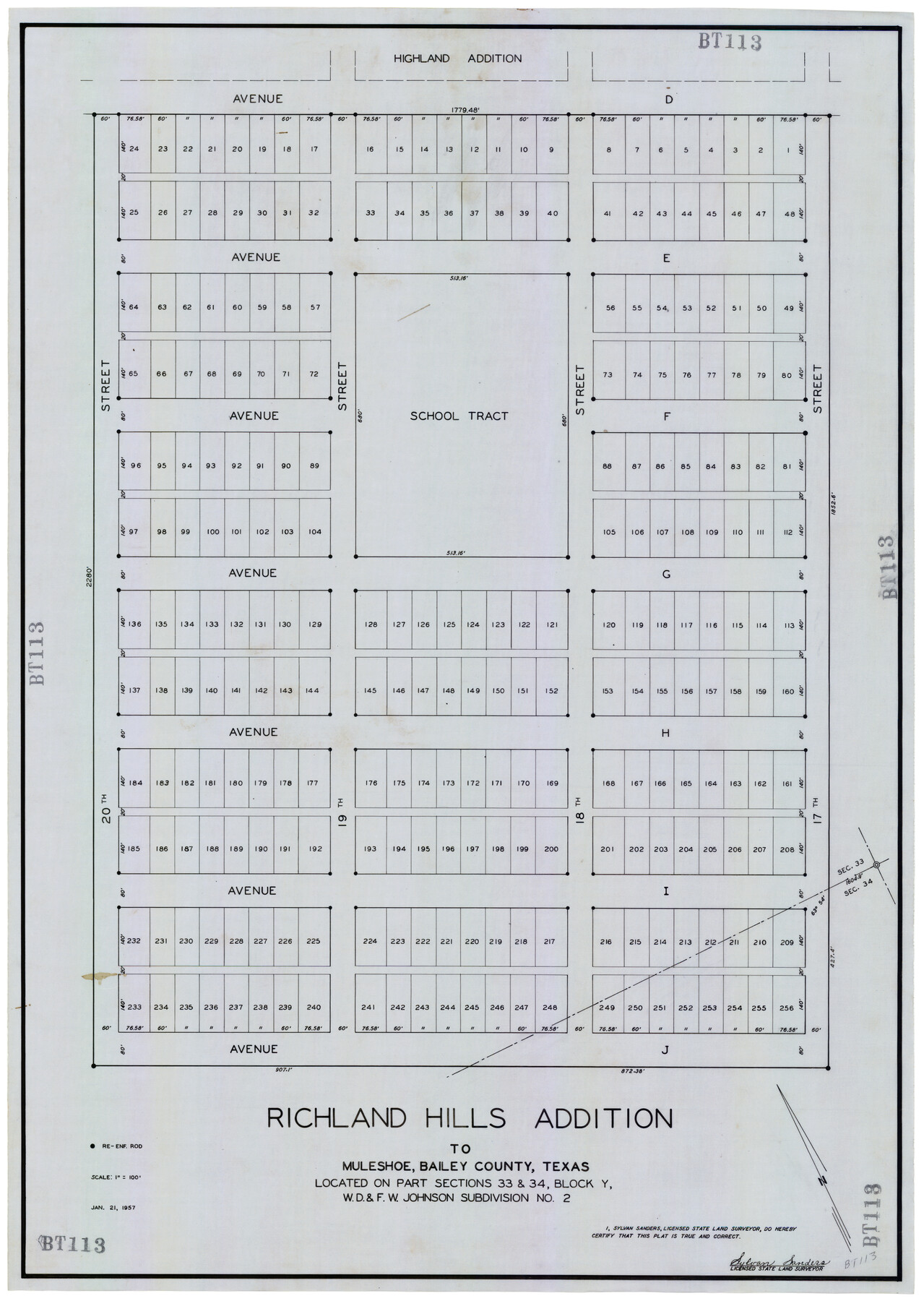
Richland Hills Addition to Muleshoe, Bailey County, Texas
BT113
-
Map/Doc
92532
-
Collection
Twichell Survey Records
-
Object Dates
1/21/1957 (Creation Date)
-
People and Organizations
Sylvan Sanders (Surveyor/Engineer)
-
Counties
Bailey
-
Height x Width
22.9 x 31.8 inches
58.2 x 80.8 cm
Part of: Twichell Survey Records
J. N. Watson Subdivision of Blocks 1, 6, 7, and 43, Lamesa, Texas

Print $20.00
- Digital $50.00
J. N. Watson Subdivision of Blocks 1, 6, 7, and 43, Lamesa, Texas
Size 11.6 x 24.8 inches
Map/Doc 92574
[In Northwest 1/4 of County in the vicinity of the John Walker Survey]
![90910, [In Northwest 1/4 of County in the vicinity of the John Walker Survey], Twichell Survey Records](https://historictexasmaps.com/wmedia_w700/maps/90910-1.tif.jpg)
Print $20.00
- Digital $50.00
[In Northwest 1/4 of County in the vicinity of the John Walker Survey]
Size 15.2 x 23.9 inches
Map/Doc 90910
Englewood Cemetery Slaton, Texas

Print $20.00
- Digital $50.00
Englewood Cemetery Slaton, Texas
1947
Size 24.4 x 35.2 inches
Map/Doc 92838
[Area along West County Line]
![90833, [Area along West County Line], Twichell Survey Records](https://historictexasmaps.com/wmedia_w700/maps/90833-2.tif.jpg)
Print $2.00
- Digital $50.00
[Area along West County Line]
Size 7.0 x 9.6 inches
Map/Doc 90833
Ownership Map SE 1/4 Lubbock County

Print $20.00
- Digital $50.00
Ownership Map SE 1/4 Lubbock County
Size 37.2 x 36.4 inches
Map/Doc 89895
Welch, Dawson County, Texas

Print $20.00
- Digital $50.00
Welch, Dawson County, Texas
Size 19.4 x 16.6 inches
Map/Doc 92592
![91467, [Block B7], Twichell Survey Records](https://historictexasmaps.com/wmedia_w700/maps/91467-1.tif.jpg)
Tascotal Mesa Quadrangle

Print $20.00
- Digital $50.00
Tascotal Mesa Quadrangle
1917
Size 17.0 x 20.7 inches
Map/Doc 90134
T and P as Surveyed January 1876, Blocks 35-36

Print $40.00
- Digital $50.00
T and P as Surveyed January 1876, Blocks 35-36
1876
Size 29.0 x 95.2 inches
Map/Doc 93184
[Capitol Leagues 661-729]
![92979, [Capitol Leagues 661-729], Twichell Survey Records](https://historictexasmaps.com/wmedia_w700/maps/92979-1.tif.jpg)
Print $20.00
- Digital $50.00
[Capitol Leagues 661-729]
Size 24.2 x 24.9 inches
Map/Doc 92979
N. C. Payne Land in Lamb and Hale Counties]
![91060, N. C. Payne Land in Lamb and Hale Counties], Twichell Survey Records](https://historictexasmaps.com/wmedia_w700/maps/91060-1.tif.jpg)
Print $20.00
- Digital $50.00
N. C. Payne Land in Lamb and Hale Counties]
Size 18.6 x 23.9 inches
Map/Doc 91060
[North part of University Lands Block 20]
![91581, [North part of University Lands Block 20], Twichell Survey Records](https://historictexasmaps.com/wmedia_w700/maps/91581-1.tif.jpg)
Print $2.00
- Digital $50.00
[North part of University Lands Block 20]
Size 10.8 x 8.3 inches
Map/Doc 91581
You may also like
Jones County Sketch File 20

Print $4.00
- Digital $50.00
Jones County Sketch File 20
1875
Size 14.2 x 8.8 inches
Map/Doc 28543
Map of the United States

Print $20.00
- Digital $50.00
Map of the United States
1851
Size 25.1 x 25.3 inches
Map/Doc 93899
Flight Mission No. DQN-7K, Frame 8, Calhoun County

Print $20.00
- Digital $50.00
Flight Mission No. DQN-7K, Frame 8, Calhoun County
1953
Size 18.5 x 22.2 inches
Map/Doc 84459
Working Sketch in Randall and Swisher Cos.

Print $20.00
- Digital $50.00
Working Sketch in Randall and Swisher Cos.
1917
Size 14.6 x 36.3 inches
Map/Doc 93048
Eastland County Working Sketch 62

Print $20.00
- Digital $50.00
Eastland County Working Sketch 62
1989
Size 20.7 x 28.0 inches
Map/Doc 68843
Webb County Sketch File 70

Print $26.00
- Digital $50.00
Webb County Sketch File 70
Size 11.4 x 8.9 inches
Map/Doc 39875
Working Sketch Armstrong County

Print $20.00
- Digital $50.00
Working Sketch Armstrong County
1909
Size 32.0 x 23.8 inches
Map/Doc 90264
Bell County Rolled Sketch 1

Print $20.00
- Digital $50.00
Bell County Rolled Sketch 1
1954
Size 38.1 x 41.1 inches
Map/Doc 75938
Stephens County Working Sketch 20

Print $20.00
- Digital $50.00
Stephens County Working Sketch 20
1972
Size 26.7 x 30.6 inches
Map/Doc 63963
Somervell County Working Sketch 6

Print $20.00
- Digital $50.00
Somervell County Working Sketch 6
1992
Size 23.2 x 21.5 inches
Map/Doc 63910

Sabine County Sketch File 6b

Print $4.00
Sabine County Sketch File 6b
1879
Size 8.1 x 9.0 inches
Map/Doc 35617