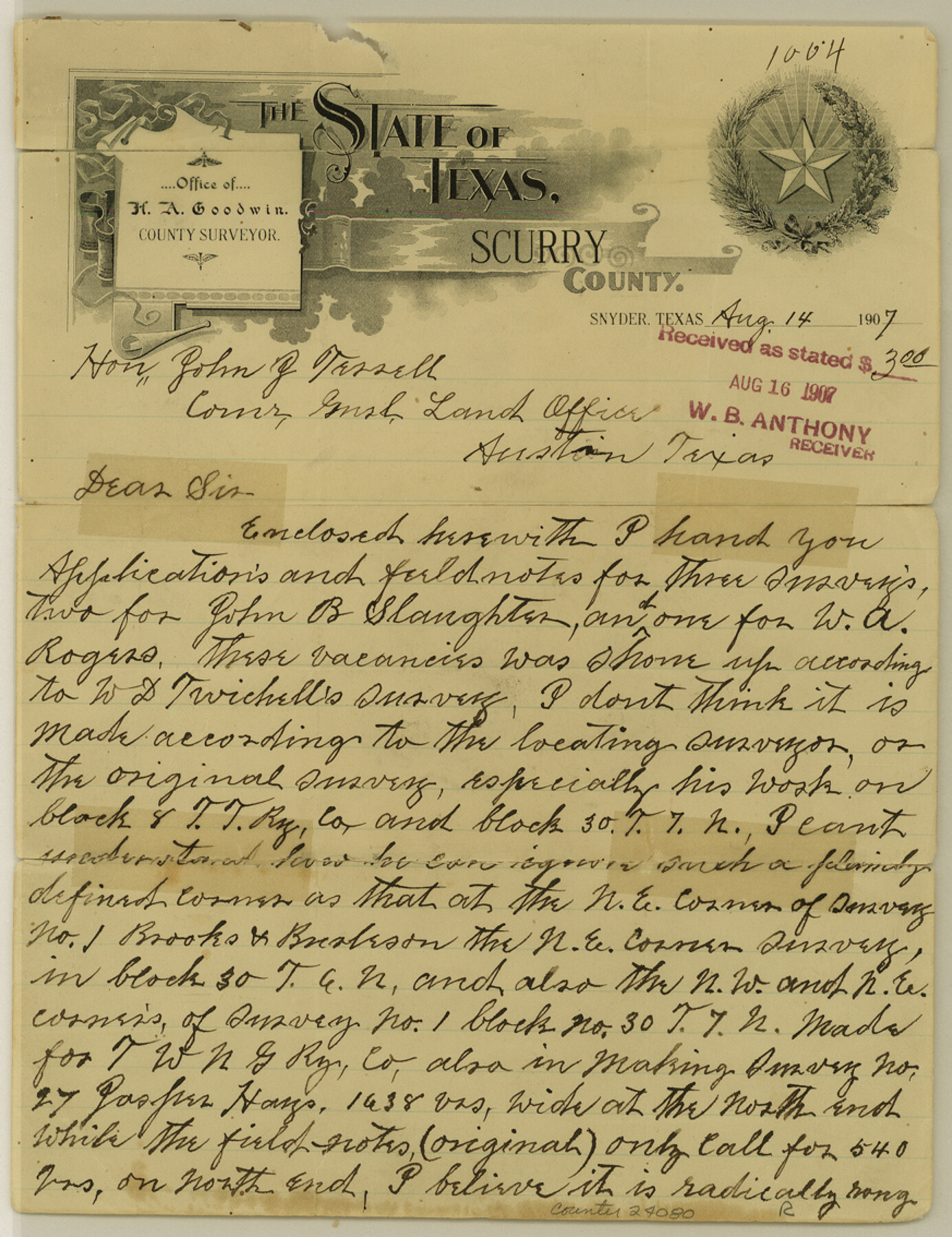
Garza County Sketch File 23
[Letter in regard to application of John B. Slaughter and W. A. Rogers]
-
Map/Doc
24080
-
Collection
General Map Collection
-
Object Dates
1907/8/14 (Creation Date)
1907/8/16 (File Date)
-
People and Organizations
Hugh A. Goodwin (Surveyor/Engineer)
W.D. Twichell (Surveyor/Engineer)
Jasper Hays (Surveyor/Engineer)
-
Counties
Garza
-
Subjects
Surveying Sketch File
-
Height x Width
11.3 x 8.7 inches
28.7 x 22.1 cm
-
Medium
paper, manuscript
-
Features
Yellow House River
Part of: General Map Collection
Starr County Rolled Sketch 20

Print $20.00
- Digital $50.00
Starr County Rolled Sketch 20
1921
Size 23.6 x 15.4 inches
Map/Doc 7804
Coryell County Working Sketch 23

Print $20.00
- Digital $50.00
Coryell County Working Sketch 23
1977
Size 27.6 x 30.6 inches
Map/Doc 68230
Jackson County Sketch File 16

Print $10.00
- Digital $50.00
Jackson County Sketch File 16
1913
Size 14.3 x 8.7 inches
Map/Doc 27668
Duval County Sketch File 54

Print $20.00
- Digital $50.00
Duval County Sketch File 54
1937
Size 19.0 x 26.4 inches
Map/Doc 11403
Presidio County Working Sketch Graphic Index, South Part, Sheet 2 (Sketches 45 to Most Recent)

Print $20.00
- Digital $50.00
Presidio County Working Sketch Graphic Index, South Part, Sheet 2 (Sketches 45 to Most Recent)
1975
Size 32.4 x 37.9 inches
Map/Doc 76671
South Part of Webb County

Print $40.00
- Digital $50.00
South Part of Webb County
1984
Size 43.5 x 63.9 inches
Map/Doc 73320
Culberson County Sketch File 18

Print $8.00
- Digital $50.00
Culberson County Sketch File 18
Size 14.3 x 8.8 inches
Map/Doc 20185
Texas Gulf Coast Map from the Sabine River to the Rio Grande as subdivided for mineral development

Print $40.00
- Digital $50.00
Texas Gulf Coast Map from the Sabine River to the Rio Grande as subdivided for mineral development
1948
Size 60.9 x 36.7 inches
Map/Doc 2909
Grayson County Boundary File 3

Print $8.00
- Digital $50.00
Grayson County Boundary File 3
Size 12.8 x 7.9 inches
Map/Doc 53941
Mason County Rolled Sketch 1

Print $20.00
- Digital $50.00
Mason County Rolled Sketch 1
1940
Size 21.2 x 24.9 inches
Map/Doc 6674
Maverick County Sketch File 1 1/2

Print $20.00
- Digital $50.00
Maverick County Sketch File 1 1/2
1875
Size 23.2 x 27.6 inches
Map/Doc 12049
Val Verde County Sketch File Z21

Print $20.00
- Digital $50.00
Val Verde County Sketch File Z21
Size 18.3 x 17.3 inches
Map/Doc 12560
You may also like
Castro County Boundary File 1 and 1a

Print $44.00
- Digital $50.00
Castro County Boundary File 1 and 1a
Size 8.9 x 9.9 inches
Map/Doc 51186
Castro County Working Sketch 8

Print $20.00
- Digital $50.00
Castro County Working Sketch 8
1979
Size 21.2 x 19.3 inches
Map/Doc 67903
Brazos Santiago, Texas

Print $20.00
- Digital $50.00
Brazos Santiago, Texas
1882
Size 9.0 x 16.9 inches
Map/Doc 97186
Briscoe County Sketch File A

Print $40.00
- Digital $50.00
Briscoe County Sketch File A
1894
Size 17.3 x 21.1 inches
Map/Doc 10997

Grimes County Sketch File 4

Print $4.00
- Digital $50.00
Grimes County Sketch File 4
1872
Size 12.7 x 8.0 inches
Map/Doc 24635
Flight Mission No. DQO-12K, Frame 35, Galveston County

Print $20.00
- Digital $50.00
Flight Mission No. DQO-12K, Frame 35, Galveston County
1952
Size 18.7 x 22.4 inches
Map/Doc 85226
Blocks 3 and 4 Capitol Syndicate Subdivision of Capitol Leagues

Print $20.00
- Digital $50.00
Blocks 3 and 4 Capitol Syndicate Subdivision of Capitol Leagues
1906
Size 17.5 x 27.4 inches
Map/Doc 90581
Intracoastal Waterway in Texas - Corpus Christi to Point Isabel including Arroyo Colorado to Mo. Pac. R.R. Bridge Near Harlingen

Print $20.00
- Digital $50.00
Intracoastal Waterway in Texas - Corpus Christi to Point Isabel including Arroyo Colorado to Mo. Pac. R.R. Bridge Near Harlingen
1934
Size 21.5 x 32.4 inches
Map/Doc 61883
Flight Mission No. BRE-1P, Frame 100, Nueces County

Print $20.00
- Digital $50.00
Flight Mission No. BRE-1P, Frame 100, Nueces County
1956
Size 18.4 x 22.1 inches
Map/Doc 86671
Flight Mission No. BRA-16M, Frame 55, Jefferson County

Print $20.00
- Digital $50.00
Flight Mission No. BRA-16M, Frame 55, Jefferson County
1953
Size 18.4 x 22.4 inches
Map/Doc 85672
[Galveston, Harrisburg & San Antonio Railway]
![64408, [Galveston, Harrisburg & San Antonio Railway], General Map Collection](https://historictexasmaps.com/wmedia_w700/maps/64408.tif.jpg)
Print $20.00
- Digital $50.00
[Galveston, Harrisburg & San Antonio Railway]
1892
Size 13.5 x 33.6 inches
Map/Doc 64408