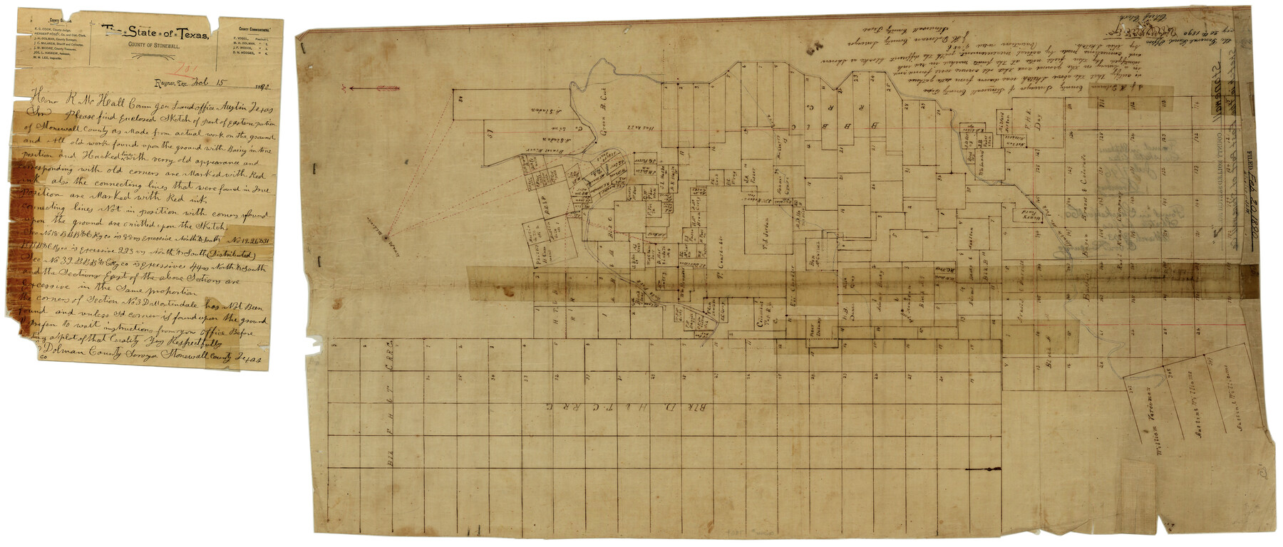
Stonewall County Rolled Sketch 7
[Sketch of area between Block D and the Brazos River]
-
Map/Doc
7864
-
Collection
General Map Collection
-
Object Dates
2/15/1890 (Creation Date)
2/20/1890 (File Date)
-
People and Organizations
J.H. Dolman (Surveyor/Engineer)
-
Counties
Stonewall
-
Subjects
Surveying Rolled Sketch
-
Height x Width
16.6 x 37.9 inches
42.2 x 96.3 cm
-
Medium
linen, manuscript
Part of: General Map Collection
Concho County Sketch File 43

Print $6.00
- Digital $50.00
Concho County Sketch File 43
1948
Size 14.4 x 8.9 inches
Map/Doc 19204
Jasper County Working Sketch 24
Print $40.00
- Digital $50.00
Jasper County Working Sketch 24
1948
Size 44.2 x 54.9 inches
Map/Doc 69651
Connected Map of Austin's Colony (1892 tracing)

Print $40.00
- Digital $50.00
Connected Map of Austin's Colony (1892 tracing)
1837
Size 90.8 x 46.7 inches
Map/Doc 93358
Donley County Working Sketch Graphic Index

Print $20.00
- Digital $50.00
Donley County Working Sketch Graphic Index
1944
Size 44.6 x 39.0 inches
Map/Doc 76526
Garza County Boundary File 3

Print $76.00
- Digital $50.00
Garza County Boundary File 3
Size 11.4 x 9.0 inches
Map/Doc 53683
[Surveys in the Bexar District along the Nueces River]
![84, [Surveys in the Bexar District along the Nueces River], General Map Collection](https://historictexasmaps.com/wmedia_w700/maps/84.tif.jpg)
Print $3.00
- Digital $50.00
[Surveys in the Bexar District along the Nueces River]
1847
Size 17.1 x 8.1 inches
Map/Doc 84
Reagan County Rolled Sketch 9

Print $20.00
- Digital $50.00
Reagan County Rolled Sketch 9
1937
Size 29.7 x 30.9 inches
Map/Doc 7437
[Sketch for Mineral Application 19144 - Pecos River Bed]
![65573, [Sketch for Mineral Application 19144 - Pecos River Bed], General Map Collection](https://historictexasmaps.com/wmedia_w700/maps/65573.tif.jpg)
Print $20.00
- Digital $50.00
[Sketch for Mineral Application 19144 - Pecos River Bed]
1927
Size 45.2 x 46.4 inches
Map/Doc 65573
Shelby County Working Sketch 1

Print $20.00
- Digital $50.00
Shelby County Working Sketch 1
1917
Size 26.2 x 30.0 inches
Map/Doc 63854

Val Verde County Boundary File 1

Print $6.00
- Digital $50.00
Val Verde County Boundary File 1
Size 14.3 x 8.7 inches
Map/Doc 59572
Flight Mission No. CRK-5P, Frame 154, Refugio County

Print $20.00
- Digital $50.00
Flight Mission No. CRK-5P, Frame 154, Refugio County
1956
Size 18.6 x 22.5 inches
Map/Doc 86935
You may also like
Madison County Working Sketch 2

Print $20.00
- Digital $50.00
Madison County Working Sketch 2
1933
Size 23.4 x 25.5 inches
Map/Doc 70764
Runnels County Sketch File 6

Print $5.00
Runnels County Sketch File 6
1872
Size 9.9 x 15.9 inches
Map/Doc 35440
Hall County Rolled Sketch 6

Print $20.00
- Digital $50.00
Hall County Rolled Sketch 6
Size 24.9 x 41.2 inches
Map/Doc 6050
Map of Texas and the country adjacent

Print $20.00
- Digital $50.00
Map of Texas and the country adjacent
1844
Size 18.3 x 26.5 inches
Map/Doc 73052
Concho County Sketch File 3

Print $6.00
- Digital $50.00
Concho County Sketch File 3
1857
Size 13.1 x 8.4 inches
Map/Doc 19124
Cherokee County Sketch File 29

Print $2.00
- Digital $50.00
Cherokee County Sketch File 29
Size 12.9 x 8.2 inches
Map/Doc 18175
Runnels County

Print $20.00
- Digital $50.00
Runnels County
1933
Size 43.7 x 31.1 inches
Map/Doc 16801
Martin County Sketch File 6

Print $4.00
- Digital $50.00
Martin County Sketch File 6
1914
Size 7.3 x 8.9 inches
Map/Doc 30642
City Leased Property in Bailey County, Texas

Print $40.00
- Digital $50.00
City Leased Property in Bailey County, Texas
1952
Size 65.9 x 42.7 inches
Map/Doc 89868
Flight Mission No. BRA-7M, Frame 73, Jefferson County

Print $20.00
- Digital $50.00
Flight Mission No. BRA-7M, Frame 73, Jefferson County
1953
Size 18.7 x 22.4 inches
Map/Doc 85495
[Surveys near Brushy Creek]
![360, [Surveys near Brushy Creek], General Map Collection](https://historictexasmaps.com/wmedia_w700/maps/360.tif.jpg)
Print $2.00
- Digital $50.00
[Surveys near Brushy Creek]
1845
Size 10.0 x 7.9 inches
Map/Doc 360
Flight Mission No. BRA-16M, Frame 93, Jefferson County

Print $20.00
- Digital $50.00
Flight Mission No. BRA-16M, Frame 93, Jefferson County
1953
Size 18.5 x 22.4 inches
Map/Doc 85705