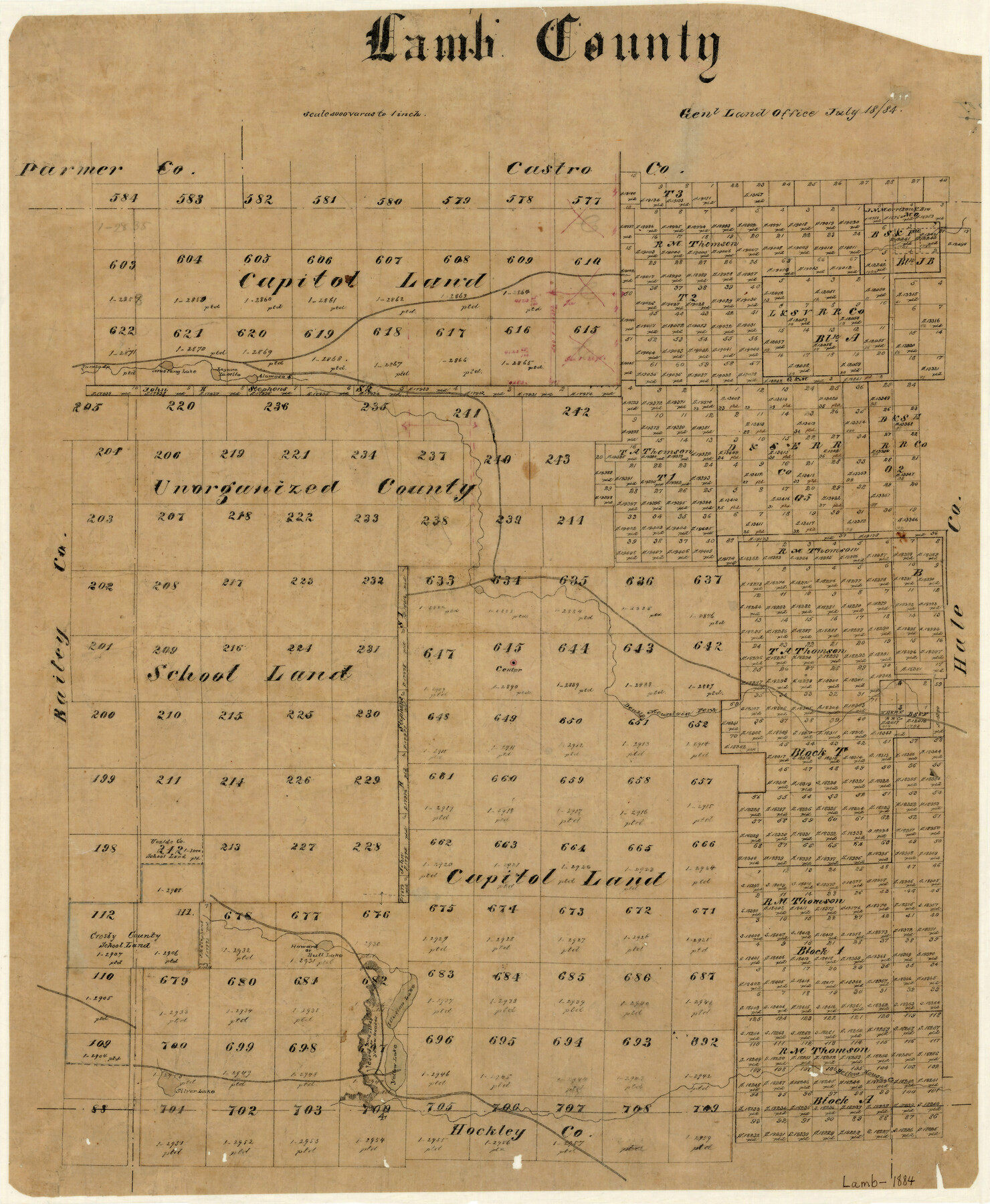
Lamb County
-
Map/Doc
3790
-
Collection
General Map Collection
-
Object Dates
7/18/1884 (Creation Date)
-
Counties
Lamb
-
Subjects
County
-
Height x Width
22.7 x 19.0 inches
57.7 x 48.3 cm
-
Features
Laguna la Mita
Alamosa Lake
Mustang Lake
Turnbo Springs
Double Mountain Fork
Howard Lake
Bull Lake
Illusion Lake
Yellow House Creek
Yellow Lake
Casas Amarillas
Yellow Houses
Silver Lake
Part of: General Map Collection
Stephens County Working Sketch 8

Print $20.00
- Digital $50.00
Stephens County Working Sketch 8
1920
Size 21.0 x 28.7 inches
Map/Doc 63951
[Surveys near Lake Soda made under G.W. Smyth, Commissioner]
![73, [Surveys near Lake Soda made under G.W. Smyth, Commissioner], General Map Collection](https://historictexasmaps.com/wmedia_w700/maps/73.tif.jpg)
Print $20.00
- Digital $50.00
[Surveys near Lake Soda made under G.W. Smyth, Commissioner]
1835
Size 16.0 x 19.3 inches
Map/Doc 73
DeWitt County Sketch File 13

Print $8.00
- Digital $50.00
DeWitt County Sketch File 13
1845
Size 12.8 x 8.2 inches
Map/Doc 20824
Flight Mission No. CGI-4N, Frame 177, Cameron County

Print $20.00
- Digital $50.00
Flight Mission No. CGI-4N, Frame 177, Cameron County
1955
Size 18.5 x 22.2 inches
Map/Doc 84680
Galveston County Sketch File 5a

Print $4.00
- Digital $50.00
Galveston County Sketch File 5a
1847
Size 12.6 x 8.2 inches
Map/Doc 23360
Flight Mission No. CRC-2R, Frame 190, Chambers County

Print $20.00
- Digital $50.00
Flight Mission No. CRC-2R, Frame 190, Chambers County
1956
Size 18.8 x 22.4 inches
Map/Doc 84768
Maps of Gulf Intracoastal Waterway, Texas - Sabine River to the Rio Grande and connecting waterways including ship channels

Print $20.00
- Digital $50.00
Maps of Gulf Intracoastal Waterway, Texas - Sabine River to the Rio Grande and connecting waterways including ship channels
1966
Size 15.6 x 22.0 inches
Map/Doc 61984
Map of the Passo Cavallo on the entrance into Matagorda Bay from the Gulf of Mexico

Print $20.00
- Digital $50.00
Map of the Passo Cavallo on the entrance into Matagorda Bay from the Gulf of Mexico
1853
Size 17.8 x 27.3 inches
Map/Doc 73012
Controlled Mosaic by Jack Amman Photogrammetric Engineers, Inc - Sheet 51

Print $20.00
- Digital $50.00
Controlled Mosaic by Jack Amman Photogrammetric Engineers, Inc - Sheet 51
1954
Size 20.0 x 24.0 inches
Map/Doc 83510

Matagorda County Working Sketch Graphic Index, Sheet 2 (Sketches 17 to Most Recent)

Print $40.00
- Digital $50.00
Matagorda County Working Sketch Graphic Index, Sheet 2 (Sketches 17 to Most Recent)
1920
Size 40.1 x 48.6 inches
Map/Doc 76634
Map of a tour from Independence to Santa Fé, Chihuahua, Monterey and Matamoros by A. Wislizenus, in 1846 and 1847
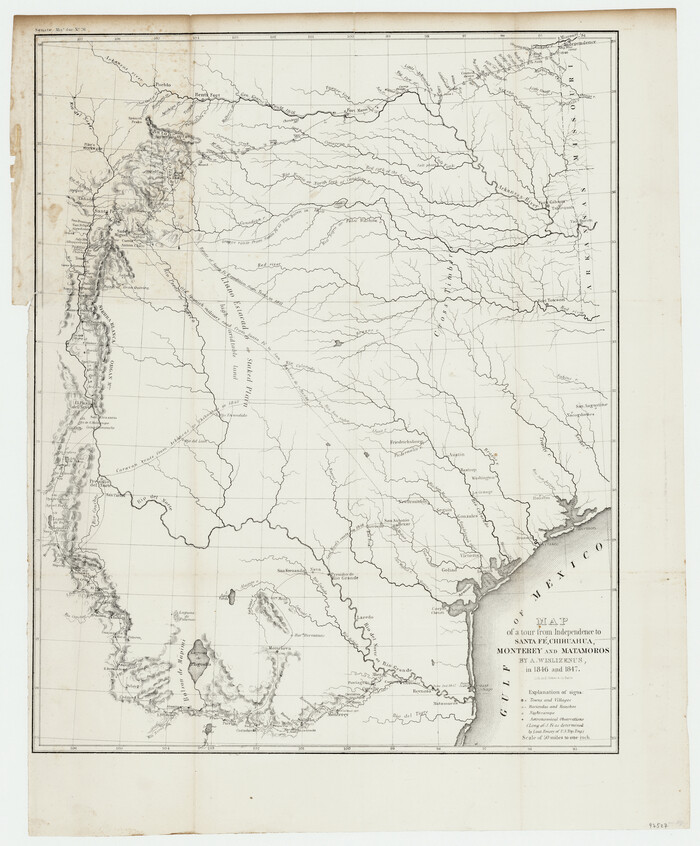
Print $20.00
- Digital $50.00
Map of a tour from Independence to Santa Fé, Chihuahua, Monterey and Matamoros by A. Wislizenus, in 1846 and 1847
1848
Size 23.2 x 19.2 inches
Map/Doc 97527
You may also like
A General Map of the Roman Empire Shewing the Situation of all its Provinces & ye Seats of ye Barbarous Nations on their Frontiers

Print $20.00
- Digital $50.00
A General Map of the Roman Empire Shewing the Situation of all its Provinces & ye Seats of ye Barbarous Nations on their Frontiers
1744
Size 10.8 x 20.5 inches
Map/Doc 96644
Montague County Sketch File 21

Print $4.00
- Digital $50.00
Montague County Sketch File 21
1888
Size 12.4 x 8.3 inches
Map/Doc 31751
Starr County Rolled Sketch 11

Print $20.00
- Digital $50.00
Starr County Rolled Sketch 11
1912
Size 16.5 x 16.4 inches
Map/Doc 7798
Jeff Davis County Rolled Sketch 17

Print $20.00
- Digital $50.00
Jeff Davis County Rolled Sketch 17
Size 28.7 x 42.2 inches
Map/Doc 6370
General Highway Map, McCulloch County, Texas

Print $20.00
General Highway Map, McCulloch County, Texas
1940
Size 24.6 x 18.2 inches
Map/Doc 79190
Dawson County Boundary File 3 (1)

Print $40.00
- Digital $50.00
Dawson County Boundary File 3 (1)
Size 11.1 x 35.8 inches
Map/Doc 52365
Borden County Working Sketch 11

Print $40.00
- Digital $50.00
Borden County Working Sketch 11
1955
Size 51.6 x 26.5 inches
Map/Doc 67471
Rio Grande from San Juan River to the Gulf of Mexico showing Boundary between the United States and Mexico

Print $20.00
- Digital $50.00
Rio Grande from San Juan River to the Gulf of Mexico showing Boundary between the United States and Mexico
1903
Size 25.6 x 15.8 inches
Map/Doc 2065
Flight Mission No. BRE-1P, Frame 136, Nueces County

Print $20.00
- Digital $50.00
Flight Mission No. BRE-1P, Frame 136, Nueces County
1956
Size 18.7 x 22.7 inches
Map/Doc 86696
![92955, [Block 4X], Twichell Survey Records](https://historictexasmaps.com/wmedia_w700/maps/92955-1.tif.jpg)
Live Oak County Sketch File 18

Print $11.00
- Digital $50.00
Live Oak County Sketch File 18
1895
Size 10.5 x 17.0 inches
Map/Doc 30284
Baylor County Rolled Sketch 5

Print $20.00
- Digital $50.00
Baylor County Rolled Sketch 5
1874
Size 43.2 x 39.7 inches
Map/Doc 8444