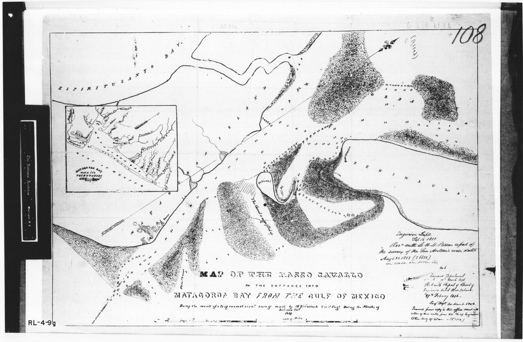
Map of the Passo Cavallo on the entrance into Matagorda Bay from the Gulf of Mexico
RL-4-9g
-
Map/Doc
73012
-
Collection
General Map Collection
-
Object Dates
1853/8/31 (Creation Date)
-
People and Organizations
U. S. Engineering Dept. (Publisher)
W.H. Stevens (Author)
W.D. Wallach (Surveyor/Engineer)
-
Subjects
Gulf of Mexico Military
-
Height x Width
17.8 x 27.3 inches
45.2 x 69.3 cm
-
Comments
B/W photostat copy from National Archives.
Part of: General Map Collection
Webb County Working Sketch 78

Print $20.00
- Digital $50.00
Webb County Working Sketch 78
1977
Size 35.0 x 42.1 inches
Map/Doc 72445
Map of Cherokee County

Print $20.00
- Digital $50.00
Map of Cherokee County
1871
Size 25.0 x 17.6 inches
Map/Doc 3388
Webb County Sketch File 71

Print $44.00
- Digital $50.00
Webb County Sketch File 71
Size 14.4 x 7.6 inches
Map/Doc 39888
Brazoria County NRC Article 33.136 Sketch 30

Print $24.00
Brazoria County NRC Article 33.136 Sketch 30
2025
Map/Doc 97475
Callahan County Working Sketch 6

Print $20.00
- Digital $50.00
Callahan County Working Sketch 6
1955
Size 30.2 x 18.8 inches
Map/Doc 67888
Yoakum County Sketch File 21

Print $2.00
- Digital $50.00
Yoakum County Sketch File 21
2005
Size 8.5 x 14.0 inches
Map/Doc 83597
Harrison County Sketch File 16

Print $20.00
- Digital $50.00
Harrison County Sketch File 16
1910
Size 41.7 x 27.5 inches
Map/Doc 10488
Karnes County Sketch File 2

Print $6.00
- Digital $50.00
Karnes County Sketch File 2
1851
Size 12.5 x 8.1 inches
Map/Doc 28547
Mexico and Guatemala

Print $20.00
- Digital $50.00
Mexico and Guatemala
1850
Size 14.6 x 17.9 inches
Map/Doc 93652

Atascosa County Working Sketch 36

Print $20.00
- Digital $50.00
Atascosa County Working Sketch 36
2008
Size 29.4 x 44.5 inches
Map/Doc 88878
Johnson County Working Sketch 15

Print $20.00
- Digital $50.00
Johnson County Working Sketch 15
1974
Size 21.6 x 23.8 inches
Map/Doc 66628
You may also like
Terry County Boundary File 1

Print $4.00
- Digital $50.00
Terry County Boundary File 1
Size 11.6 x 9.0 inches
Map/Doc 59202
Edwards County Working Sketch 55

Print $20.00
- Digital $50.00
Edwards County Working Sketch 55
1951
Size 27.1 x 21.6 inches
Map/Doc 68931
Map of Louisiana from D'Anville's Atlas

Print $20.00
- Digital $50.00
Map of Louisiana from D'Anville's Atlas
1788
Size 16.7 x 21.6 inches
Map/Doc 94111
Titus County, Texas

Print $20.00
- Digital $50.00
Titus County, Texas
1880
Size 29.4 x 22.8 inches
Map/Doc 629
Hopkins County Sketch File 4

Print $47.00
- Digital $50.00
Hopkins County Sketch File 4
Size 21.2 x 18.4 inches
Map/Doc 4565
Hutchinson County Working Sketch Graphic Index - sheet 2

Print $20.00
- Digital $50.00
Hutchinson County Working Sketch Graphic Index - sheet 2
1922
Size 43.8 x 36.7 inches
Map/Doc 76587
Culberson County Working Sketch 57

Print $40.00
- Digital $50.00
Culberson County Working Sketch 57
1974
Size 49.0 x 32.8 inches
Map/Doc 68511
Edwards County Working Sketch 122

Print $20.00
- Digital $50.00
Edwards County Working Sketch 122
1976
Size 25.8 x 33.9 inches
Map/Doc 68998
Armstrong County Sketch File A

Print $46.00
- Digital $50.00
Armstrong County Sketch File A
1902
Size 8.6 x 20.0 inches
Map/Doc 13665
The Chief Justice County of Nacogdoches. Lands in Conflict with Red River and Washington Counties

Print $20.00
The Chief Justice County of Nacogdoches. Lands in Conflict with Red River and Washington Counties
2020
Size 17.6 x 21.7 inches
Map/Doc 96064
Galveston Bay and Approaches

Print $20.00
- Digital $50.00
Galveston Bay and Approaches
1966
Size 43.3 x 32.6 inches
Map/Doc 69879
Map of Bexar County

Print $20.00
- Digital $50.00
Map of Bexar County
1845
Size 47.5 x 41.7 inches
Map/Doc 87235