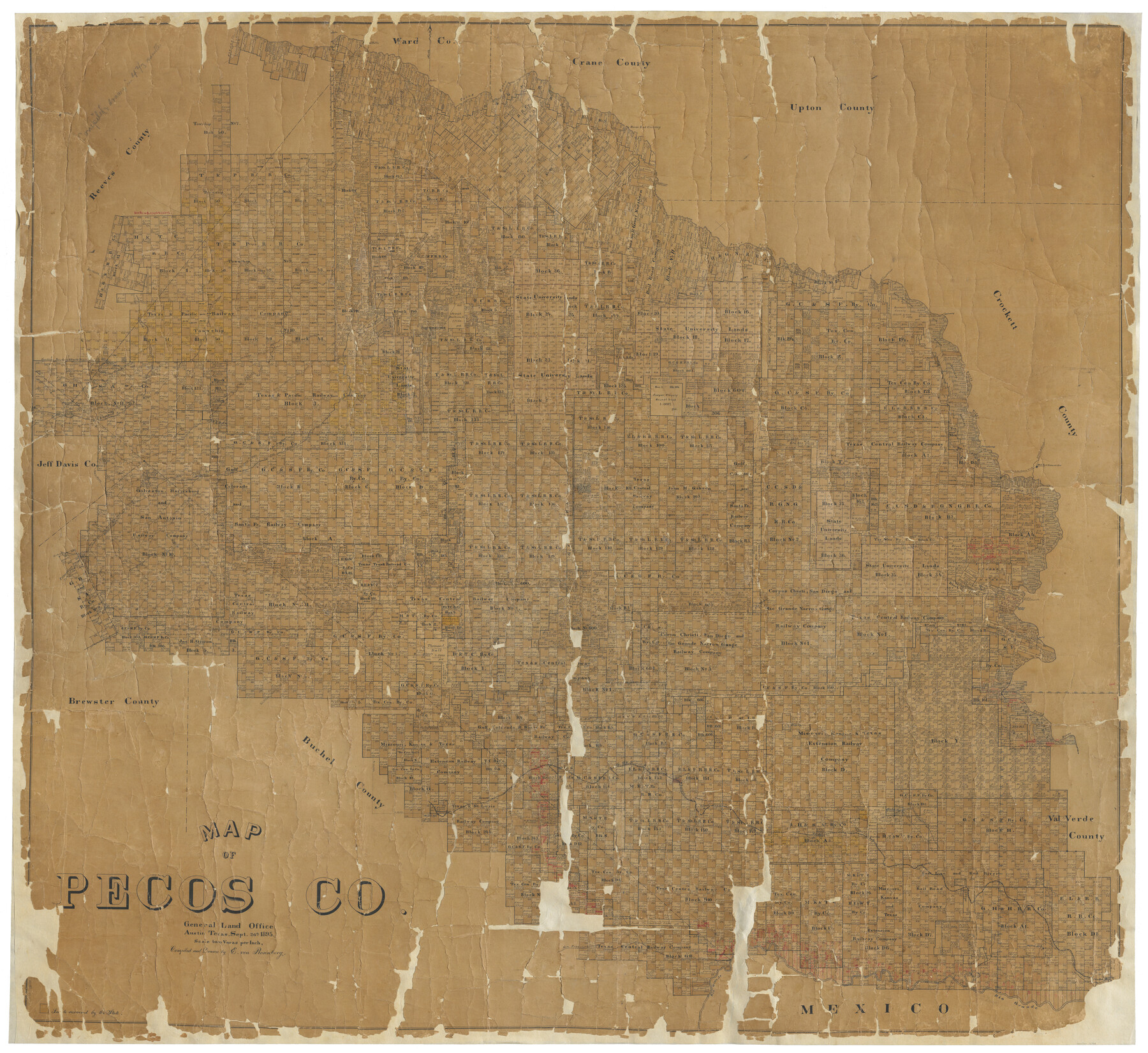
Map of Pecos County
-
Map/Doc
16788
-
Collection
General Map Collection
-
Object Dates
9/26/1895 (Creation Date)
-
People and Organizations
Texas General Land Office (Publisher)
E. von Rosenberg (Draftsman)
E. von Rosenberg (Compiler)
-
Counties
Pecos
-
Subjects
County
-
Height x Width
58.1 x 63.4 inches
147.6 x 161.0 cm
-
Comments
Conservation funded in 2004 with donation from Glen Sample Ely.
Digitized in 2012 with a generous grant from the Summerlee Foundation. -
Features
Lozier
Mouth of Independence Creek
Paisano Creek
Old Fort Lancaster
Rio Grande
Langtry
Osman
Willow Springs
Cedar Arroyo
San Francisco Creek
Richland Creek
Samuels
Watkins
Military Road
Thirston Cañon Creek
Thurston
Meyers Cañon
Painted Rocks Spring
Meyers
Lone Hill
Old El Paso Road
Old El Paso and San Antonio Road
Sheffield Post Office
Leon Cito Road
Leon Cito and Fort Stockton Road
Road to Alpine
Fort Davis
Summit of Barillo
Feodora
Saragosa Road
Saragosa and Fort Stockton Road
Toyah Road
Toyah and Fort Stockton Road
Agua Bonita Spring
Pontoon Bridge
Cedar Springs
Eldridge
Old Military Road
Leon Creek
McCutcheon
Barrillo Spring
Limpia Creek
Lone Cedar
Presidio Road
East Escondido Spring
Fort Stockton
Leon Spring
Pecos Spring
Fort Stockton Road
Fort Davis Road
Cañon Barrilla
Austin Valley
New Military Road
Monument Springs
Horse Head Crossing
Santa Rosa Spring
Peñae Colorado Road
GH&SA
Longfellow
Sanderson
Emerson
Rosenfeld
Maxon Springs
Maxon Springs
Pecos River
Road from Fort Stockton to Horse Head Crossing
Greene Mountain
Sulphur Spring
Independence Creek
Musquez Creek
Fort Lancaster
Live Oak Creek
San Antonio Road
El Paso Road
Part of: General Map Collection
Collin County Sketch File 7

Print $40.00
- Digital $50.00
Collin County Sketch File 7
1852
Size 17.3 x 14.0 inches
Map/Doc 18866
Jack County Sketch File 16a

Print $4.00
- Digital $50.00
Jack County Sketch File 16a
1885
Size 8.3 x 11.8 inches
Map/Doc 27551
Panola County Sketch File 7

Print $4.00
- Digital $50.00
Panola County Sketch File 7
Size 7.7 x 9.9 inches
Map/Doc 33457
Brewster County Sketch File 15

Print $120.00
- Digital $50.00
Brewster County Sketch File 15
1935
Size 14.2 x 8.8 inches
Map/Doc 15758
Hamilton County Sketch File 22

Print $2.00
- Digital $50.00
Hamilton County Sketch File 22
Size 6.8 x 5.5 inches
Map/Doc 24947
Lubbock County Sketch File 10

Print $4.00
- Digital $50.00
Lubbock County Sketch File 10
1914
Size 11.2 x 8.7 inches
Map/Doc 30432
Flight Mission No. DQO-2K, Frame 83, Galveston County

Print $20.00
- Digital $50.00
Flight Mission No. DQO-2K, Frame 83, Galveston County
1952
Size 18.8 x 22.5 inches
Map/Doc 85010
Galveston County NRC Article 33.136 Sketch 6

Print $20.00
- Digital $50.00
Galveston County NRC Article 33.136 Sketch 6
2001
Size 23.1 x 33.9 inches
Map/Doc 61588
Erath County Sketch File 7

Print $4.00
- Digital $50.00
Erath County Sketch File 7
Size 6.8 x 7.3 inches
Map/Doc 22267

Intracoastal Waterway in Texas - Corpus Christi to Point Isabel including Arroyo Colorado to Mo. Pac. R.R. Bridge Near Harlingen

Print $20.00
- Digital $50.00
Intracoastal Waterway in Texas - Corpus Christi to Point Isabel including Arroyo Colorado to Mo. Pac. R.R. Bridge Near Harlingen
1933
Size 28.1 x 40.8 inches
Map/Doc 61876
Rusk County Sketch File 15

Print $4.00
Rusk County Sketch File 15
1855
Size 8.1 x 10.1 inches
Map/Doc 35516
You may also like
Duval County Rolled Sketch 38

Print $20.00
- Digital $50.00
Duval County Rolled Sketch 38
1937
Size 22.6 x 16.1 inches
Map/Doc 5755
Baylor County Working Sketch 5

Print $20.00
- Digital $50.00
Baylor County Working Sketch 5
1940
Size 11.9 x 30.4 inches
Map/Doc 67290
Armstrong County Working Sketch 4

Print $20.00
- Digital $50.00
Armstrong County Working Sketch 4
1918
Size 23.9 x 32.0 inches
Map/Doc 67235
Travis County Appraisal District Plat Map 2_0502

Print $20.00
- Digital $50.00
Travis County Appraisal District Plat Map 2_0502
Size 21.4 x 26.4 inches
Map/Doc 94236
King County Working Sketch 9

Print $20.00
- Digital $50.00
King County Working Sketch 9
1955
Size 34.1 x 22.7 inches
Map/Doc 70173
Sutton County Working Sketch 68

Print $40.00
- Digital $50.00
Sutton County Working Sketch 68
1972
Size 61.2 x 37.4 inches
Map/Doc 62411
Reeves County Working Sketch 65

Print $20.00
- Digital $50.00
Reeves County Working Sketch 65
1990
Size 17.3 x 19.7 inches
Map/Doc 63508
Frio County Working Sketch 5

Print $20.00
- Digital $50.00
Frio County Working Sketch 5
1936
Size 33.9 x 23.0 inches
Map/Doc 69279
[School Land Leagues in east part of Bailey County/west part of Lamb County]
![90256, [School Land Leagues in east part of Bailey County/west part of Lamb County], Twichell Survey Records](https://historictexasmaps.com/wmedia_w700/maps/90256-1.tif.jpg)
Print $2.00
- Digital $50.00
[School Land Leagues in east part of Bailey County/west part of Lamb County]
Size 11.8 x 8.9 inches
Map/Doc 90256
Hudspeth County Sketch File 39

Print $42.00
- Digital $50.00
Hudspeth County Sketch File 39
Size 8.8 x 11.5 inches
Map/Doc 27010
La Salle County Working Sketch 10

Print $20.00
- Digital $50.00
La Salle County Working Sketch 10
1928
Size 30.6 x 20.5 inches
Map/Doc 70311
