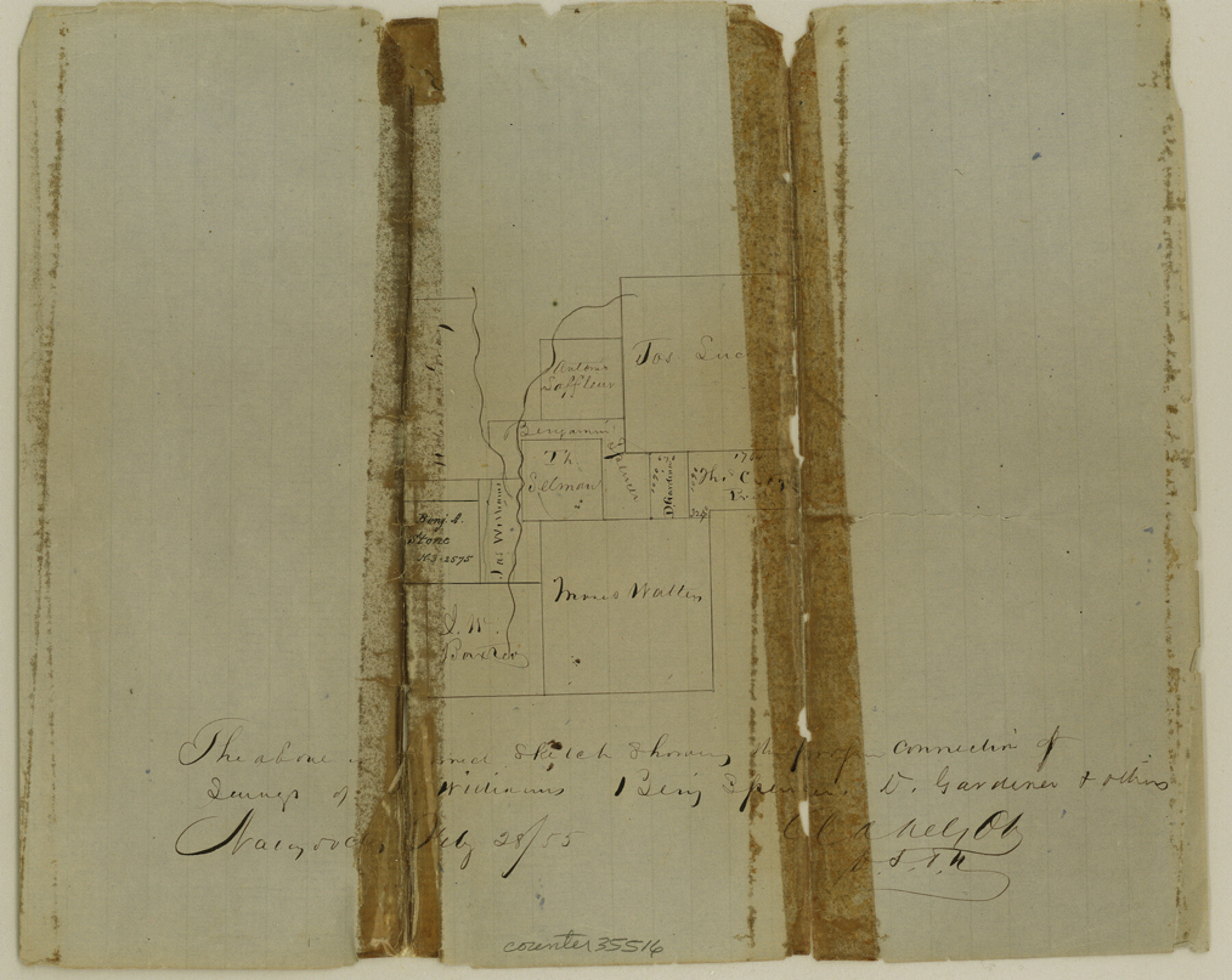
Rusk County Sketch File 15
[Sketch of area in the vicinity of the intersection of Rusk, Cherokee, and Nacogdoches Counties]
-
Map/Doc
35516
-
Collection
General Map Collection
-
Object Dates
2/28/1855 (Creation Date)
7/27/1855 (File Date)
-
People and Organizations
A.A. Nelson (Surveyor/Engineer)
-
Counties
Rusk Cherokee Nacogdoches
-
Subjects
Surveying Sketch File
-
Height x Width
8.1 x 10.1 inches
20.6 x 25.7 cm
-
Medium
paper, manuscript
Part of: General Map Collection
Galveston County Sketch File 27a

Print $23.00
- Digital $50.00
Galveston County Sketch File 27a
1899
Size 13.6 x 8.8 inches
Map/Doc 23399
[Surveys between the Sabine River and Little Cypress Creek]
![139, [Surveys between the Sabine River and Little Cypress Creek], General Map Collection](https://historictexasmaps.com/wmedia_w700/maps/139.tif.jpg)
Print $3.00
- Digital $50.00
[Surveys between the Sabine River and Little Cypress Creek]
1840
Size 9.3 x 13.0 inches
Map/Doc 139
Foard County Sketch File 33

Print $26.00
- Digital $50.00
Foard County Sketch File 33
1958
Size 11.4 x 8.9 inches
Map/Doc 22866
Cottle County Sketch File A1

Print $34.00
- Digital $50.00
Cottle County Sketch File A1
1882
Size 15.7 x 29.1 inches
Map/Doc 11199
Leon County Rolled Sketch 8

Print $97.00
- Digital $50.00
Leon County Rolled Sketch 8
1955
Size 32.5 x 31.9 inches
Map/Doc 9429
Flight Mission No. CRC-3R, Frame 50, Chambers County

Print $20.00
- Digital $50.00
Flight Mission No. CRC-3R, Frame 50, Chambers County
1956
Size 18.7 x 22.3 inches
Map/Doc 84823
Aransas County Sketch File 28

Print $16.00
- Digital $50.00
Aransas County Sketch File 28
1973
Size 11.3 x 8.8 inches
Map/Doc 13226
Van Zandt County Sketch File 30

Print $4.00
- Digital $50.00
Van Zandt County Sketch File 30
1859
Size 12.2 x 8.0 inches
Map/Doc 39461
Val Verde County Working Sketch 10

Print $20.00
- Digital $50.00
Val Verde County Working Sketch 10
1920
Size 31.7 x 21.2 inches
Map/Doc 72145
Rusk County Rolled Sketch 7

Print $20.00
- Digital $50.00
Rusk County Rolled Sketch 7
Size 43.0 x 37.3 inches
Map/Doc 9876
Map of Cameron, Hidalgo and half of Starr County of Texas

Print $20.00
- Digital $50.00
Map of Cameron, Hidalgo and half of Starr County of Texas
1942
Size 42.1 x 29.6 inches
Map/Doc 60401
Travis County Working Sketch 53

Print $40.00
- Digital $50.00
Travis County Working Sketch 53
1964
Size 42.7 x 53.0 inches
Map/Doc 69437
You may also like
Map of the State of Coahuila and Texas

Map of the State of Coahuila and Texas
1834
Size 13.3 x 14.9 inches
Map/Doc 96969
Reagan County Working Sketch Graphic Index

Print $40.00
- Digital $50.00
Reagan County Working Sketch Graphic Index
1940
Size 48.3 x 36.7 inches
Map/Doc 76677
Flight Mission No. BRA-6M, Frame 84, Jefferson County

Print $20.00
- Digital $50.00
Flight Mission No. BRA-6M, Frame 84, Jefferson County
1953
Size 18.6 x 22.4 inches
Map/Doc 85428
Liberty County Working Sketch Graphic Index - east part

Print $20.00
- Digital $50.00
Liberty County Working Sketch Graphic Index - east part
1977
Size 46.0 x 34.5 inches
Map/Doc 76620
Goliad County Rolled Sketch 7

Print $69.00
- Digital $50.00
Goliad County Rolled Sketch 7
1849
Size 10.6 x 16.1 inches
Map/Doc 45254
Midland County Working Sketch 8

Print $20.00
- Digital $50.00
Midland County Working Sketch 8
1950
Size 41.4 x 32.9 inches
Map/Doc 70988
Working Sketch in Dimmit Co.

Print $20.00
- Digital $50.00
Working Sketch in Dimmit Co.
1883
Size 14.9 x 14.6 inches
Map/Doc 436
Marion County Working Sketch 16

Print $20.00
- Digital $50.00
Marion County Working Sketch 16
1954
Size 22.6 x 25.4 inches
Map/Doc 70792
![3295, [Bell County], General Map Collection](https://historictexasmaps.com/wmedia_w700/maps/3295-1.tif.jpg)
[North line of County]
![93146, [North line of County], Twichell Survey Records](https://historictexasmaps.com/wmedia_w700/maps/93146-1.tif.jpg)
Print $40.00
- Digital $50.00
[North line of County]
Size 76.2 x 8.6 inches
Map/Doc 93146
Kleberg County Rolled Sketch 10-14

Print $20.00
- Digital $50.00
Kleberg County Rolled Sketch 10-14
1951
Size 38.0 x 33.2 inches
Map/Doc 9404
[Surveys in the Jefferson District]
![3177, [Surveys in the Jefferson District], General Map Collection](https://historictexasmaps.com/wmedia_w700/maps/3177.tif.jpg)
Print $2.00
- Digital $50.00
[Surveys in the Jefferson District]
1841
Size 9.8 x 8.0 inches
Map/Doc 3177