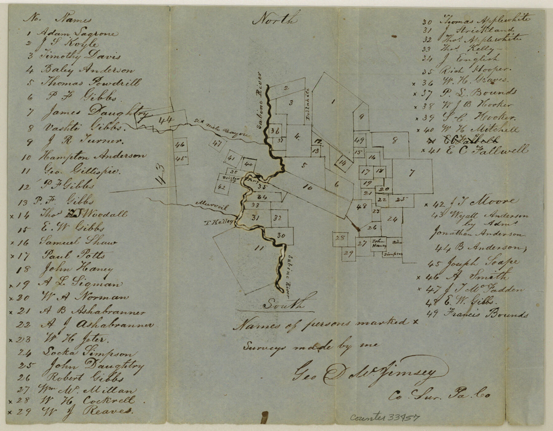
Panola County Sketch File 7
[Sketch east of Carthage along Sabine River]
-
Map/Doc
33457
-
Collection
General Map Collection
-
Object Dates
11/4/1862 (File Date)
-
People and Organizations
George D. McJimsey (Surveyor/Engineer)
-
Counties
Panola
-
Subjects
Surveying Sketch File
-
Height x Width
7.7 x 9.9 inches
19.6 x 25.2 cm
-
Medium
paper, manuscript
-
Features
Six Mile Bayou
Sabine River
Murvoil Creek
Part of: General Map Collection
Orange County Sketch File B

Print $20.00
- Digital $50.00
Orange County Sketch File B
1890
Size 17.6 x 26.0 inches
Map/Doc 12130
Galveston County Sketch File 74

Print $12.00
- Digital $50.00
Galveston County Sketch File 74
2002
Size 11.3 x 8.7 inches
Map/Doc 77526
Flight Mission No. CRC-4R, Frame 67, Chambers County

Print $20.00
- Digital $50.00
Flight Mission No. CRC-4R, Frame 67, Chambers County
1956
Size 18.8 x 22.5 inches
Map/Doc 84871
Rains County Working Sketch 10

Print $20.00
- Digital $50.00
Rains County Working Sketch 10
1998
Size 36.1 x 34.7 inches
Map/Doc 71836
Crockett County Rolled Sketch 77

Print $20.00
- Digital $50.00
Crockett County Rolled Sketch 77
1952
Size 26.9 x 28.6 inches
Map/Doc 5618
Upton County Sketch File 37

Print $6.00
- Digital $50.00
Upton County Sketch File 37
1953
Size 11.3 x 8.8 inches
Map/Doc 38900
San Augustine County Working Sketch 11a

Print $20.00
- Digital $50.00
San Augustine County Working Sketch 11a
Size 18.8 x 24.4 inches
Map/Doc 63698
[Rosebud Station Map - Tracks and Structures - Lands, San Antonio and Aransas Pass Railway Co.]
![62566, [Rosebud Station Map - Tracks and Structures - Lands, San Antonio and Aransas Pass Railway Co.], General Map Collection](https://historictexasmaps.com/wmedia_w700/maps/62566.tif.jpg)
Print $4.00
- Digital $50.00
[Rosebud Station Map - Tracks and Structures - Lands, San Antonio and Aransas Pass Railway Co.]
1919
Size 11.7 x 18.6 inches
Map/Doc 62566
Cameron County Sketch File 9

Print $26.00
- Digital $50.00
Cameron County Sketch File 9
1983
Size 11.2 x 8.3 inches
Map/Doc 17197
Map of Drum, Oyster & Bastrop Bays & vicinity in Brazoria County showing subdivision for mineral development

Print $20.00
- Digital $50.00
Map of Drum, Oyster & Bastrop Bays & vicinity in Brazoria County showing subdivision for mineral development
Size 36.8 x 47.3 inches
Map/Doc 65808
Threading the Islands: Which track fits?

Threading the Islands: Which track fits?
1986
Size 20.5 x 14.7 inches
Map/Doc 96838
Die Eisenbahm von dem Missisippi nach dem stillen Ocean (Californien)

Print $20.00
- Digital $50.00
Die Eisenbahm von dem Missisippi nach dem stillen Ocean (Californien)
1856
Size 14.0 x 14.8 inches
Map/Doc 94075
You may also like
Nacogdoches County Sketch File 17

Print $2.00
- Digital $50.00
Nacogdoches County Sketch File 17
1867
Size 15.4 x 8.7 inches
Map/Doc 32267
Starr County Rolled Sketch 41

Print $6.00
- Digital $50.00
Starr County Rolled Sketch 41
1971
Size 10.8 x 15.8 inches
Map/Doc 49030
Cooke County Sketch File 8

Print $4.00
- Digital $50.00
Cooke County Sketch File 8
Size 8.2 x 8.4 inches
Map/Doc 19235
Comal County Working Sketch Graphic Index

Print $20.00
- Digital $50.00
Comal County Working Sketch Graphic Index
1947
Size 41.8 x 35.9 inches
Map/Doc 76501
Irion County Working Sketch 4

Print $20.00
- Digital $50.00
Irion County Working Sketch 4
1925
Size 19.4 x 28.1 inches
Map/Doc 66413
Culberson County Rolled Sketch 51

Print $20.00
- Digital $50.00
Culberson County Rolled Sketch 51
1966
Size 35.2 x 27.0 inches
Map/Doc 5670

Polk County Working Sketch 38

Print $20.00
- Digital $50.00
Polk County Working Sketch 38
1975
Size 25.4 x 23.5 inches
Map/Doc 71655
Hudspeth County Working Sketch 26

Print $40.00
- Digital $50.00
Hudspeth County Working Sketch 26
1972
Size 31.5 x 54.0 inches
Map/Doc 66308
Hale County Sketch File 15

Print $20.00
- Digital $50.00
Hale County Sketch File 15
Size 22.7 x 18.6 inches
Map/Doc 11596
Map of Hale and Floyd, Lubbock and Crosby Counties

Print $40.00
- Digital $50.00
Map of Hale and Floyd, Lubbock and Crosby Counties
1892
Size 53.0 x 41.3 inches
Map/Doc 2919
Menard County Sketch File 14

Print $4.00
- Digital $50.00
Menard County Sketch File 14
1892
Size 12.8 x 8.2 inches
Map/Doc 31508