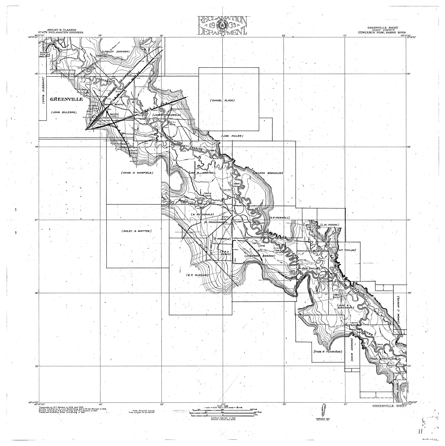
Sabine River, Greenville Sheet/Cowleach Fork of the Sabine River
-
Map/Doc
65146
-
Collection
General Map Collection
-
Object Dates
1935 (Creation Date)
-
People and Organizations
Texas State Reclamation Department (Publisher)
Eltea Armstrong (Draftsman)
Eltea Armstrong (Compiler)
Ray C. Wisdom (Surveyor/Engineer)
H.B. Armstrong (Surveyor/Engineer)
E.J. von Rosenberg (Surveyor/Engineer)
W.C. Van Wormer (Surveyor/Engineer)
-
Counties
Hunt
-
Subjects
City River Surveys Topographic
-
Height x Width
37.2 x 37.1 inches
94.5 x 94.2 cm
-
Comments
Greenville Sheet located west of the Dixon Sheet.
Part of: General Map Collection
Collin County Boundary File 3

Print $12.00
- Digital $50.00
Collin County Boundary File 3
Size 10.9 x 7.0 inches
Map/Doc 51685

Hansford County Working Sketch 4

Print $20.00
- Digital $50.00
Hansford County Working Sketch 4
1940
Size 27.6 x 25.4 inches
Map/Doc 63376

Edwards County Working Sketch 48

Print $20.00
- Digital $50.00
Edwards County Working Sketch 48
1950
Size 46.3 x 38.2 inches
Map/Doc 68924
Map of Hardin County

Print $20.00
- Digital $50.00
Map of Hardin County
1902
Size 43.1 x 44.2 inches
Map/Doc 66854
Travis County Sketch File 75

Print $2.00
- Digital $50.00
Travis County Sketch File 75
1992
Size 11.2 x 8.9 inches
Map/Doc 38473
Real County Working Sketch 91

Print $20.00
- Digital $50.00
Real County Working Sketch 91
1996
Size 22.0 x 20.0 inches
Map/Doc 71983
Flight Mission No. BRA-17M, Frame 13, Jefferson County

Print $20.00
- Digital $50.00
Flight Mission No. BRA-17M, Frame 13, Jefferson County
1953
Size 18.6 x 22.3 inches
Map/Doc 85794
Austin County Working Sketch Graphic Index

Print $20.00
- Digital $50.00
Austin County Working Sketch Graphic Index
1943
Size 38.6 x 41.1 inches
Map/Doc 76459
Cottle County Working Sketch 13

Print $20.00
- Digital $50.00
Cottle County Working Sketch 13
1960
Size 19.6 x 25.0 inches
Map/Doc 68323
Harris County Sketch File 91

Print $141.00
- Digital $50.00
Harris County Sketch File 91
1980
Size 11.3 x 8.9 inches
Map/Doc 25600
You may also like
Duval County Working Sketch 41

Print $20.00
- Digital $50.00
Duval County Working Sketch 41
1963
Size 24.1 x 22.9 inches
Map/Doc 68765
[Blocks M17, M18, M23, XO2, L, Z, and Block 47, Sections 18-25]
![91241, [Blocks M17, M18, M23, XO2, L, Z, and Block 47, Sections 18-25], Twichell Survey Records](https://historictexasmaps.com/wmedia_w700/maps/91241-1.tif.jpg)
Print $20.00
- Digital $50.00
[Blocks M17, M18, M23, XO2, L, Z, and Block 47, Sections 18-25]
Size 32.3 x 26.2 inches
Map/Doc 91241
Washington County

Print $40.00
- Digital $50.00
Washington County
1920
Size 33.5 x 48.8 inches
Map/Doc 1900
Map of Hidalgo County

Print $20.00
- Digital $50.00
Map of Hidalgo County
1896
Size 44.7 x 26.7 inches
Map/Doc 4978
Travis County Working Sketch 14

Print $20.00
- Digital $50.00
Travis County Working Sketch 14
1937
Size 26.3 x 27.2 inches
Map/Doc 69398
[Block C-41, Sections 32, 35, 35 1/2, and vicinity]
![92570, [Block C-41, Sections 32, 35, 35 1/2, and vicinity], Twichell Survey Records](https://historictexasmaps.com/wmedia_w700/maps/92570-1.tif.jpg)
Print $20.00
- Digital $50.00
[Block C-41, Sections 32, 35, 35 1/2, and vicinity]
Size 23.9 x 19.4 inches
Map/Doc 92570
Donley County Sketch File 25

Print $20.00
- Digital $50.00
Donley County Sketch File 25
Size 32.5 x 26.2 inches
Map/Doc 11369
Duval County Rolled Sketch 30

Print $20.00
- Digital $50.00
Duval County Rolled Sketch 30
1947
Size 15.8 x 27.8 inches
Map/Doc 5747
Victoria County Rolled Sketch 9

Print $20.00
- Digital $50.00
Victoria County Rolled Sketch 9
Size 24.1 x 36.2 inches
Map/Doc 95399
Cooke County Rolled Sketch 1

Print $20.00
- Digital $50.00
Cooke County Rolled Sketch 1
1940
Size 26.2 x 15.8 inches
Map/Doc 5560
Caldwell County

Print $20.00
- Digital $50.00
Caldwell County
1935
Size 37.8 x 42.0 inches
Map/Doc 73095
Jack County Sketch File 13

Print $4.00
- Digital $50.00
Jack County Sketch File 13
Size 10.3 x 8.0 inches
Map/Doc 27537