Collin County Boundary File 3
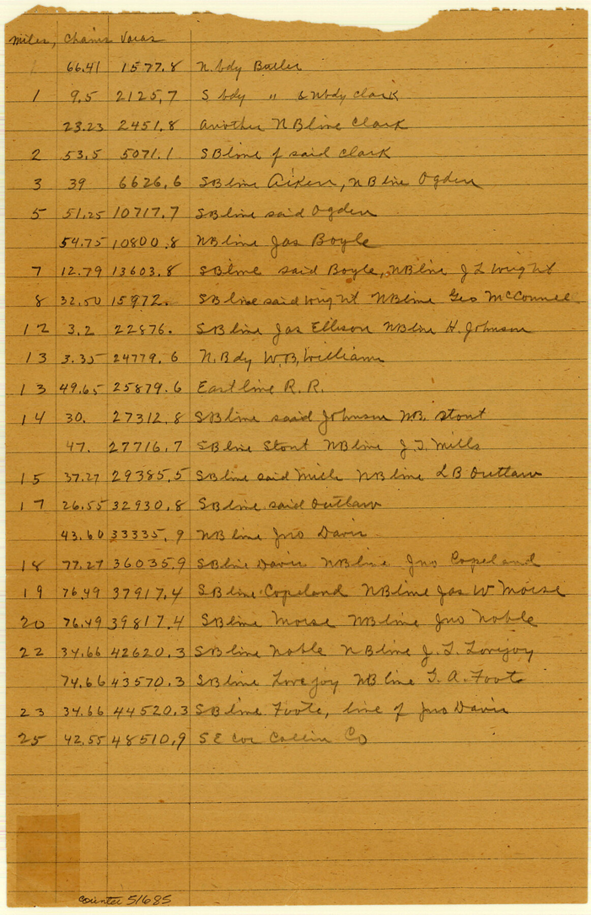
Fieldnote Description and Calcuations on the Collin County Boundary line
-
Map/Doc
51685
-
Collection
General Map Collection
-
Counties
Collin
-
Subjects
County Boundaries
-
Height x Width
10.9 x 7.0 inches
27.7 x 17.8 cm
Part of: General Map Collection
Liberty County Rolled Sketch 13

Print $20.00
- Digital $50.00
Liberty County Rolled Sketch 13
1983
Size 27.0 x 37.8 inches
Map/Doc 6619
Texas Gulf Coast Map from the Sabine River to the Rio Grande as subdivided for mineral development

Print $20.00
- Digital $50.00
Texas Gulf Coast Map from the Sabine River to the Rio Grande as subdivided for mineral development
1948
Size 45.0 x 39.9 inches
Map/Doc 2911
Pecos County Sketch File 110

Print $22.00
- Digital $50.00
Pecos County Sketch File 110
1913
Size 12.9 x 8.8 inches
Map/Doc 34041
Map of Austin's Li[ttle Colony Above the] San [Antonio Road]
![215, Map of Austin's Li[ttle Colony Above the] San [Antonio Road], General Map Collection](https://historictexasmaps.com/wmedia_w700/maps/215.tif.jpg)
Print $20.00
- Digital $50.00
Map of Austin's Li[ttle Colony Above the] San [Antonio Road]
1831
Size 14.2 x 19.3 inches
Map/Doc 215
[Val Verde County]
![63097, [Val Verde County], General Map Collection](https://historictexasmaps.com/wmedia_w700/maps/63097.tif.jpg)
Print $20.00
- Digital $50.00
[Val Verde County]
1898
Size 41.1 x 37.1 inches
Map/Doc 63097
Crane County Sketch File 18

Print $20.00
- Digital $50.00
Crane County Sketch File 18
1927
Size 15.1 x 18.4 inches
Map/Doc 11210
Harris County Working Sketch 100

Print $20.00
- Digital $50.00
Harris County Working Sketch 100
1979
Size 29.9 x 31.3 inches
Map/Doc 65992
Rand, McNally and Co.'s Texas and Indian Territory

Print $20.00
- Digital $50.00
Rand, McNally and Co.'s Texas and Indian Territory
1883
Size 24.3 x 18.6 inches
Map/Doc 4331
Ellis County Sketch File 23

Print $4.00
- Digital $50.00
Ellis County Sketch File 23
1873
Size 10.3 x 8.3 inches
Map/Doc 21881

Hemphill County Rolled Sketch 17

Print $20.00
- Digital $50.00
Hemphill County Rolled Sketch 17
1965
Size 27.8 x 36.1 inches
Map/Doc 6197
Fort Bend County Rolled Sketch 9

Print $20.00
- Digital $50.00
Fort Bend County Rolled Sketch 9
1920
Size 21.0 x 24.7 inches
Map/Doc 5899
You may also like
[Fragment, Jefferson Plotted]
![78352, [Fragment, Jefferson Plotted], General Map Collection](https://historictexasmaps.com/wmedia_w700/maps/78352.tif.jpg)
Print $2.00
- Digital $50.00
[Fragment, Jefferson Plotted]
Size 14.0 x 7.5 inches
Map/Doc 78352
Hardin County Working Sketch 29

Print $20.00
- Digital $50.00
Hardin County Working Sketch 29
1958
Size 36.7 x 22.1 inches
Map/Doc 63427
Parker County Sketch File B

Print $24.00
- Digital $50.00
Parker County Sketch File B
1858
Size 12.5 x 8.2 inches
Map/Doc 33509
Right of Way and Track Map, Texas & New Orleans R.R. Co. operated by the T. & N. O. R.R. Co., Dallas-Sabine Branch

Print $40.00
- Digital $50.00
Right of Way and Track Map, Texas & New Orleans R.R. Co. operated by the T. & N. O. R.R. Co., Dallas-Sabine Branch
1918
Size 24.6 x 56.9 inches
Map/Doc 64629
Map of Upshur County

Print $20.00
- Digital $50.00
Map of Upshur County
Size 18.5 x 23.2 inches
Map/Doc 76755
Map of Germany, Switzerland and Northern Italy engraved to illustrate Mitchell's school and family geography

Print $20.00
- Digital $50.00
Map of Germany, Switzerland and Northern Italy engraved to illustrate Mitchell's school and family geography
1840
Size 11.8 x 9.5 inches
Map/Doc 93504
Township No. 4 South Range No. 15 West of the Indian Meridian

Print $4.00
- Digital $50.00
Township No. 4 South Range No. 15 West of the Indian Meridian
1875
Size 17.9 x 22.4 inches
Map/Doc 75151
[Blocks A-23, A-26, and A-31]
![92673, [Blocks A-23, A-26, and A-31], Twichell Survey Records](https://historictexasmaps.com/wmedia_w700/maps/92673-1.tif.jpg)
Print $20.00
- Digital $50.00
[Blocks A-23, A-26, and A-31]
1954
Size 18.1 x 9.0 inches
Map/Doc 92673
Bee County Sketch File 29

Print $6.00
- Digital $50.00
Bee County Sketch File 29
1887
Size 14.0 x 8.8 inches
Map/Doc 14338
Webb County Working Sketch 11

Print $20.00
- Digital $50.00
Webb County Working Sketch 11
1921
Size 17.8 x 16.3 inches
Map/Doc 72376
[S. S. Evans surs. 1-4, Capitol Leagues 489-491 and vicinity]
![90418, [S. S. Evans surs. 1-4, Capitol Leagues 489-491 and vicinity], Twichell Survey Records](https://historictexasmaps.com/wmedia_w700/maps/90418-1.tif.jpg)
Print $20.00
- Digital $50.00
[S. S. Evans surs. 1-4, Capitol Leagues 489-491 and vicinity]
Size 21.7 x 16.9 inches
Map/Doc 90418
Parmer County Working Sketch 1

Print $20.00
- Digital $50.00
Parmer County Working Sketch 1
1903
Map/Doc 71469