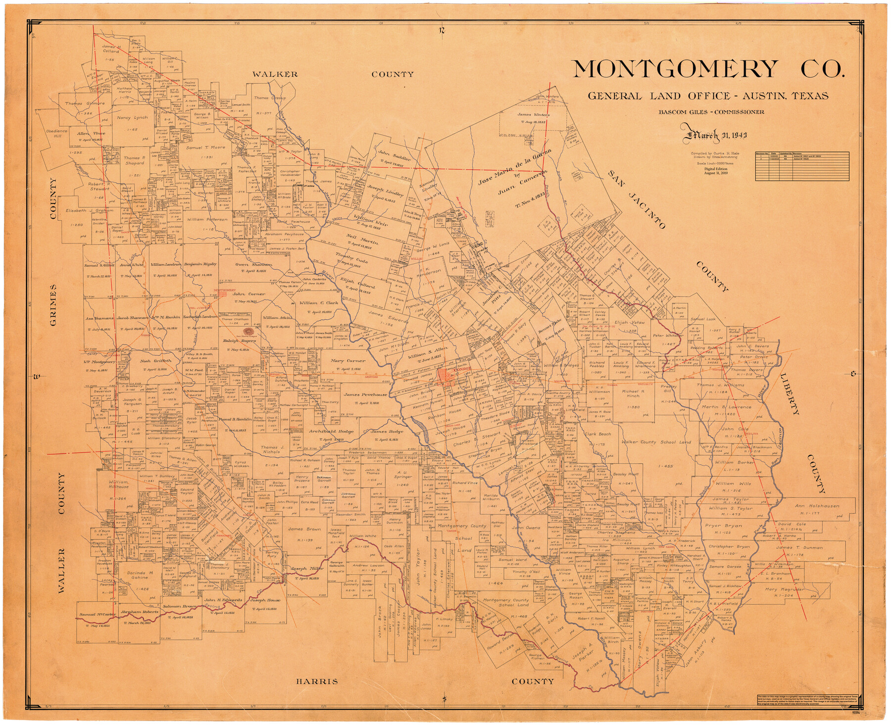
Montgomery Co.
General Land Office Official County Map
-
Map/Doc
95594
-
Collection
General Map Collection
-
Object Dates
3/31/1943 (Creation Date)
8/31/2019 (Revision Date)
12/20/2022 (Revision Date)
11/22/2024 (Revision Date)
-
People and Organizations
Kat Bird (Draftsman)
Cheyenne Betancourt (Draftsman)
Eltea Armstrong (Draftsman)
Curtis R. Hale (Compiler)
Bascom Giles (GLO Commissioner)
-
Counties
Montgomery
-
Subjects
County OCM
-
Height x Width
45.2 x 54.8 inches
114.8 x 139.2 cm
-
Medium
digital image
-
Scale
1" = 2000 varas
Part of: General Map Collection
Live Oak County Sketch File 32

Print $6.00
- Digital $50.00
Live Oak County Sketch File 32
1951
Size 11.1 x 8.6 inches
Map/Doc 30330
Comanche County Working Sketch 23

Print $20.00
- Digital $50.00
Comanche County Working Sketch 23
1974
Size 15.7 x 24.7 inches
Map/Doc 68157
Uvalde County Working Sketch 45

Print $20.00
- Digital $50.00
Uvalde County Working Sketch 45
1978
Size 18.5 x 28.2 inches
Map/Doc 72115
Liberty County Sketch File 5b

Print $6.00
- Digital $50.00
Liberty County Sketch File 5b
1857
Size 8.0 x 3.5 inches
Map/Doc 29890
Bandera County

Print $40.00
- Digital $50.00
Bandera County
1904
Size 30.7 x 61.0 inches
Map/Doc 3274
San Jacinto County Rolled Sketch 7

Print $20.00
- Digital $50.00
San Jacinto County Rolled Sketch 7
1940
Size 23.6 x 28.8 inches
Map/Doc 7558
Fort Bend County Rolled Sketch 4

Print $20.00
- Digital $50.00
Fort Bend County Rolled Sketch 4
1956
Size 30.1 x 43.8 inches
Map/Doc 5894
Duval County Sketch File 87

Print $12.00
- Digital $50.00
Duval County Sketch File 87
1991
Size 11.0 x 8.5 inches
Map/Doc 21549
McMullen County Working Sketch 12

Print $20.00
- Digital $50.00
McMullen County Working Sketch 12
1938
Size 23.4 x 26.8 inches
Map/Doc 70713
Palo Pinto County Working Sketch 17

Print $40.00
- Digital $50.00
Palo Pinto County Working Sketch 17
1974
Size 30.0 x 53.8 inches
Map/Doc 71400
Potter County Boundary File 3d

Print $12.00
- Digital $50.00
Potter County Boundary File 3d
Size 7.9 x 5.8 inches
Map/Doc 57987
Brewster County Sketch File NS-X

Print $42.00
- Digital $50.00
Brewster County Sketch File NS-X
1882
Size 20.1 x 10.5 inches
Map/Doc 15943
You may also like
Val Verde County Sketch File 11

Print $8.00
- Digital $50.00
Val Verde County Sketch File 11
1972
Size 11.3 x 8.9 inches
Map/Doc 39110
[Surveys in Austin's Colony along the Yegua River and Cedar Creek]
![67, [Surveys in Austin's Colony along the Yegua River and Cedar Creek], General Map Collection](https://historictexasmaps.com/wmedia_w700/maps/67.tif.jpg)
Print $20.00
- Digital $50.00
[Surveys in Austin's Colony along the Yegua River and Cedar Creek]
1835
Size 15.7 x 19.3 inches
Map/Doc 67
Flight Mission No. DAG-24K, Frame 158, Matagorda County

Print $20.00
- Digital $50.00
Flight Mission No. DAG-24K, Frame 158, Matagorda County
1953
Size 18.6 x 22.5 inches
Map/Doc 86572
McMullen County Sketch File 14

Print $4.00
- Digital $50.00
McMullen County Sketch File 14
1876
Size 10.0 x 8.1 inches
Map/Doc 31361
[Map of Block 97, Borden and Scurry Co (Exhibit A); Map of Southeastern part of Young Territory; Map of part of of Borden, Fisher, Kent, Mitchell, Scurry and Garza Cos. Showing the north boundary line of the T&P 80 mile reservation]
![65690, [Map of Block 97, Borden and Scurry Co (Exhibit A); Map of Southeastern part of Young Territory; Map of part of of Borden, Fisher, Kent, Mitchell, Scurry and Garza Cos. Showing the north boundary line of the T&P 80 mile reservation], General Map Collection](https://historictexasmaps.com/wmedia_w700/maps/65690-1.tif.jpg)
Print $40.00
- Digital $50.00
[Map of Block 97, Borden and Scurry Co (Exhibit A); Map of Southeastern part of Young Territory; Map of part of of Borden, Fisher, Kent, Mitchell, Scurry and Garza Cos. Showing the north boundary line of the T&P 80 mile reservation]
Size 58.7 x 42.4 inches
Map/Doc 65690
Gregg County Working Sketch 14

Print $20.00
- Digital $50.00
Gregg County Working Sketch 14
1941
Size 29.7 x 39.5 inches
Map/Doc 63281
Leon County Rolled Sketch 14A

Print $200.00
- Digital $50.00
Leon County Rolled Sketch 14A
1975
Size 16.5 x 35.5 inches
Map/Doc 46535
Webb County Rolled Sketch 5

Print $20.00
- Digital $50.00
Webb County Rolled Sketch 5
Size 43.2 x 23.0 inches
Map/Doc 8172
Garza County Sketch File 23

Print $6.00
- Digital $50.00
Garza County Sketch File 23
1907
Size 11.3 x 8.7 inches
Map/Doc 24080
Harris County Working Sketch 95

Print $20.00
- Digital $50.00
Harris County Working Sketch 95
1978
Size 26.6 x 44.1 inches
Map/Doc 65987
Lynn County Boundary File 2

Print $6.00
- Digital $50.00
Lynn County Boundary File 2
Size 11.1 x 8.7 inches
Map/Doc 56620
[Surveys in the Liberty District]
![162, [Surveys in the Liberty District], General Map Collection](https://historictexasmaps.com/wmedia_w700/maps/162.tif.jpg)
Print $2.00
- Digital $50.00
[Surveys in the Liberty District]
1841
Size 7.6 x 10.3 inches
Map/Doc 162