Dallas County Rolled Sketch 4A
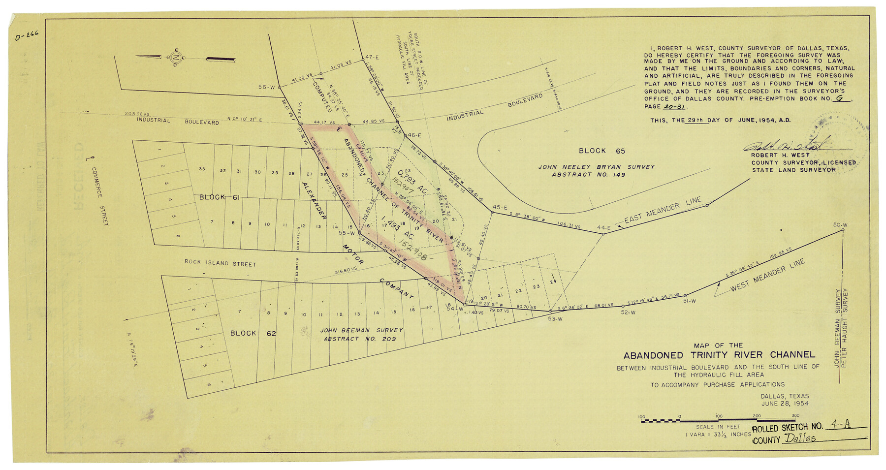
Map of the Abandoned Trinity River Channel between Industrial Boulevard and the south line of the hydraulic fill area to accompany purchase applications
-
Map/Doc
5688
-
Collection
General Map Collection
-
Object Dates
6/28/1954 (Creation Date)
7/23/1954 (File Date)
-
People and Organizations
Robert H. West (Surveyor/Engineer)
-
Counties
Dallas
-
Subjects
Surveying Rolled Sketch
-
Height x Width
12.5 x 23.1 inches
31.8 x 58.7 cm
-
Medium
blueprint/diazo
Part of: General Map Collection
Pecos County Working Sketch 141

Print $20.00
- Digital $50.00
Pecos County Working Sketch 141
1941
Size 31.8 x 42.5 inches
Map/Doc 9733
Galveston County Sketch File 33

Print $12.00
- Digital $50.00
Galveston County Sketch File 33
1934
Size 11.2 x 8.8 inches
Map/Doc 23413
Terry County Working Sketch 3

Print $40.00
- Digital $50.00
Terry County Working Sketch 3
1953
Size 125.9 x 28.4 inches
Map/Doc 62108
Leon County Working Sketch 25

Print $20.00
- Digital $50.00
Leon County Working Sketch 25
1968
Size 30.6 x 26.7 inches
Map/Doc 70424
Flight Mission No. BQR-14K, Frame 39, Brazoria County

Print $20.00
- Digital $50.00
Flight Mission No. BQR-14K, Frame 39, Brazoria County
1952
Size 18.9 x 22.6 inches
Map/Doc 84096
McClennan County Robertson District East of the Brazos Milam District West of the Brazos

Print $20.00
- Digital $50.00
McClennan County Robertson District East of the Brazos Milam District West of the Brazos
1878
Size 21.0 x 23.4 inches
Map/Doc 3865
Terrell County Sketch File 12

Print $4.00
- Digital $50.00
Terrell County Sketch File 12
1903
Size 5.7 x 8.5 inches
Map/Doc 37922
Flight Mission No. DQN-2K, Frame 127, Calhoun County

Print $20.00
- Digital $50.00
Flight Mission No. DQN-2K, Frame 127, Calhoun County
1953
Size 18.4 x 22.3 inches
Map/Doc 84301
Jones County Sketch File 19

Print $56.00
- Digital $50.00
Jones County Sketch File 19
1875
Size 11.1 x 8.6 inches
Map/Doc 28516
Sabine County Working Sketch 2

Print $3.00
- Digital $50.00
Sabine County Working Sketch 2
1906
Size 12.5 x 10.8 inches
Map/Doc 63673
Flight Mission No. DAG-21K, Frame 87, Matagorda County

Print $20.00
- Digital $50.00
Flight Mission No. DAG-21K, Frame 87, Matagorda County
1952
Size 18.5 x 22.4 inches
Map/Doc 86416
Chambers County Aerial Photograph Index Sheet 3

Print $20.00
- Digital $50.00
Chambers County Aerial Photograph Index Sheet 3
1956
Size 20.5 x 15.7 inches
Map/Doc 83684
You may also like
[Right of Way Map, Belton Branch of the M.K.&T. RR.]
![64715, [Right of Way Map, Belton Branch of the M.K.&T. RR.], General Map Collection](https://historictexasmaps.com/wmedia_w700/maps/64715-1.tif.jpg)
Print $2.00
- Digital $50.00
[Right of Way Map, Belton Branch of the M.K.&T. RR.]
1896
Size 11.1 x 8.3 inches
Map/Doc 64715
Aransas County Sketch File 38

Print $244.00
- Digital $50.00
Aransas County Sketch File 38
1996
Size 11.1 x 8.7 inches
Map/Doc 13465
Burleson County Sketch File 5

Print $4.00
- Digital $50.00
Burleson County Sketch File 5
Size 12.9 x 8.3 inches
Map/Doc 16649
Kendall County Working Sketch 11

Print $20.00
- Digital $50.00
Kendall County Working Sketch 11
1954
Size 34.0 x 24.8 inches
Map/Doc 66683
La Salle County Working Sketch 22

Print $20.00
- Digital $50.00
La Salle County Working Sketch 22
1942
Size 36.2 x 29.2 inches
Map/Doc 70323
Zavala County Sketch File 11

Print $4.00
- Digital $50.00
Zavala County Sketch File 11
1885
Size 14.4 x 8.8 inches
Map/Doc 41270
Carson County Boundary File 9

Print $74.00
- Digital $50.00
Carson County Boundary File 9
Size 9.0 x 8.9 inches
Map/Doc 51175
Nueces County Rolled Sketch 38

Print $458.00
- Digital $50.00
Nueces County Rolled Sketch 38
Size 10.1 x 16.4 inches
Map/Doc 47717
Erath County Working Sketch 50b

Print $20.00
- Digital $50.00
Erath County Working Sketch 50b
Size 43.4 x 25.8 inches
Map/Doc 69132
Pecos County Rolled Sketch 16

Print $40.00
- Digital $50.00
Pecos County Rolled Sketch 16
1882
Size 42.0 x 65.9 inches
Map/Doc 9682
Ochiltree County

Print $20.00
- Digital $50.00
Ochiltree County
1908
Size 42.6 x 37.5 inches
Map/Doc 66958
Pecos County Working Sketch 85

Print $20.00
- Digital $50.00
Pecos County Working Sketch 85
1962
Size 45.4 x 35.7 inches
Map/Doc 71557