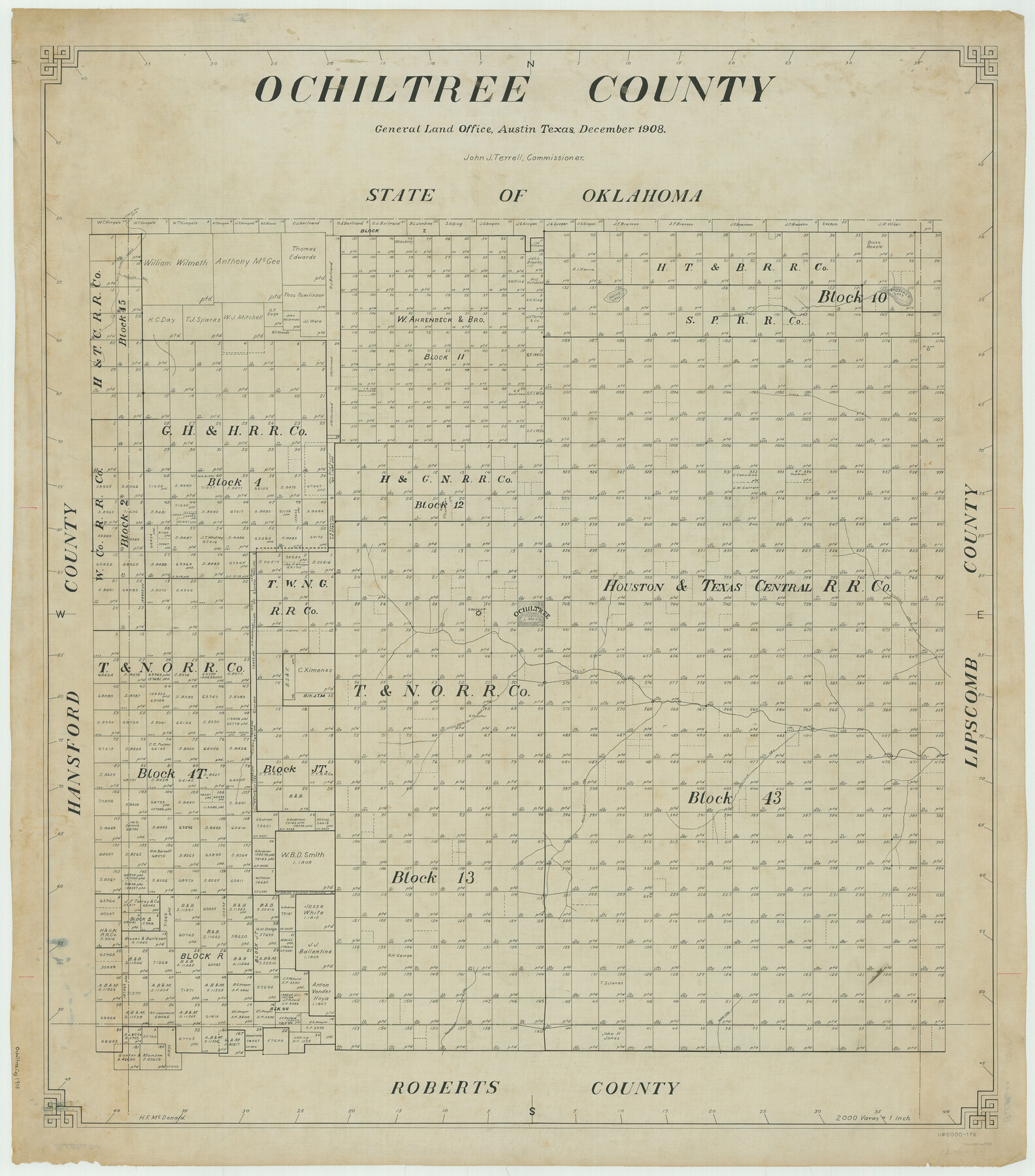
Ochiltree County
-
Map/Doc
66958
-
Collection
General Map Collection
-
Object Dates
1908 (Creation Date)
-
People and Organizations
Texas General Land Office (Publisher)
John J. Terrell (GLO Commissioner)
H.F. McDonald (Draftsman)
H.F. McDonald (Compiler)
-
Counties
Ochiltree
-
Subjects
County
-
Height x Width
42.6 x 37.5 inches
108.2 x 95.3 cm
Part of: General Map Collection
Louisiana and Texas Intracoastal Waterway

Print $20.00
- Digital $50.00
Louisiana and Texas Intracoastal Waterway
1929
Size 13.6 x 19.8 inches
Map/Doc 83345
Borden County Working Sketch 14

Print $20.00
- Digital $50.00
Borden County Working Sketch 14
1959
Size 27.8 x 25.2 inches
Map/Doc 67474
El Paso County Sketch File 41

Print $6.00
- Digital $50.00
El Paso County Sketch File 41
1994
Size 11.4 x 8.8 inches
Map/Doc 22238
Hartley County Working Sketch 2

Print $20.00
- Digital $50.00
Hartley County Working Sketch 2
1920
Size 41.8 x 30.7 inches
Map/Doc 66052
Sabine Bank to East Bay including Heald Bank

Print $20.00
- Digital $50.00
Sabine Bank to East Bay including Heald Bank
1957
Size 45.0 x 34.4 inches
Map/Doc 69846
Parker County Working Sketch 4

Print $20.00
- Digital $50.00
Parker County Working Sketch 4
1941
Map/Doc 71454
Flight Mission No. BQR-4K, Frame 59, Brazoria County

Print $20.00
- Digital $50.00
Flight Mission No. BQR-4K, Frame 59, Brazoria County
1952
Size 18.7 x 22.4 inches
Map/Doc 83992
Brewster County Working Sketch 53

Print $20.00
- Digital $50.00
Brewster County Working Sketch 53
1951
Size 32.1 x 16.5 inches
Map/Doc 67587
Yoakum County Sketch File 16

Print $20.00
- Digital $50.00
Yoakum County Sketch File 16
1939
Size 15.0 x 19.4 inches
Map/Doc 12709
Kerr County Sketch File 1a

Print $8.00
- Digital $50.00
Kerr County Sketch File 1a
Size 6.0 x 8.3 inches
Map/Doc 28846
Brewster County Sketch File NS-5

Print $22.00
- Digital $50.00
Brewster County Sketch File NS-5
Size 11.2 x 8.8 inches
Map/Doc 15983

You may also like
[Surveys in Power and Hewetson's Colony]
![2, [Surveys in Power and Hewetson's Colony], General Map Collection](https://historictexasmaps.com/wmedia_w700/maps/2.tif.jpg)
Print $20.00
- Digital $50.00
[Surveys in Power and Hewetson's Colony]
1830
Size 21.3 x 22.5 inches
Map/Doc 2
Baylor County Rolled Sketch 9A

Print $20.00
- Digital $50.00
Baylor County Rolled Sketch 9A
1892
Size 16.0 x 24.6 inches
Map/Doc 5126
Coleman County Sketch File 37

Print $4.00
- Digital $50.00
Coleman County Sketch File 37
1891
Size 11.1 x 8.4 inches
Map/Doc 18742
A.W. Hudson Crosby County RR Line

Print $40.00
- Digital $50.00
A.W. Hudson Crosby County RR Line
Size 67.8 x 42.9 inches
Map/Doc 89760
Johnson's Texas

Print $20.00
- Digital $50.00
Johnson's Texas
1866
Size 18.4 x 27.2 inches
Map/Doc 89279
San Saba County Working Sketch 8

Print $20.00
- Digital $50.00
San Saba County Working Sketch 8
1979
Size 13.3 x 17.2 inches
Map/Doc 63796
Shelby County Rolled Sketch 21

Print $20.00
- Digital $50.00
Shelby County Rolled Sketch 21
Size 17.0 x 22.3 inches
Map/Doc 93285
Flight Mission No. DQN-7K, Frame 33, Calhoun County

Print $20.00
- Digital $50.00
Flight Mission No. DQN-7K, Frame 33, Calhoun County
1953
Size 18.5 x 22.1 inches
Map/Doc 84471
Bastrop County Working Sketch 9

Print $20.00
- Digital $50.00
Bastrop County Working Sketch 9
1981
Size 44.9 x 43.7 inches
Map/Doc 67309
Hudspeth County Rolled Sketch 58

Print $20.00
- Digital $50.00
Hudspeth County Rolled Sketch 58
Size 31.4 x 32.6 inches
Map/Doc 6258
Bee County Sketch File 27

Print $8.00
- Digital $50.00
Bee County Sketch File 27
1886
Size 14.3 x 8.8 inches
Map/Doc 14331
General Highway Map, Burnet County, Texas

Print $20.00
General Highway Map, Burnet County, Texas
1961
Size 18.2 x 24.5 inches
Map/Doc 79393