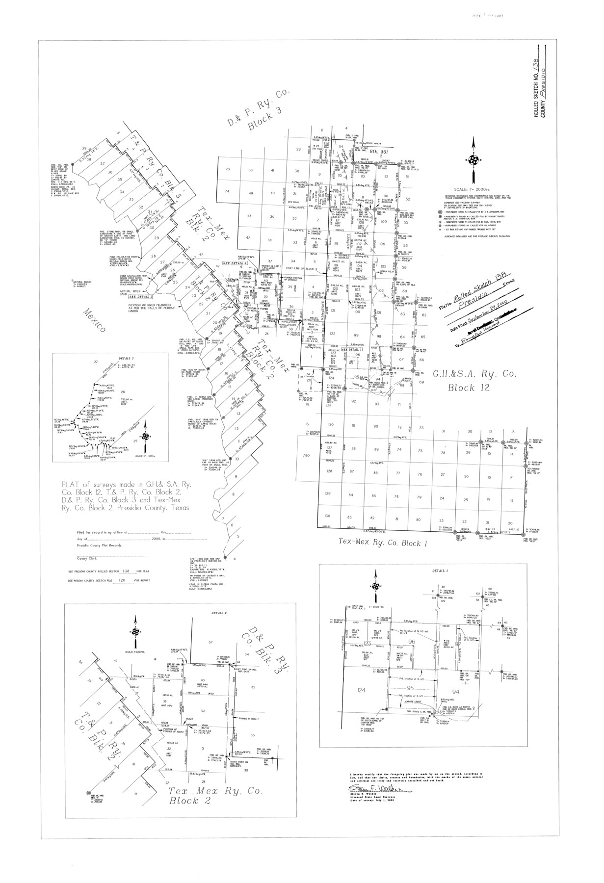
Presidio County Rolled Sketch 138
Plat of surveys made in G. H. & S. A. Ry. Co. Block 12, T. & P. Ry. Co. Block 2, D. & P. Ry. Co. Block 3, and Tex-Mex Ry. Co. Block 2, Presidio County, Texas
-
Map/Doc
7405
-
Collection
General Map Collection
-
Object Dates
2000/7/1 (Creation Date)
2000/9/29 (File Date)
-
People and Organizations
Steven F. Walker (Surveyor/Engineer)
-
Counties
Presidio
-
Subjects
Surveying Rolled Sketch
-
Height x Width
36.7 x 25.1 inches
93.2 x 63.8 cm
-
Medium
mylar, print
-
Scale
1" = 2000 varas
-
Comments
See Presidio County Rolled Sketch 139 (78647) for related sketch and see Presidio County Sketch File 120 (34934) for report.
Related maps
Presidio County Sketch File 120

Print $16.00
- Digital $50.00
Presidio County Sketch File 120
Size 14.2 x 8.8 inches
Map/Doc 34934
Presidio County Rolled Sketch 139

Print $20.00
- Digital $50.00
Presidio County Rolled Sketch 139
2002
Size 24.5 x 27.5 inches
Map/Doc 78647
Part of: General Map Collection
[Galveston, Harrisburg & San Antonio Railroad from Cuero to Stockdale]
![64191, [Galveston, Harrisburg & San Antonio Railroad from Cuero to Stockdale], General Map Collection](https://historictexasmaps.com/wmedia_w700/maps/64191.tif.jpg)
Print $20.00
- Digital $50.00
[Galveston, Harrisburg & San Antonio Railroad from Cuero to Stockdale]
1907
Size 14.2 x 34.2 inches
Map/Doc 64191
Hunt County Sketch File 2

Print $4.00
- Digital $50.00
Hunt County Sketch File 2
1857
Size 10.1 x 7.8 inches
Map/Doc 27083
Flight Mission No. DCL-7C, Frame 17, Kenedy County

Print $20.00
- Digital $50.00
Flight Mission No. DCL-7C, Frame 17, Kenedy County
1943
Size 15.3 x 15.2 inches
Map/Doc 86009
Marion County Working Sketch 34

Print $20.00
- Digital $50.00
Marion County Working Sketch 34
1983
Size 45.2 x 23.2 inches
Map/Doc 70810
Freestone County

Print $20.00
- Digital $50.00
Freestone County
1988
Size 45.8 x 42.6 inches
Map/Doc 73152
[Galveston, Harrisburg & San Antonio Railroad from Cuero to Stockdale]
![64202, [Galveston, Harrisburg & San Antonio Railroad from Cuero to Stockdale], General Map Collection](https://historictexasmaps.com/wmedia_w700/maps/64202.tif.jpg)
Print $20.00
- Digital $50.00
[Galveston, Harrisburg & San Antonio Railroad from Cuero to Stockdale]
1907
Size 13.3 x 33.1 inches
Map/Doc 64202
Caldwell County Working Sketch 7

Print $20.00
- Digital $50.00
Caldwell County Working Sketch 7
1958
Size 29.7 x 37.2 inches
Map/Doc 67837
Blanco County Sketch File 1

Print $4.00
- Digital $50.00
Blanco County Sketch File 1
1874
Size 7.8 x 7.9 inches
Map/Doc 14578
El Paso County Working Sketch 20

Print $20.00
- Digital $50.00
El Paso County Working Sketch 20
1960
Size 28.3 x 26.1 inches
Map/Doc 69042
Terry County Boundary File 4a

Print $70.00
- Digital $50.00
Terry County Boundary File 4a
Size 11.4 x 8.8 inches
Map/Doc 59249
Matagorda County Aerial Photograph Index Sheet 4

Print $20.00
- Digital $50.00
Matagorda County Aerial Photograph Index Sheet 4
1953
Size 23.6 x 19.5 inches
Map/Doc 83725
[Map of Polk County]
![4613, [Map of Polk County], General Map Collection](https://historictexasmaps.com/wmedia_w700/maps/4613-1.tif.jpg)
Print $20.00
- Digital $50.00
[Map of Polk County]
1855
Size 21.2 x 31.0 inches
Map/Doc 4613
You may also like
Evans Addition to Ropes Hockley County, Texas Situated on W. L. Ellwood's Subdivision Number 19 League 9, Donley County School Land

Print $20.00
- Digital $50.00
Evans Addition to Ropes Hockley County, Texas Situated on W. L. Ellwood's Subdivision Number 19 League 9, Donley County School Land
1923
Size 24.2 x 21.0 inches
Map/Doc 92259
Hardeman County Sketch File 13

Print $20.00
- Digital $50.00
Hardeman County Sketch File 13
Size 26.3 x 23.7 inches
Map/Doc 11625
Ward County Working Sketch 19

Print $20.00
- Digital $50.00
Ward County Working Sketch 19
1949
Size 24.2 x 26.1 inches
Map/Doc 72325
Topographical Map of the Rio Grande, Sheet No. 6

Print $20.00
- Digital $50.00
Topographical Map of the Rio Grande, Sheet No. 6
1912
Map/Doc 89530
[Blocks M8, M9, M11, W1, RC, M13, M15 and A]
![91928, [Blocks M8, M9, M11, W1, RC, M13, M15 and A], Twichell Survey Records](https://historictexasmaps.com/wmedia_w700/maps/91928-1.tif.jpg)
Print $20.00
- Digital $50.00
[Blocks M8, M9, M11, W1, RC, M13, M15 and A]
Size 17.1 x 34.2 inches
Map/Doc 91928
Hutchinson County Sketch File 43

Print $4.00
- Digital $50.00
Hutchinson County Sketch File 43
1891
Size 11.2 x 8.8 inches
Map/Doc 27309
Bee County Sketch File 8a

Print $8.00
- Digital $50.00
Bee County Sketch File 8a
1874
Size 6.0 x 7.6 inches
Map/Doc 14283
Hamilton Dam, Reservoir Clearing

Print $4.00
- Digital $50.00
Hamilton Dam, Reservoir Clearing
1936
Size 10.5 x 28.9 inches
Map/Doc 2096
Jeff Davis County Working Sketch 42

Print $20.00
- Digital $50.00
Jeff Davis County Working Sketch 42
1983
Size 42.7 x 46.7 inches
Map/Doc 66537
Goliad County Sketch File 20

Print $38.00
- Digital $50.00
Goliad County Sketch File 20
1887
Size 8.8 x 12.3 inches
Map/Doc 24265
Map of Chocolate Bay, west portion of West Bay & vicinity, Brazoria & Galveston Counties showing subdivision for mineral development

Print $40.00
- Digital $50.00
Map of Chocolate Bay, west portion of West Bay & vicinity, Brazoria & Galveston Counties showing subdivision for mineral development
Size 42.0 x 58.1 inches
Map/Doc 65806
Map of Coleman County

Print $20.00
- Digital $50.00
Map of Coleman County
1895
Size 26.1 x 18.9 inches
Map/Doc 3415