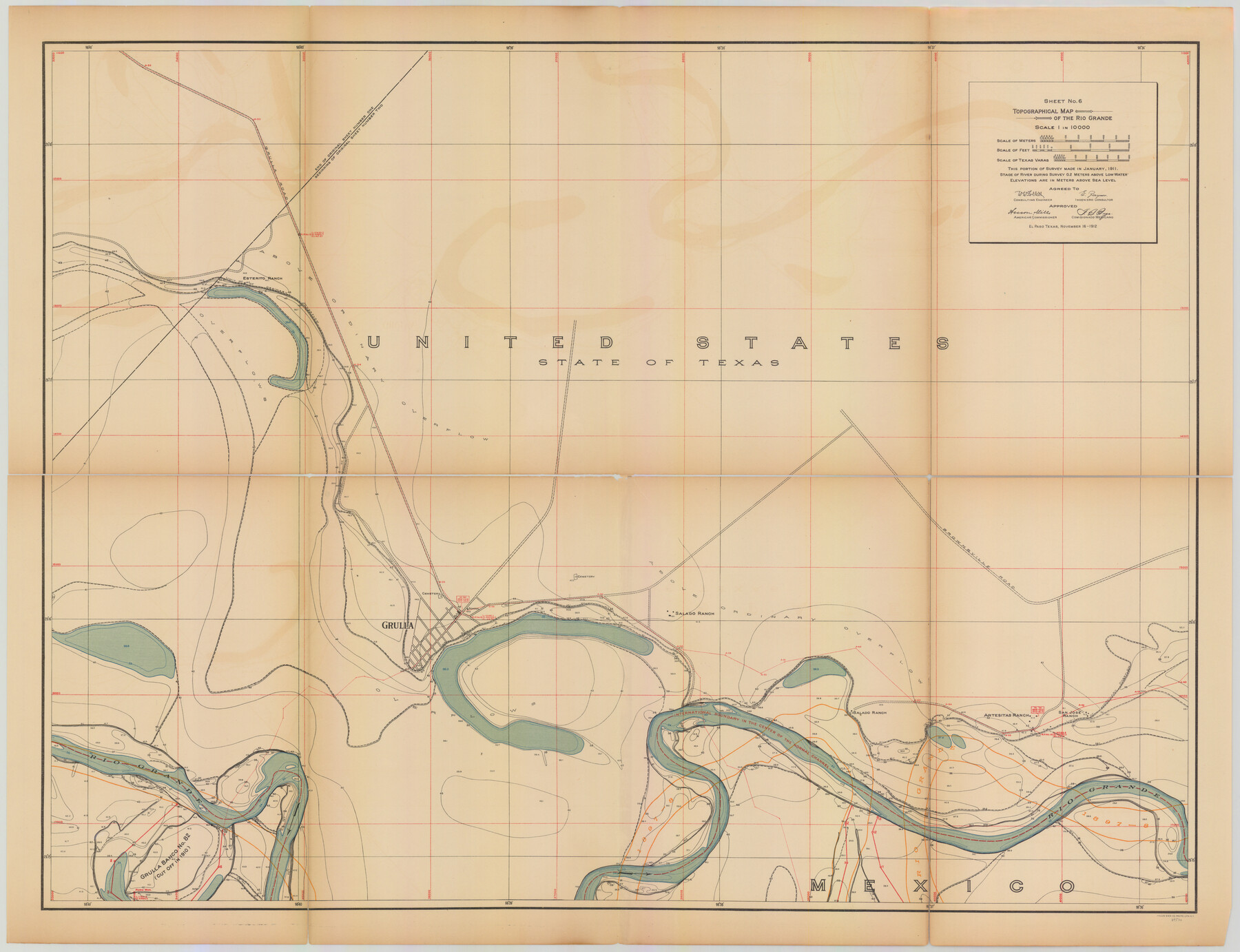
Topographical Map of the Rio Grande, Sheet No. 6
[from book: "Survey of the Rio Grande, Roma to the Gulf of Mexico, Reports and Maps"]
-
Map/Doc
89530
-
Collection
General Map Collection
-
Object Dates
1912/11/16 (Creation Date)
-
People and Organizations
International Boundary Commission (Publisher)
Anson Mills (Author)
E. Zayas (Surveyor/Engineer)
F.B. Puga (Author)
W.W. Follett (Surveyor/Engineer)
-
Subjects
River Surveys Texas Boundaries Topographic
-
Medium
paper
-
Scale
1:10000
-
Comments
This portion of the survey made in January, 1911. State of river during survey 0.2 meters above low water. Elevations are in meters above sea level. This map and 31 others were originally folded and bound into a book titled "Survey of the Rio Grande,
Part of: General Map Collection
Upshur County

Print $20.00
- Digital $50.00
Upshur County
1945
Size 39.9 x 35.3 inches
Map/Doc 95658
Pecos County Sketch File 56

Print $20.00
- Digital $50.00
Pecos County Sketch File 56
Size 35.6 x 28.6 inches
Map/Doc 10571
Brewster County Rolled Sketch 27

Print $40.00
- Digital $50.00
Brewster County Rolled Sketch 27
Size 35.1 x 48.8 inches
Map/Doc 8474
Zavala County Working Sketch 27

Print $20.00
- Digital $50.00
Zavala County Working Sketch 27
1990
Size 22.3 x 27.5 inches
Map/Doc 62102
Flight Mission No. DQO-2K, Frame 98, Galveston County

Print $20.00
- Digital $50.00
Flight Mission No. DQO-2K, Frame 98, Galveston County
1952
Size 18.9 x 22.4 inches
Map/Doc 85025
Travis County Working Sketch 28

Print $20.00
- Digital $50.00
Travis County Working Sketch 28
1955
Size 31.5 x 30.7 inches
Map/Doc 69412
Comanche County Working Sketch 3

Print $20.00
- Digital $50.00
Comanche County Working Sketch 3
1919
Size 21.9 x 12.6 inches
Map/Doc 68137
Comanche County Sketch File 27

Print $22.00
- Digital $50.00
Comanche County Sketch File 27
1912
Size 9.4 x 7.1 inches
Map/Doc 19116
Pecos County Sketch File 78

Print $6.00
- Digital $50.00
Pecos County Sketch File 78
1943
Size 11.1 x 8.8 inches
Map/Doc 33911
Flight Mission No. DAG-21K, Frame 28, Matagorda County

Print $20.00
- Digital $50.00
Flight Mission No. DAG-21K, Frame 28, Matagorda County
1952
Size 18.6 x 22.4 inches
Map/Doc 86395
Briscoe County Rolled Sketch 17

Print $20.00
- Digital $50.00
Briscoe County Rolled Sketch 17
1946
Size 36.7 x 28.7 inches
Map/Doc 5331
Real County Sketch File 12

Print $20.00
- Digital $50.00
Real County Sketch File 12
1932
Size 13.9 x 19.2 inches
Map/Doc 12231
You may also like
Menard County

Print $20.00
- Digital $50.00
Menard County
1894
Size 32.5 x 42.1 inches
Map/Doc 66926
Terrell County Working Sketch 75

Print $20.00
- Digital $50.00
Terrell County Working Sketch 75
1982
Size 41.4 x 43.7 inches
Map/Doc 69596
Lee County Working Sketch 4

Print $20.00
- Digital $50.00
Lee County Working Sketch 4
1973
Size 17.1 x 18.4 inches
Map/Doc 70383
Donley County Sketch File B3

Print $20.00
- Digital $50.00
Donley County Sketch File B3
1918
Size 22.0 x 15.0 inches
Map/Doc 11373
Hudspeth County Working Sketch 64

Print $20.00
- Digital $50.00
Hudspeth County Working Sketch 64
2006
Size 30.1 x 37.1 inches
Map/Doc 83064
Flight Mission No. DAG-24K, Frame 129, Matagorda County

Print $20.00
- Digital $50.00
Flight Mission No. DAG-24K, Frame 129, Matagorda County
1953
Size 18.5 x 22.2 inches
Map/Doc 86547
Terry County Sketch File 13

Print $20.00
- Digital $50.00
Terry County Sketch File 13
Size 43.2 x 10.2 inches
Map/Doc 10397
Flight Mission No. DQO-7K, Frame 100, Galveston County

Print $20.00
- Digital $50.00
Flight Mission No. DQO-7K, Frame 100, Galveston County
1952
Size 18.6 x 22.7 inches
Map/Doc 85115

Dallam County

Print $20.00
- Digital $50.00
Dallam County
1901
Size 42.3 x 52.4 inches
Map/Doc 16953
South Part of Brewster Co.

Print $40.00
- Digital $50.00
South Part of Brewster Co.
1955
Size 48.2 x 40.5 inches
Map/Doc 73089
McClennan County

Print $20.00
- Digital $50.00
McClennan County
1880
Size 23.6 x 25.4 inches
Map/Doc 4596