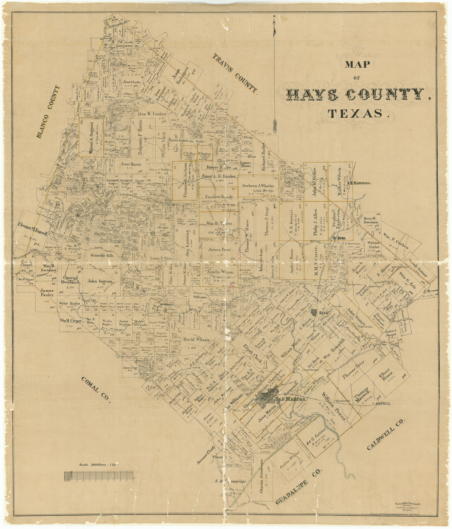
Map of Hays County, Texas
-
Map/Doc
16848
-
Collection
General Map Collection
-
Object Dates
1880 (Creation Date)
-
People and Organizations
E.A. Hausmann (Draftsman)
August Gast Bank Note & Lithograph Company (Lithographer)
-
Counties
Hays
-
Subjects
County
-
Height x Width
41.8 x 35.8 inches
106.2 x 90.9 cm
-
Scale
1" = 2000 varas
-
Comments
Conservation funded in 2002 with donation from San Marcos and Hays County Genealogical Society.
"Aug. Gast Bank Note & Litho. Company; Map Publishers, St. Louis" -
Features
Live Oak
Purgatory Road
Wimberly [sic] Road
Hemphill
High Prairie
Nacogdoches Road
San Antonio Road
Fairview
San Antonio and Nacogdoches Road
Purgatory Springs
Brushy Creek
Prairie Hill
Science Hall
Goforthville
Plum Creek
Plum Creek
Kyle
Liberty Hill
Purgatory
Purgatory Creek
San Marcos
San Marcos River
San Marcos Springs
Reidville
Jacob's Well
Maxwell
Cottonwood Creek
Hunter
Water Hole Creek
Coyote Creek
Panete Creek
Yorks Creek
MK&T
Jackson Creek
Independence Hill
Buda
Flat Creek
Dripping Springs Road
Lone Woman Mountain
Cherry Spring
Mount Sharp
Rock Springs
Lone Man Mountain
Onion Creek
Bear Creek
Manchaca
Austin Road
Dripping Springs
Austin and Blanco City Road
Barton Creek
Pedernales River
I&GN
Manchaca Springs
Halifax Creek
Blanco City Road
Bluff Springs
Blanco Road
Cypress Creek
Rio Blanco
Martin's Branch of Rio Blanco
Valley Ford
Road to Fishers Store
Hester's Run
Wimberly [sic]
Twin Sisters Mountains
Hogs Creek
Part of: General Map Collection
Scurry County

Print $20.00
- Digital $50.00
Scurry County
1921
Size 39.0 x 36.1 inches
Map/Doc 77419
Bosque County Sketch File 30

Print $6.00
- Digital $50.00
Bosque County Sketch File 30
Size 7.6 x 7.6 inches
Map/Doc 14819
Flight Mission No. DAG-22K, Frame 73, Matagorda County

Print $20.00
- Digital $50.00
Flight Mission No. DAG-22K, Frame 73, Matagorda County
1953
Size 18.7 x 22.4 inches
Map/Doc 86460
Howard County Rolled Sketch 8

Print $20.00
- Digital $50.00
Howard County Rolled Sketch 8
Size 16.8 x 40.2 inches
Map/Doc 6237
Hutchinson County Rolled Sketch 37

Print $20.00
- Digital $50.00
Hutchinson County Rolled Sketch 37
1950
Size 24.4 x 44.4 inches
Map/Doc 6296
Flight Mission No. CGI-3N, Frame 119, Cameron County

Print $20.00
- Digital $50.00
Flight Mission No. CGI-3N, Frame 119, Cameron County
1954
Size 18.5 x 22.2 inches
Map/Doc 84592
Milam County Boundary File 2a

Print $10.00
- Digital $50.00
Milam County Boundary File 2a
Size 10.6 x 8.0 inches
Map/Doc 57208
Flight Mission No. DAG-28K, Frame 24, Matagorda County

Print $20.00
- Digital $50.00
Flight Mission No. DAG-28K, Frame 24, Matagorda County
1953
Size 16.2 x 16.0 inches
Map/Doc 86592
Menard County Rolled Sketch 13

Print $20.00
- Digital $50.00
Menard County Rolled Sketch 13
1972
Size 30.8 x 24.0 inches
Map/Doc 6759
Hidalgo County Sketch File 4

Print $20.00
- Digital $50.00
Hidalgo County Sketch File 4
Size 21.4 x 25.2 inches
Map/Doc 11760
King County Boundary File 4

Print $58.00
- Digital $50.00
King County Boundary File 4
Size 14.1 x 8.7 inches
Map/Doc 64905
Flight Mission No. BRA-8M, Frame 22, Jefferson County

Print $20.00
- Digital $50.00
Flight Mission No. BRA-8M, Frame 22, Jefferson County
1953
Size 18.5 x 22.4 inches
Map/Doc 85577
You may also like
Edwards County Working Sketch 62

Print $20.00
- Digital $50.00
Edwards County Working Sketch 62
1955
Size 21.7 x 28.5 inches
Map/Doc 68938
Burnet County Rolled Sketch T

Print $20.00
- Digital $50.00
Burnet County Rolled Sketch T
Size 24.9 x 18.5 inches
Map/Doc 76053
United States Mileage Chart / United States Mileage Table / Hawaii / Alaska

United States Mileage Chart / United States Mileage Table / Hawaii / Alaska
Size 26.5 x 38.1 inches
Map/Doc 96820
San Jacinto County Rolled Sketch 4

Print $20.00
- Digital $50.00
San Jacinto County Rolled Sketch 4
Size 24.3 x 32.6 inches
Map/Doc 7557
Colorado County Rolled Sketch 5

Print $20.00
- Digital $50.00
Colorado County Rolled Sketch 5
1965
Size 37.9 x 35.9 inches
Map/Doc 8644
Presidio County Working Sketch 33

Print $40.00
- Digital $50.00
Presidio County Working Sketch 33
1947
Size 41.6 x 50.6 inches
Map/Doc 71710
Kimble County Working Sketch 96

Print $20.00
- Digital $50.00
Kimble County Working Sketch 96
1921
Size 20.9 x 26.8 inches
Map/Doc 70164
Presidio County Sketch File 38

Print $8.00
- Digital $50.00
Presidio County Sketch File 38
1911
Size 11.2 x 8.7 inches
Map/Doc 34508
Hunt County Sketch File 16a

Print $4.00
- Digital $50.00
Hunt County Sketch File 16a
Size 4.6 x 8.1 inches
Map/Doc 27109
Reagan County Rolled Sketch 29

Print $20.00
- Digital $50.00
Reagan County Rolled Sketch 29
1954
Size 35.6 x 35.4 inches
Map/Doc 9824
Roberts County Working Sketch 18

Print $20.00
- Digital $50.00
Roberts County Working Sketch 18
1975
Size 35.6 x 39.7 inches
Map/Doc 63544
Flight Mission No. DIX-7P, Frame 90, Aransas County

Print $20.00
- Digital $50.00
Flight Mission No. DIX-7P, Frame 90, Aransas County
1956
Size 18.8 x 22.4 inches
Map/Doc 83884