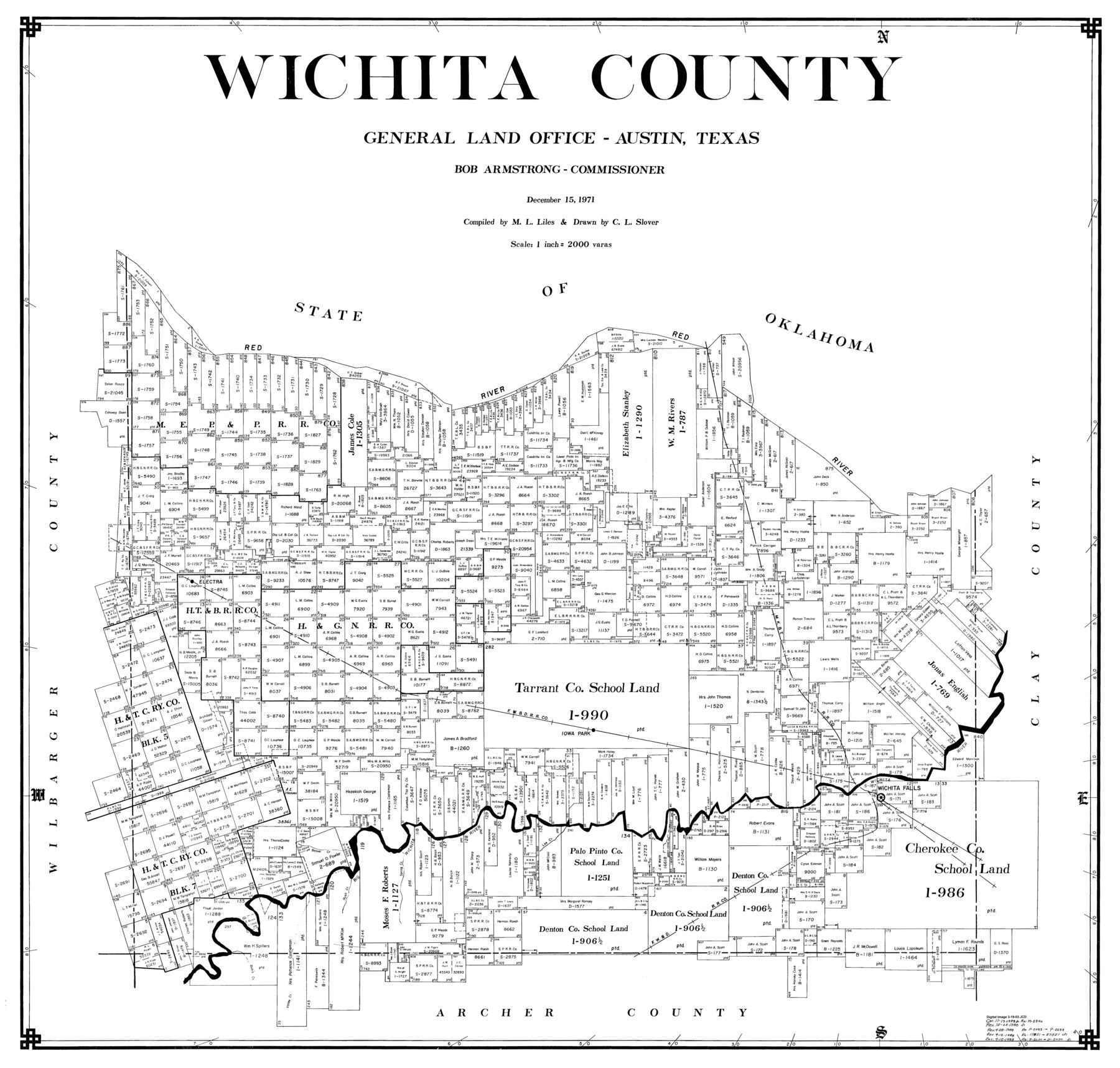
Wichita County
-
Map/Doc
77457
-
Collection
General Map Collection
-
Object Dates
12/15/1971 (Creation Date)
-
People and Organizations
M. L. Liles (Compiler)
C.L. Slover (Draftsman)
-
Counties
Wichita
-
Subjects
County
-
Height x Width
35.8 x 37.7 inches
90.9 x 95.8 cm
Part of: General Map Collection
Montgomery County Sketch File 16

Print $26.00
- Digital $50.00
Montgomery County Sketch File 16
1896
Size 14.2 x 8.8 inches
Map/Doc 31819
Smith County Rolled Sketch 6A1

Print $40.00
- Digital $50.00
Smith County Rolled Sketch 6A1
Size 49.2 x 38.6 inches
Map/Doc 10704
Zapata County Sketch File 8

Print $40.00
- Digital $50.00
Zapata County Sketch File 8
1917
Size 59.5 x 26.5 inches
Map/Doc 10438
Brown County Sketch File 3

Print $2.00
- Digital $50.00
Brown County Sketch File 3
Size 8.3 x 5.9 inches
Map/Doc 16584
La Salle County Sketch File 8

Print $20.00
- Digital $50.00
La Salle County Sketch File 8
Size 27.2 x 19.3 inches
Map/Doc 11979
Scurry County Rolled Sketch 4

Print $20.00
- Digital $50.00
Scurry County Rolled Sketch 4
Size 35.7 x 26.0 inches
Map/Doc 7765
Gregg County Rolled Sketch 21

Print $20.00
- Digital $50.00
Gregg County Rolled Sketch 21
1957
Size 34.4 x 40.4 inches
Map/Doc 10650
Glasscock County Rolled Sketch 16

Print $40.00
- Digital $50.00
Glasscock County Rolled Sketch 16
1986
Size 63.3 x 46.1 inches
Map/Doc 9060
Bosque County Sketch File 29

Print $6.00
- Digital $50.00
Bosque County Sketch File 29
1863
Size 12.9 x 8.1 inches
Map/Doc 14816
Liberty County Working Sketch 67

Print $20.00
- Digital $50.00
Liberty County Working Sketch 67
1971
Size 35.3 x 44.5 inches
Map/Doc 70527
Liberty County Working Sketch 47

Print $20.00
- Digital $50.00
Liberty County Working Sketch 47
1954
Size 28.3 x 24.6 inches
Map/Doc 70506
Stonewall County Rolled Sketch A and B

Print $20.00
- Digital $50.00
Stonewall County Rolled Sketch A and B
1886
Size 17.8 x 45.3 inches
Map/Doc 9957
You may also like
Briscoe County Rolled Sketch 20

Print $20.00
- Digital $50.00
Briscoe County Rolled Sketch 20
1949
Size 37.4 x 21.7 inches
Map/Doc 5334
Flight Mission No. CGI-3N, Frame 47, Cameron County

Print $20.00
- Digital $50.00
Flight Mission No. CGI-3N, Frame 47, Cameron County
1954
Size 18.7 x 22.3 inches
Map/Doc 84553
[Gulf, Colorado & Santa Fe]
![64573, [Gulf, Colorado & Santa Fe], General Map Collection](https://historictexasmaps.com/wmedia_w700/maps/64573-1.tif.jpg)
Print $40.00
- Digital $50.00
[Gulf, Colorado & Santa Fe]
Size 32.5 x 122.6 inches
Map/Doc 64573
Henderson County Working Sketch 11

Print $20.00
- Digital $50.00
Henderson County Working Sketch 11
1914
Size 20.7 x 22.5 inches
Map/Doc 66144
Sabine County

Print $20.00
- Digital $50.00
Sabine County
1920
Size 45.7 x 36.1 inches
Map/Doc 95631
[Map of Texas and Pacific Blocks from Brazos River westward through Palo Pinto, Stephens, Shackelford, Jones, Callahan, Taylor, Fisher, Nolan and Mitchell Counties]
![93456, [Map of Texas and Pacific Blocks from Brazos River westward through Palo Pinto, Stephens, Shackelford, Jones, Callahan, Taylor, Fisher, Nolan and Mitchell Counties], General Map Collection](https://historictexasmaps.com/wmedia_w700/maps/93456-1.tif.jpg)
Print $20.00
- Digital $50.00
[Map of Texas and Pacific Blocks from Brazos River westward through Palo Pinto, Stephens, Shackelford, Jones, Callahan, Taylor, Fisher, Nolan and Mitchell Counties]
Size 22.0 x 18.5 inches
Map/Doc 93456
Flight Mission No. CRC-3R, Frame 49, Chambers County

Print $20.00
- Digital $50.00
Flight Mission No. CRC-3R, Frame 49, Chambers County
1956
Size 18.6 x 22.3 inches
Map/Doc 84822
Kinney County Working Sketch 45

Print $20.00
- Digital $50.00
Kinney County Working Sketch 45
1978
Size 28.6 x 26.5 inches
Map/Doc 70227
Fayette County Boundary File 7

Print $40.00
- Digital $50.00
Fayette County Boundary File 7
Size 18.1 x 13.1 inches
Map/Doc 53400
Briscoe County Working Sketch 3

Print $20.00
- Digital $50.00
Briscoe County Working Sketch 3
1916
Size 28.1 x 22.0 inches
Map/Doc 67806
Flight Mission No. DQN-6K, Frame 9, Calhoun County

Print $20.00
- Digital $50.00
Flight Mission No. DQN-6K, Frame 9, Calhoun County
1953
Size 18.5 x 22.1 inches
Map/Doc 84431
El Paso County State Real Property Sketch 3

Print $20.00
- Digital $50.00
El Paso County State Real Property Sketch 3
2012
Size 25.1 x 36.4 inches
Map/Doc 93700