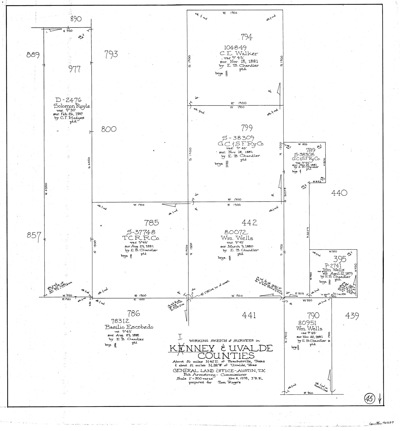
Kinney County Working Sketch 45
-
Map/Doc
70227
-
Collection
General Map Collection
-
Object Dates
11/8/1978 (Creation Date)
-
People and Organizations
Joan Kilpatrick (Draftsman)
-
Counties
Kinney Uvalde
-
Subjects
Surveying Working Sketch
-
Height x Width
28.6 x 26.5 inches
72.6 x 67.3 cm
-
Scale
1" = 300 varas
Part of: General Map Collection
Brewster County Sketch File N-22

Print $40.00
- Digital $50.00
Brewster County Sketch File N-22
Size 12.4 x 21.4 inches
Map/Doc 10969
Coke County Boundary File 1

Print $50.00
- Digital $50.00
Coke County Boundary File 1
Size 8.9 x 4.0 inches
Map/Doc 51570
Delta County Sketch File 6

Print $20.00
- Digital $50.00
Delta County Sketch File 6
Size 18.3 x 22.4 inches
Map/Doc 11310
Borden County Sketch File 1

Print $6.00
- Digital $50.00
Borden County Sketch File 1
Size 16.2 x 11.0 inches
Map/Doc 14701
[Missouri, Kansas & Texas Line Map through Bastrop County]
![64031, [Missouri, Kansas & Texas Line Map through Bastrop County], General Map Collection](https://historictexasmaps.com/wmedia_w700/maps/64031.tif.jpg)
Print $40.00
- Digital $50.00
[Missouri, Kansas & Texas Line Map through Bastrop County]
1916
Size 26.5 x 124.4 inches
Map/Doc 64031
Colorado County Rolled Sketch 5

Print $20.00
- Digital $50.00
Colorado County Rolled Sketch 5
1965
Size 37.9 x 35.9 inches
Map/Doc 8644
Uvalde County Sketch File 12A

Print $20.00
- Digital $50.00
Uvalde County Sketch File 12A
1887
Size 19.2 x 30.0 inches
Map/Doc 12527
Mapa de los Estados Unidos Mejicanos arreglado a la distribucion que en diversos decretos ha hecho del territorio el Congreso General Mejicano

Print $20.00
- Digital $50.00
Mapa de los Estados Unidos Mejicanos arreglado a la distribucion que en diversos decretos ha hecho del territorio el Congreso General Mejicano
1851
Size 24.6 x 30.3 inches
Map/Doc 96514
Harrisburg, Texas

Print $20.00
- Digital $50.00
Harrisburg, Texas
1854
Size 39.4 x 25.7 inches
Map/Doc 3044
Flight Mission No. BRA-7M, Frame 76, Jefferson County

Print $20.00
- Digital $50.00
Flight Mission No. BRA-7M, Frame 76, Jefferson County
1953
Size 18.8 x 22.3 inches
Map/Doc 85498
Upton County Sketch File 1

Print $40.00
- Digital $50.00
Upton County Sketch File 1
1881
Size 24.1 x 65.4 inches
Map/Doc 10412
San Augustine Co.

Print $20.00
- Digital $50.00
San Augustine Co.
1949
Size 45.7 x 28.6 inches
Map/Doc 77414
You may also like
Travis County Sketch File 13

Print $4.00
- Digital $50.00
Travis County Sketch File 13
1858
Size 8.2 x 6.5 inches
Map/Doc 38306
Cameron County Sketch File 7a

Print $32.00
- Digital $50.00
Cameron County Sketch File 7a
1982
Size 11.2 x 8.4 inches
Map/Doc 17115
Flight Mission No. DQN-3K, Frame 75, Calhoun County

Print $20.00
- Digital $50.00
Flight Mission No. DQN-3K, Frame 75, Calhoun County
1953
Size 18.6 x 22.4 inches
Map/Doc 84366
[Part of H. & G. N. Blocks 11 and 12]
![91565, [Part of H. & G. N. Blocks 11 and 12], Twichell Survey Records](https://historictexasmaps.com/wmedia_w700/maps/91565-1.tif.jpg)
Print $20.00
- Digital $50.00
[Part of H. & G. N. Blocks 11 and 12]
Size 21.5 x 16.7 inches
Map/Doc 91565
General Highway Map, Hale County, Texas

Print $20.00
- Digital $50.00
General Highway Map, Hale County, Texas
1949
Size 18.8 x 25.9 inches
Map/Doc 92661
Floyd County Sketch File 9a

Print $4.00
- Digital $50.00
Floyd County Sketch File 9a
1912
Size 14.5 x 8.9 inches
Map/Doc 22699
Terry County Sketch File 6

Print $8.00
- Digital $50.00
Terry County Sketch File 6
1924
Size 11.2 x 8.7 inches
Map/Doc 38026
Tyler County Sketch File 15

Print $6.00
- Digital $50.00
Tyler County Sketch File 15
1857
Size 10.4 x 7.5 inches
Map/Doc 38658
[Township 3 North, Blocks 33 and 34, T. & P. RR. Company; Township 4 North, Block 33, T. & P. RR. Company]
![92564, [Township 3 North, Blocks 33 and 34, T. & P. RR. Company; Township 4 North, Block 33, T. & P. RR. Company], Twichell Survey Records](https://historictexasmaps.com/wmedia_w700/maps/92564-1.tif.jpg)
Print $20.00
- Digital $50.00
[Township 3 North, Blocks 33 and 34, T. & P. RR. Company; Township 4 North, Block 33, T. & P. RR. Company]
1911
Size 18.6 x 24.8 inches
Map/Doc 92564
Map of Texas and the Countries Adjacent

Map of Texas and the Countries Adjacent
1844
Size 19.0 x 29.6 inches
Map/Doc 94561
Gonzales County Working Sketch 10

Print $20.00
- Digital $50.00
Gonzales County Working Sketch 10
1981
Size 18.9 x 14.7 inches
Map/Doc 63226
Austin Map and Street Guide [Recto]
![94162, Austin Map and Street Guide [Recto], General Map Collection](https://historictexasmaps.com/wmedia_w700/maps/94162.tif.jpg)
Austin Map and Street Guide [Recto]
1976
Size 35.4 x 22.7 inches
Map/Doc 94162