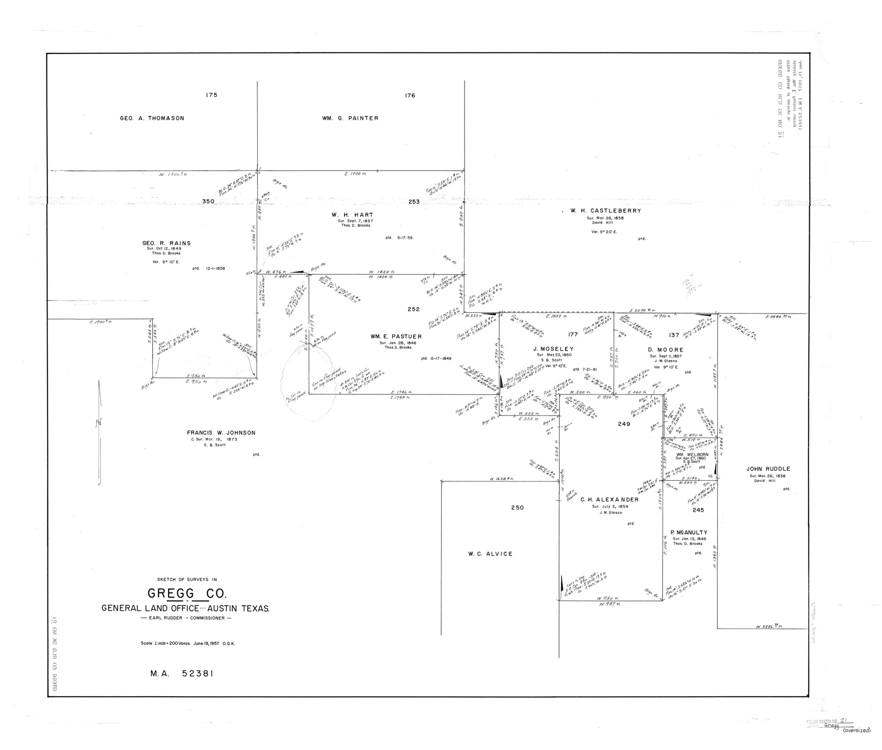
Gregg County Rolled Sketch 21
Sketch of surveys in Gregg Co. - MA 52381
-
Map/Doc
10650
-
Collection
General Map Collection
-
Object Dates
1957/6/19 (Creation Date)
1957/8/7 (File Date)
-
Counties
Gregg
-
Subjects
Surveying Rolled Sketch
-
Height x Width
34.4 x 40.4 inches
87.4 x 102.6 cm
-
Scale
1" = 200 varas
Part of: General Map Collection
Starr County Sketch File 8

Print $7.00
- Digital $50.00
Starr County Sketch File 8
Size 10.1 x 12.4 inches
Map/Doc 36858
Flight Mission No. CUG-2P, Frame 61, Kleberg County

Print $20.00
- Digital $50.00
Flight Mission No. CUG-2P, Frame 61, Kleberg County
1956
Size 18.5 x 22.2 inches
Map/Doc 86198
Montgomery County Sketch File 34

Print $8.00
- Digital $50.00
Montgomery County Sketch File 34
1949
Size 14.4 x 8.7 inches
Map/Doc 31904
Harris County Rolled Sketch 66

Print $40.00
- Digital $50.00
Harris County Rolled Sketch 66
1940
Size 36.7 x 51.4 inches
Map/Doc 9129
Marion County Working Sketch 22

Print $20.00
- Digital $50.00
Marion County Working Sketch 22
1960
Size 34.3 x 27.5 inches
Map/Doc 70798
The Rand-McNally New Commercial Atlas Map of Texas

The Rand-McNally New Commercial Atlas Map of Texas
1914
Size 29.4 x 40.7 inches
Map/Doc 88745
Fannin County Sketch File 17

Print $22.00
- Digital $50.00
Fannin County Sketch File 17
1874
Size 8.0 x 12.9 inches
Map/Doc 22471

Mitchell County Boundary File 66c

Print $19.00
- Digital $50.00
Mitchell County Boundary File 66c
Size 12.7 x 8.3 inches
Map/Doc 57390
Nueces County Aerial Photograph Index Sheet 21

Print $20.00
- Digital $50.00
Nueces County Aerial Photograph Index Sheet 21
1938
Size 24.3 x 20.2 inches
Map/Doc 86842
Montgomery County

Print $20.00
- Digital $50.00
Montgomery County
1855
Size 26.5 x 28.3 inches
Map/Doc 3889
Reagan County Sketch File 31

Print $20.00
- Digital $50.00
Reagan County Sketch File 31
1951
Size 24.9 x 20.5 inches
Map/Doc 12227
You may also like
Duval County Working Sketch 10

Print $20.00
- Digital $50.00
Duval County Working Sketch 10
1936
Size 20.1 x 20.3 inches
Map/Doc 68723
Sketch Showing Block 142, Original Town, Survey 1, Block O

Print $20.00
- Digital $50.00
Sketch Showing Block 142, Original Town, Survey 1, Block O
Size 23.0 x 18.0 inches
Map/Doc 92782
Stonewall County Rolled Sketch 28

Print $20.00
- Digital $50.00
Stonewall County Rolled Sketch 28
Size 42.8 x 46.5 inches
Map/Doc 9967
Flight Mission No. DIX-5P, Frame 139, Aransas County

Print $20.00
- Digital $50.00
Flight Mission No. DIX-5P, Frame 139, Aransas County
1956
Size 17.6 x 17.8 inches
Map/Doc 83800
Presidio County Rolled Sketch SM

Print $15.00
- Digital $50.00
Presidio County Rolled Sketch SM
1910
Size 9.5 x 15.0 inches
Map/Doc 48822
Terrell County Working Sketch 22a

Print $20.00
- Digital $50.00
Terrell County Working Sketch 22a
1939
Size 39.8 x 40.9 inches
Map/Doc 71493
Flight Mission No. DAG-23K, Frame 182, Matagorda County

Print $20.00
- Digital $50.00
Flight Mission No. DAG-23K, Frame 182, Matagorda County
1953
Size 18.5 x 22.3 inches
Map/Doc 86517
El Paso County Rolled Sketch 66

Print $20.00
- Digital $50.00
El Paso County Rolled Sketch 66
2014
Size 35.1 x 41.2 inches
Map/Doc 93712
Reconnaissance of Aransas Pass, Texas

Print $20.00
- Digital $50.00
Reconnaissance of Aransas Pass, Texas
1852
Size 14.4 x 13.6 inches
Map/Doc 76171
Atascosa County Rolled Sketch 17

Print $20.00
- Digital $50.00
Atascosa County Rolled Sketch 17
1953
Size 35.6 x 28.2 inches
Map/Doc 5097
[Sketch for Mineral Application 33721 - 33725 Incl. - Padre and Mustang Island]
![65664, [Sketch for Mineral Application 33721 - 33725 Incl. - Padre and Mustang Island], General Map Collection](https://historictexasmaps.com/wmedia_w700/maps/65664.tif.jpg)
Print $20.00
- Digital $50.00
[Sketch for Mineral Application 33721 - 33725 Incl. - Padre and Mustang Island]
Size 42.3 x 22.6 inches
Map/Doc 65664
Drainage Basins of Texas Streams

Print $20.00
- Digital $50.00
Drainage Basins of Texas Streams
Size 35.3 x 42.0 inches
Map/Doc 65270