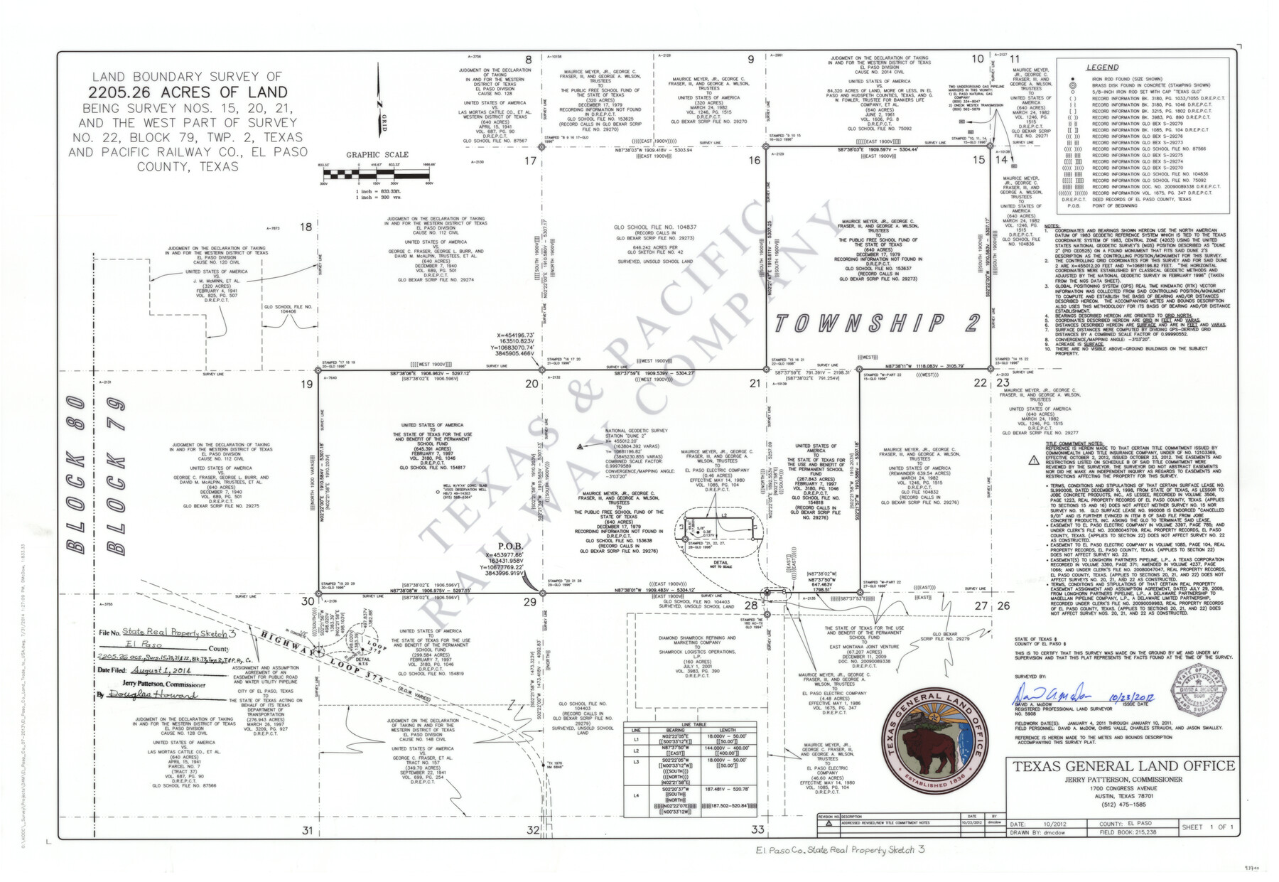
El Paso County State Real Property Sketch 3
Land boundary survey of 2205.26 acres of land being Survey Nos. 15, 20, 21 and the west part of Survey No. 22, Block 79, Twp. 2, Texas and Pacific Railway Co., El Paso County, Texas
-
Map/Doc
93700
-
Collection
General Map Collection
-
Object Dates
10/23/2012 (Creation Date)
8/1/2014 (File Date)
-
People and Organizations
Texas General Land Office (Publisher)
Jerry E. Patterson (GLO Commissioner)
David A. McDow (Surveyor/Engineer)
David A. McDow (Draftsman)
-
Counties
El Paso
-
Subjects
State Real Property
-
Height x Width
25.1 x 36.4 inches
63.8 x 92.5 cm
-
Scale
1" = 300 varas
Part of: General Map Collection
Loving County Sketch File 1

Print $4.00
- Digital $50.00
Loving County Sketch File 1
1931
Size 11.2 x 8.6 inches
Map/Doc 30407
Lampasas County Boundary File 15a

Print $33.00
- Digital $50.00
Lampasas County Boundary File 15a
Size 13.3 x 8.2 inches
Map/Doc 56210
Bell County Sketch File 23a

Print $6.00
- Digital $50.00
Bell County Sketch File 23a
1873
Size 10.0 x 15.7 inches
Map/Doc 14416
Ochiltree County Boundary File 1

Print $14.00
- Digital $50.00
Ochiltree County Boundary File 1
Size 12.7 x 8.2 inches
Map/Doc 57657
South Sulphur River, Klondike Sheet

Print $20.00
- Digital $50.00
South Sulphur River, Klondike Sheet
1925
Size 18.2 x 19.9 inches
Map/Doc 78332
Reeves County Rolled Sketch 13

Print $40.00
- Digital $50.00
Reeves County Rolled Sketch 13
1927
Size 23.6 x 72.2 inches
Map/Doc 9851
Culberson County Rolled Sketch 19A
Print $20.00
- Digital $50.00
Culberson County Rolled Sketch 19A
Size 23.2 x 28.6 inches
Map/Doc 5652
Navarro County Sketch File 8

Print $4.00
- Digital $50.00
Navarro County Sketch File 8
1849
Size 13.2 x 8.5 inches
Map/Doc 32315
Flight Mission No. DCL-7C, Frame 51, Kenedy County

Print $20.00
- Digital $50.00
Flight Mission No. DCL-7C, Frame 51, Kenedy County
1943
Size 16.6 x 16.4 inches
Map/Doc 86039
Fort Bend County Working Sketch 16

Print $20.00
- Digital $50.00
Fort Bend County Working Sketch 16
1953
Size 42.4 x 46.0 inches
Map/Doc 69222
Coke County Sketch File 25

Print $34.00
- Digital $50.00
Coke County Sketch File 25
1930
Size 14.2 x 8.9 inches
Map/Doc 18618
Hardeman County Sketch File 14

Print $8.00
- Digital $50.00
Hardeman County Sketch File 14
1884
Size 12.7 x 8.1 inches
Map/Doc 25022
You may also like
Boundary Between U.S. - Mexico, 1853

Print $20.00
- Digital $50.00
Boundary Between U.S. - Mexico, 1853
1954
Size 24.3 x 18.4 inches
Map/Doc 65416
Zapata County Sketch File 20

Print $633.00
- Digital $50.00
Zapata County Sketch File 20
1998
Size 11.5 x 8.9 inches
Map/Doc 40966
Flight Mission No. DCL-7C, Frame 73, Kenedy County

Print $20.00
- Digital $50.00
Flight Mission No. DCL-7C, Frame 73, Kenedy County
1943
Size 15.6 x 15.3 inches
Map/Doc 86059
Edwards County Working Sketch 19

Print $20.00
- Digital $50.00
Edwards County Working Sketch 19
1934
Size 24.1 x 24.6 inches
Map/Doc 68895
Hardin County Sketch File 70

Print $4.00
- Digital $50.00
Hardin County Sketch File 70
1895
Size 11.2 x 9.0 inches
Map/Doc 25257
[Gunter & Munson, Maddox Bros. & Anderson Block F] / [PSL Block B19]
![91849, [Gunter & Munson, Maddox Bros. & Anderson Block F] / [PSL Block B19], Twichell Survey Records](https://historictexasmaps.com/wmedia_w700/maps/91849-1.tif.jpg)
Print $20.00
- Digital $50.00
[Gunter & Munson, Maddox Bros. & Anderson Block F] / [PSL Block B19]
Size 18.6 x 22.0 inches
Map/Doc 91849
Polk County Sketch File 23

Print $20.00
- Digital $50.00
Polk County Sketch File 23
Size 18.0 x 18.6 inches
Map/Doc 12191

Lynn County Sketch File 2

Print $5.00
- Digital $50.00
Lynn County Sketch File 2
1902
Size 11.6 x 17.1 inches
Map/Doc 30447
Dimmit County Rolled Sketch 21

Print $20.00
- Digital $50.00
Dimmit County Rolled Sketch 21
2013
Size 25.5 x 22.5 inches
Map/Doc 93488
Flight Mission No. DCL-6C, Frame 19, Kenedy County

Print $20.00
- Digital $50.00
Flight Mission No. DCL-6C, Frame 19, Kenedy County
1943
Size 18.6 x 22.4 inches
Map/Doc 85876
Lubbock County Sketch File 15

Print $6.00
- Digital $50.00
Lubbock County Sketch File 15
1902
Size 11.2 x 8.8 inches
Map/Doc 30440