Polk County Sketch File 32
[Sketch and report southeast of Livingston]
-
Map/Doc
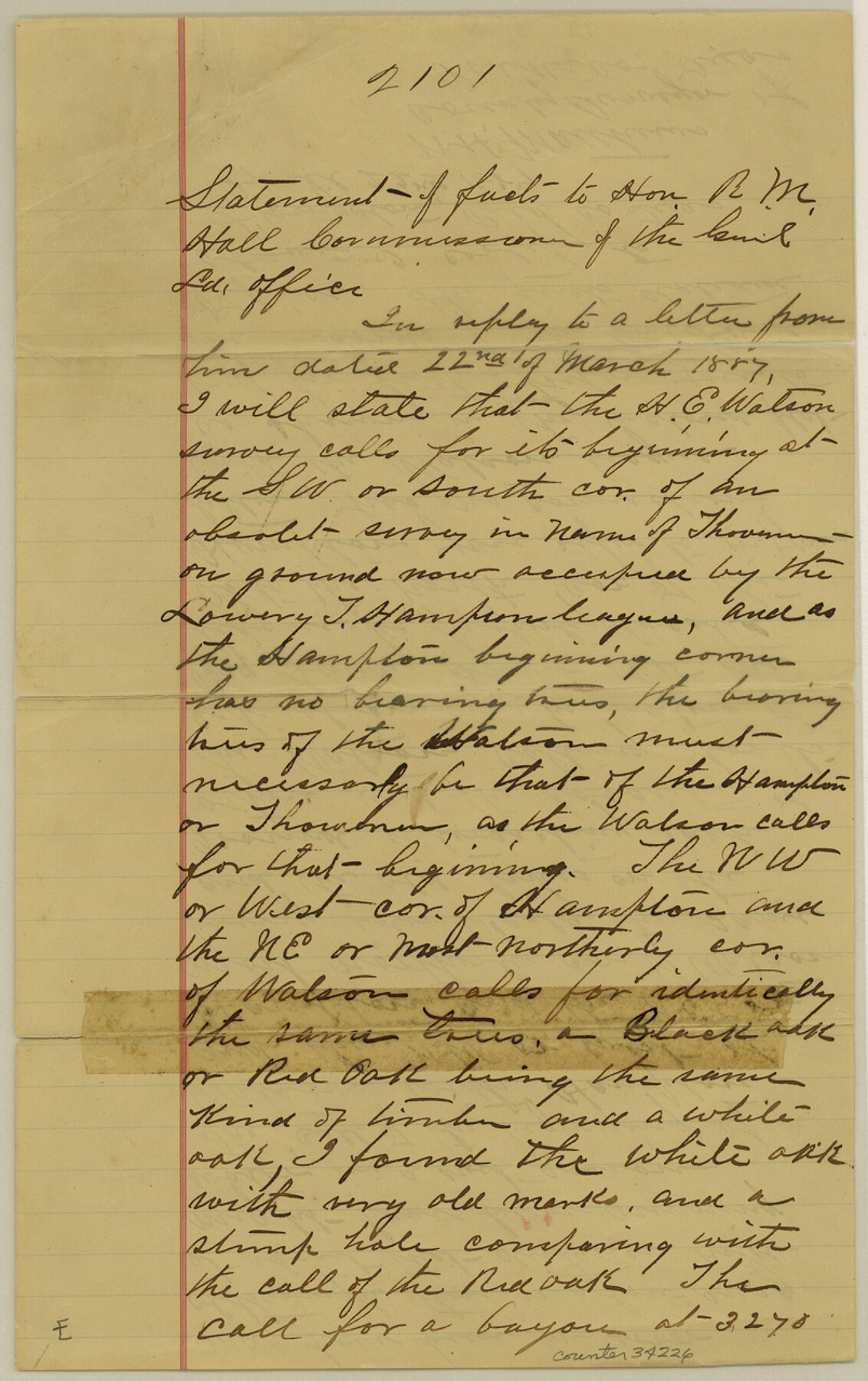
34226
-
Collection
General Map Collection
-
Object Dates
4/22/1887 (Creation Date)
-
People and Organizations
W.H. Matthews (Surveyor/Engineer)
-
Counties
Polk
-
Subjects
Surveying Sketch File
-
Height x Width
12.8 x 8.0 inches
32.5 x 20.3 cm
-
Medium
paper, manuscript
-
Features
Big Sandy Creek
Part of: General Map Collection
Pecos County Rolled Sketch 120

Print $40.00
- Digital $50.00
Pecos County Rolled Sketch 120
1945
Size 52.3 x 37.7 inches
Map/Doc 9723
Dickens County Sketch File GW1

Print $20.00
- Digital $50.00
Dickens County Sketch File GW1
1911
Size 31.5 x 24.4 inches
Map/Doc 11334
Andrews County Working Sketch 9

Print $20.00
- Digital $50.00
Andrews County Working Sketch 9
1955
Size 10.2 x 23.3 inches
Map/Doc 67055
San Patricio County Rolled Sketch 30A

Print $20.00
- Digital $50.00
San Patricio County Rolled Sketch 30A
1941
Size 23.3 x 30.4 inches
Map/Doc 9897
Tom Green County Sketch File 70

Print $6.00
- Digital $50.00
Tom Green County Sketch File 70
1945
Size 11.3 x 8.9 inches
Map/Doc 38241
Flight Mission No. BRA-6M, Frame 88, Jefferson County

Print $20.00
- Digital $50.00
Flight Mission No. BRA-6M, Frame 88, Jefferson County
1953
Size 18.4 x 22.4 inches
Map/Doc 85431
Brazos Santiago, Texas

Print $20.00
- Digital $50.00
Brazos Santiago, Texas
1882
Size 18.3 x 26.1 inches
Map/Doc 72987
Railroad Track Map, H&TCRRCo., Falls County, Texas

Print $4.00
- Digital $50.00
Railroad Track Map, H&TCRRCo., Falls County, Texas
1918
Size 11.3 x 18.5 inches
Map/Doc 62847
Culberson County Rolled Sketch 33

Print $20.00
- Digital $50.00
Culberson County Rolled Sketch 33
1937
Size 36.4 x 27.9 inches
Map/Doc 5658
Fisher County Sketch File 13

Print $20.00
- Digital $50.00
Fisher County Sketch File 13
Size 18.3 x 17.7 inches
Map/Doc 11480
Flight Mission No. BRE-2P, Frame 63, Nueces County

Print $20.00
- Digital $50.00
Flight Mission No. BRE-2P, Frame 63, Nueces County
1956
Size 18.5 x 22.5 inches
Map/Doc 86758
San Patricio County Sketch File 36

Print $26.00
- Digital $50.00
San Patricio County Sketch File 36
1940
Size 11.3 x 8.7 inches
Map/Doc 36129
You may also like
Map of the United States

Print $20.00
- Digital $50.00
Map of the United States
1851
Size 24.7 x 26.0 inches
Map/Doc 96632
Aransas Pass to Baffin Bay

Print $20.00
- Digital $50.00
Aransas Pass to Baffin Bay
1973
Size 42.0 x 35.1 inches
Map/Doc 73418
Map of Kinney County

Print $40.00
- Digital $50.00
Map of Kinney County
1889
Size 50.1 x 41.1 inches
Map/Doc 16869
McMullen County Sketch File 38

Print $20.00
- Digital $50.00
McMullen County Sketch File 38
1938
Size 31.3 x 17.5 inches
Map/Doc 12064

Galveston County NRC Article 33.136 Sketch 26

Print $45.00
- Digital $50.00
Galveston County NRC Article 33.136 Sketch 26
2003
Size 32.6 x 24.3 inches
Map/Doc 81943
Flight Mission No. BRE-2P, Frame 135, Nueces County

Print $20.00
- Digital $50.00
Flight Mission No. BRE-2P, Frame 135, Nueces County
1956
Size 18.5 x 22.7 inches
Map/Doc 86808
Rains County Working Sketch 9

Print $20.00
- Digital $50.00
Rains County Working Sketch 9
1976
Size 35.8 x 31.9 inches
Map/Doc 71835
Gaines County Rolled Sketch 27

Print $20.00
- Digital $50.00
Gaines County Rolled Sketch 27
1983
Size 35.6 x 41.8 inches
Map/Doc 9042
[Borden County Lines - Description of County Line Markers]
![90215, [Borden County Lines - Description of County Line Markers], Twichell Survey Records](https://historictexasmaps.com/wmedia_w700/maps/90215-1.tif.jpg)
Print $3.00
- Digital $50.00
[Borden County Lines - Description of County Line Markers]
Size 14.4 x 10.1 inches
Map/Doc 90215
Harris County Boundary File 39 (16)

Print $6.00
- Digital $50.00
Harris County Boundary File 39 (16)
Size 10.0 x 8.0 inches
Map/Doc 54354
1883 Map of the Texas & Pacific R-Y Reserve

Print $40.00
- Digital $50.00
1883 Map of the Texas & Pacific R-Y Reserve
1883
Size 42.2 x 86.4 inches
Map/Doc 2236