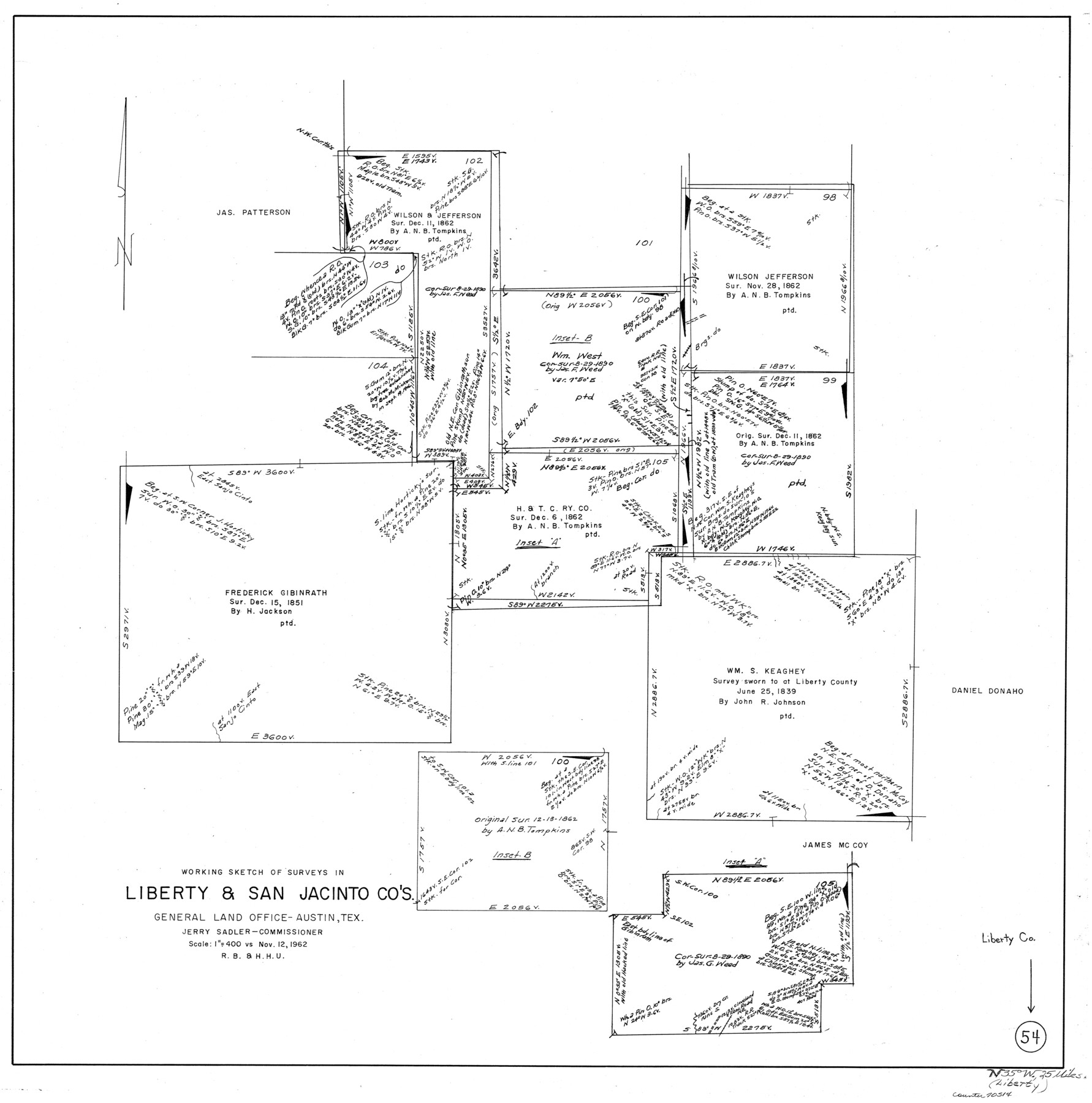
Liberty County Working Sketch 54
-
Map/Doc
70514
-
Collection
General Map Collection
-
Object Dates
11/12/1962 (Creation Date)
-
People and Organizations
Roy Buckholts (Draftsman)
Herbert H. Ulbricht (Draftsman)
-
Counties
Liberty San Jacinto
-
Subjects
Surveying Working Sketch
-
Height x Width
29.8 x 29.5 inches
75.7 x 74.9 cm
-
Scale
1" = 400 varas
Part of: General Map Collection
Haskell County Working Sketch 17

Print $20.00
- Digital $50.00
Haskell County Working Sketch 17
2011
Size 34.3 x 32.3 inches
Map/Doc 89989
National Railways of Mexico

Digital $50.00
National Railways of Mexico
1966
Size 8.9 x 17.6 inches
Map/Doc 94189
Brewster County Sketch File 44

Print $3.00
- Digital $50.00
Brewster County Sketch File 44
Size 11.5 x 9.4 inches
Map/Doc 16311
Flight Mission No. DAH-17M, Frame 68, Orange County

Print $20.00
- Digital $50.00
Flight Mission No. DAH-17M, Frame 68, Orange County
1953
Size 18.6 x 22.4 inches
Map/Doc 86902
Map representing the surveys made in Bexar County

Print $40.00
- Digital $50.00
Map representing the surveys made in Bexar County
1839
Size 75.7 x 35.1 inches
Map/Doc 93365
Flight Mission No. DQN-5K, Frame 55, Calhoun County

Print $20.00
- Digital $50.00
Flight Mission No. DQN-5K, Frame 55, Calhoun County
1953
Size 18.7 x 22.3 inches
Map/Doc 84398
Map of section no. 4 of a survey of Padre Island made for the Office of the Attorney General of the State of Texas

Print $40.00
- Digital $50.00
Map of section no. 4 of a survey of Padre Island made for the Office of the Attorney General of the State of Texas
1941
Size 82.6 x 40.8 inches
Map/Doc 2260
[Jose Pineda grant]
![123, [Jose Pineda grant], General Map Collection](https://historictexasmaps.com/wmedia_w700/maps/123.tif.jpg)
Print $2.00
- Digital $50.00
[Jose Pineda grant]
1846
Size 13.6 x 7.7 inches
Map/Doc 123
Colorado County Sketch File 17

Print $22.00
- Digital $50.00
Colorado County Sketch File 17
Size 8.7 x 7.7 inches
Map/Doc 18949
Sectional Map No. 2 of the lands and the line of the Texas & Pacific Ry. Co. in Howard, Martin, Andrews, Midland and Tom Green Counties

Print $20.00
- Digital $50.00
Sectional Map No. 2 of the lands and the line of the Texas & Pacific Ry. Co. in Howard, Martin, Andrews, Midland and Tom Green Counties
1885
Size 18.9 x 23.2 inches
Map/Doc 4861
[Surveys in Austin's Colony along the Navidad River; John P. Borden for Thos. H. Borden]
![77, [Surveys in Austin's Colony along the Navidad River; John P. Borden for Thos. H. Borden], General Map Collection](https://historictexasmaps.com/wmedia_w700/maps/77.tif.jpg)
Print $20.00
- Digital $50.00
[Surveys in Austin's Colony along the Navidad River; John P. Borden for Thos. H. Borden]
1831
Size 20.6 x 9.3 inches
Map/Doc 77
Rio Grande, Donna Sheet

Print $20.00
- Digital $50.00
Rio Grande, Donna Sheet
1937
Size 37.5 x 37.4 inches
Map/Doc 65117
You may also like
Culberson County Working Sketch 89

Print $20.00
- Digital $50.00
Culberson County Working Sketch 89
1984
Size 34.6 x 30.0 inches
Map/Doc 68543
Foard County Sketch File 38

Print $11.00
- Digital $50.00
Foard County Sketch File 38
1890
Size 11.1 x 7.2 inches
Map/Doc 22871
Jones County Sketch File 18

Print $6.00
- Digital $50.00
Jones County Sketch File 18
1981
Size 13.9 x 11.0 inches
Map/Doc 28514
Map exhibiting the lines of march passed over by the troops of the United States during the year ending June 30th, 1858 prepared by order of the Hon. J.B. Floyd, Sec. War.

Print $20.00
- Digital $50.00
Map exhibiting the lines of march passed over by the troops of the United States during the year ending June 30th, 1858 prepared by order of the Hon. J.B. Floyd, Sec. War.
1858
Size 20.0 x 20.3 inches
Map/Doc 94079
Chambers County Working Sketch 15

Print $20.00
- Digital $50.00
Chambers County Working Sketch 15
1958
Size 32.9 x 27.4 inches
Map/Doc 67998
Map of Llano County, Texas

Print $20.00
Map of Llano County, Texas
1879
Size 23.1 x 21.2 inches
Map/Doc 88970
Approaches to Galveston Bay

Print $40.00
- Digital $50.00
Approaches to Galveston Bay
1982
Size 53.1 x 36.7 inches
Map/Doc 69884
Knox County Working Sketch 9

Print $20.00
- Digital $50.00
Knox County Working Sketch 9
1945
Size 33.8 x 43.3 inches
Map/Doc 70251
Crockett County Rolled Sketch 76

Print $20.00
- Digital $50.00
Crockett County Rolled Sketch 76
1950
Size 24.6 x 26.1 inches
Map/Doc 5617
Crockett County Rolled Sketch CRV

Print $40.00
- Digital $50.00
Crockett County Rolled Sketch CRV
1925
Size 35.8 x 52.3 inches
Map/Doc 8693
[Blocks Z3, S, H1 and 1 and vicinity]
![93120, [Blocks Z3, S, H1 and 1 and vicinity], Twichell Survey Records](https://historictexasmaps.com/wmedia_w700/maps/93120-1.tif.jpg)
Print $40.00
- Digital $50.00
[Blocks Z3, S, H1 and 1 and vicinity]
Size 54.0 x 32.2 inches
Map/Doc 93120
Flight Mission No. BRA-7M, Frame 41, Jefferson County

Print $20.00
- Digital $50.00
Flight Mission No. BRA-7M, Frame 41, Jefferson County
1953
Size 18.6 x 22.3 inches
Map/Doc 85492