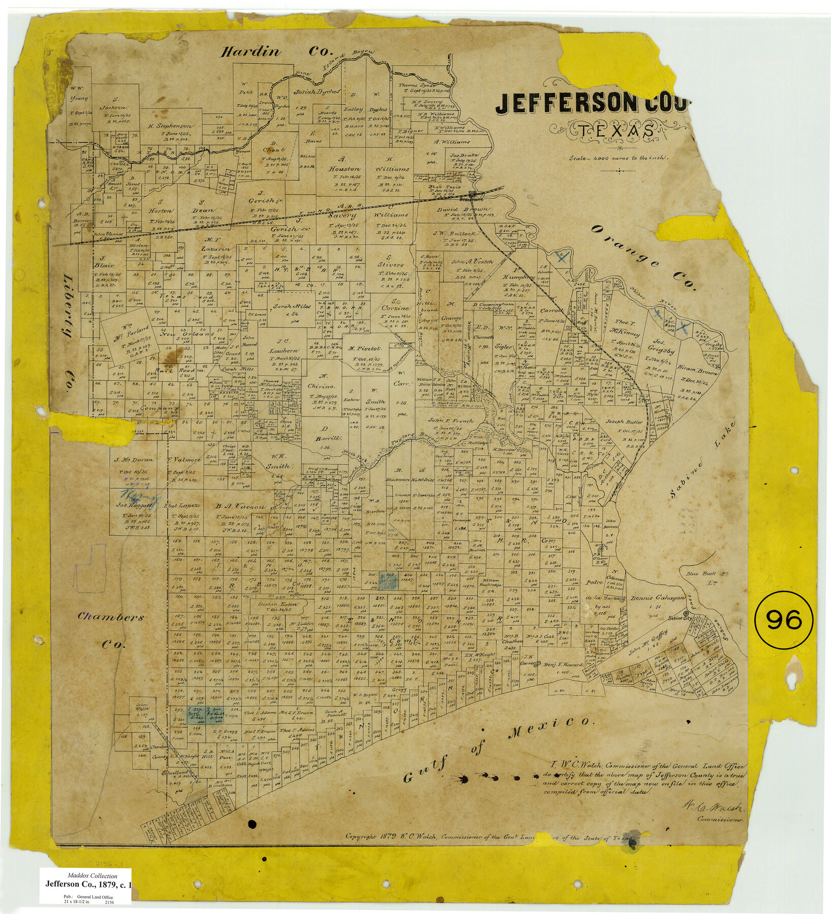
Jefferson County, Texas
-
Map/Doc
521
-
Collection
Maddox Collection
-
Object Dates
1879 (Creation Date)
1879 (Copyright Date)
-
People and Organizations
General Land Office (Publisher)
W.C. Walsh (GLO Commissioner)
-
Counties
Jefferson
-
Subjects
County
-
Height x Width
21.7 x 18.8 inches
55.1 x 47.8 cm
-
Medium
paper, etching/engraving/lithograph
-
Scale
1:4000
-
Comments
Conservation funded in 2009.
-
Features
Taylors Bayou
Gulf of Mexico
Sabine Pass
Sabine City
Blue Buck Island
Blue Buck Point
Round Lake
Sabine Lake
Salt Bayou
Mayhew B[ayou]
South Fork [of] Taylor's Bayou
North Fork [of] Taylors Bayou
Pine Island Bayou
Rodairs Bayou
Alligator B[ayou]
Neches River
South Fork of [Hillebrand's] Bayou
North Fork [of Hillebrand's Bayou]
Double Point Bayou
Cotton Creek
Marsh Bayou
T&NO
Beaumont
Part of: Maddox Collection
[Sketch of Surveys in] Tom Green County, [Texas]
![471, [Sketch of Surveys in] Tom Green County, [Texas]](https://historictexasmaps.com/wmedia_w700/maps/0471.tif.jpg)
Print $20.00
- Digital $50.00
[Sketch of Surveys in] Tom Green County, [Texas]
1882
Size 14.1 x 20.3 inches
Map/Doc 471
Map of surveys 189 & 190, T. C. R.R. Co. in Travis County, Texas

Print $20.00
- Digital $50.00
Map of surveys 189 & 190, T. C. R.R. Co. in Travis County, Texas
1915
Size 16.3 x 23.5 inches
Map/Doc 75762
[Sketch of surveys in Knox County]
![555, [Sketch of surveys in Knox County], Maddox Collection](https://historictexasmaps.com/wmedia_w700/maps/555.tif.jpg)
Print $20.00
- Digital $50.00
[Sketch of surveys in Knox County]
Size 27.1 x 31.1 inches
Map/Doc 555
Graham's Addition Being a Subdivision of a Portion of Lot No. 1 of Spear League

Print $20.00
- Digital $50.00
Graham's Addition Being a Subdivision of a Portion of Lot No. 1 of Spear League
1914
Size 13.6 x 33.0 inches
Map/Doc 542
Childress County, Texas

Print $20.00
- Digital $50.00
Childress County, Texas
1892
Size 29.3 x 22.0 inches
Map/Doc 697
Map of Duval County, Texas

Print $20.00
- Digital $50.00
Map of Duval County, Texas
1880
Size 31.4 x 21.8 inches
Map/Doc 5030
McCulloch County, Texas

Print $20.00
- Digital $50.00
McCulloch County, Texas
1879
Size 24.6 x 18.0 inches
Map/Doc 573
Trinity County, Texas

Print $20.00
- Digital $50.00
Trinity County, Texas
1879
Size 15.8 x 23.8 inches
Map/Doc 761
[Sketch showing voting precincts in Jim Hogg and Brooks Counties]
![4497, [Sketch showing voting precincts in Jim Hogg and Brooks Counties], Maddox Collection](https://historictexasmaps.com/wmedia_w700/maps/4497-1.tif.jpg)
Print $20.00
- Digital $50.00
[Sketch showing voting precincts in Jim Hogg and Brooks Counties]
Size 10.1 x 18.2 inches
Map/Doc 4497
[L.C. Ferguson Survey, Irion County]
![537, [L.C. Ferguson Survey, Irion County], Maddox Collection](https://historictexasmaps.com/wmedia_w700/maps/0537.tif.jpg)
Print $3.00
- Digital $50.00
[L.C. Ferguson Survey, Irion County]
Size 11.8 x 12.3 inches
Map/Doc 537
[Sketch Showing L. Gonzales, Wm. H. McBee and adjacent surveys, Kaufman County, Texas]
![5071, [Sketch Showing L. Gonzales, Wm. H. McBee and adjacent surveys, Kaufman County, Texas], Maddox Collection](https://historictexasmaps.com/wmedia_w700/maps/5071.tif.jpg)
Print $20.00
- Digital $50.00
[Sketch Showing L. Gonzales, Wm. H. McBee and adjacent surveys, Kaufman County, Texas]
Size 23.2 x 19.8 inches
Map/Doc 5071
[Sketch Showing Loma Blanca , El Tule and San Antonio de Encinal Leagues in Brooks County, Texas]
![624, [Sketch Showing Loma Blanca , El Tule and San Antonio de Encinal Leagues in Brooks County, Texas], Maddox Collection](https://historictexasmaps.com/wmedia_w700/maps/00624.tif.jpg)
Print $3.00
- Digital $50.00
[Sketch Showing Loma Blanca , El Tule and San Antonio de Encinal Leagues in Brooks County, Texas]
Size 9.3 x 14.2 inches
Map/Doc 624
You may also like
Flight Mission No. CGI-3N, Frame 168, Cameron County

Print $20.00
- Digital $50.00
Flight Mission No. CGI-3N, Frame 168, Cameron County
1954
Size 18.5 x 22.6 inches
Map/Doc 84632
Sterling County Rolled Sketch 23A

Print $131.00
- Digital $50.00
Sterling County Rolled Sketch 23A
Size 10.6 x 15.2 inches
Map/Doc 49032
West Part Presidio Co.

Print $20.00
- Digital $50.00
West Part Presidio Co.
1974
Size 40.5 x 31.4 inches
Map/Doc 77399
Real County Working Sketch 60

Print $40.00
- Digital $50.00
Real County Working Sketch 60
1963
Size 60.4 x 41.1 inches
Map/Doc 71952
Edwards County Rolled Sketch J

Print $83.00
- Digital $50.00
Edwards County Rolled Sketch J
1918
Size 23.6 x 30.3 inches
Map/Doc 5818
Childress County Sketch File 18a

Print $4.00
- Digital $50.00
Childress County Sketch File 18a
1935
Size 11.3 x 7.1 inches
Map/Doc 18364
Hudspeth County Working Sketch 21

Print $20.00
- Digital $50.00
Hudspeth County Working Sketch 21
1966
Size 22.8 x 41.6 inches
Map/Doc 66303
University Lands Blocks 27 & 28, Pecos County

Print $20.00
- Digital $50.00
University Lands Blocks 27 & 28, Pecos County
1940
Size 33.6 x 21.1 inches
Map/Doc 2449
[Surveys East of river copied from U.S. map of Township No. 6 South, Range No. 9 West of the Indian Meridian, Oklahoma]
![75186, [Surveys East of river copied from U.S. map of Township No. 6 South, Range No. 9 West of the Indian Meridian, Oklahoma], General Map Collection](https://historictexasmaps.com/wmedia_w700/maps/75186.tif.jpg)
Print $2.00
- Digital $50.00
[Surveys East of river copied from U.S. map of Township No. 6 South, Range No. 9 West of the Indian Meridian, Oklahoma]
Size 13.3 x 9.2 inches
Map/Doc 75186
[The S.K. Ry. of Texas, State Line to Pecos, Reeves Co., Texas]
![64159, [The S.K. Ry. of Texas, State Line to Pecos, Reeves Co., Texas], General Map Collection](https://historictexasmaps.com/wmedia_w700/maps/64159.tif.jpg)
Print $40.00
- Digital $50.00
[The S.K. Ry. of Texas, State Line to Pecos, Reeves Co., Texas]
1910
Size 19.4 x 130.6 inches
Map/Doc 64159
Flight Mission No. BQR-22K, Frame 46, Brazoria County

Print $20.00
- Digital $50.00
Flight Mission No. BQR-22K, Frame 46, Brazoria County
1953
Size 18.6 x 22.4 inches
Map/Doc 84130
Rains County Working Sketch Graphic Index

Print $20.00
- Digital $50.00
Rains County Working Sketch Graphic Index
1942
Size 31.3 x 29.5 inches
Map/Doc 76675