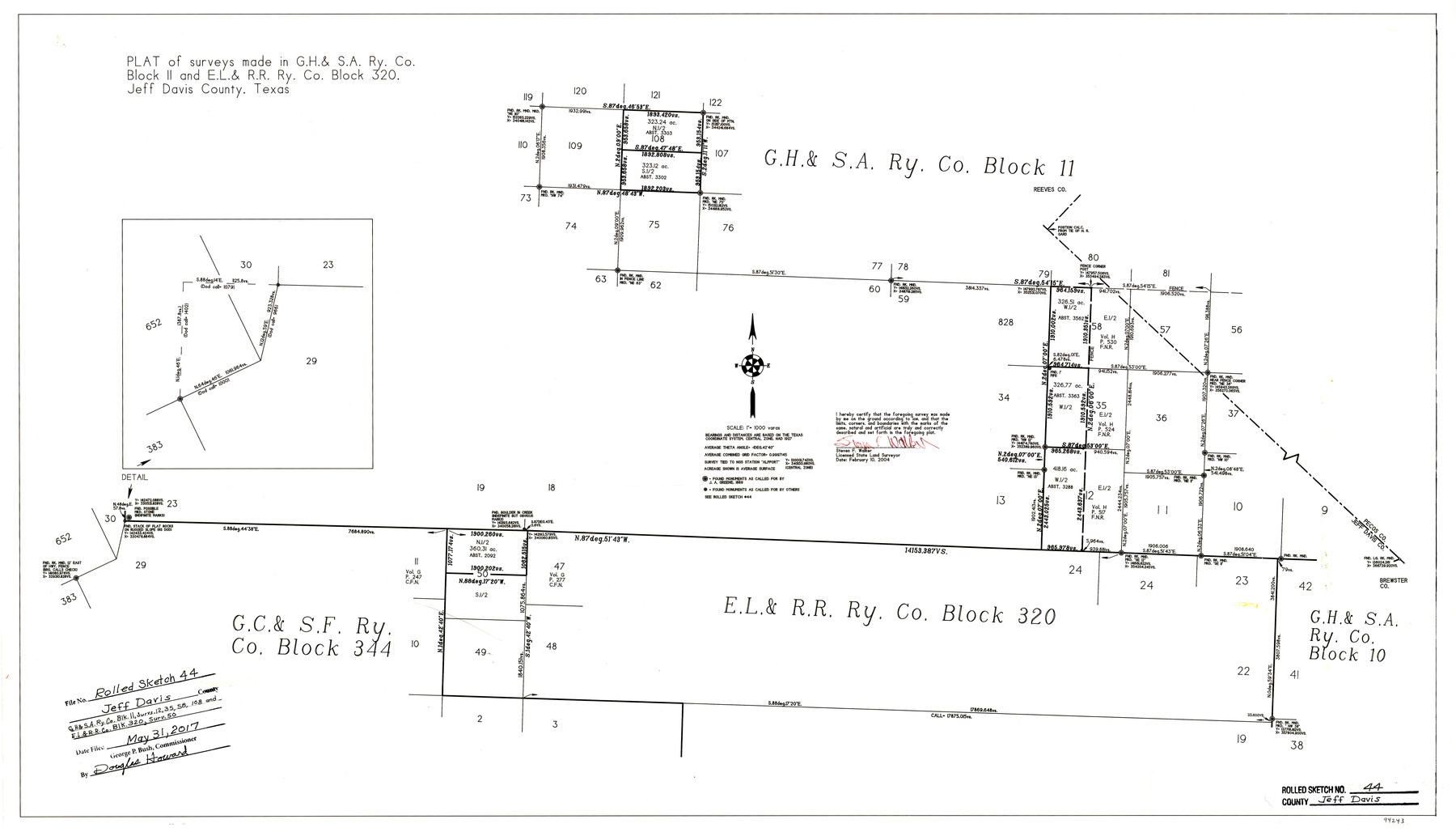
Jeff Davis County Rolled Sketch 44
Plat of surveys made in G. H. & S. A. Ry. Co. Block 11 and E. L. & R. R. Ry. Co. Block 320, Jeff Davis County, Texas
-
Map/Doc
94243
-
Collection
General Map Collection
-
Object Dates
2014/2/10 (Creation Date)
2017/5/31 (File Date)
-
People and Organizations
Steven F. Walker (Surveyor/Engineer)
-
Counties
Jeff Davis
-
Subjects
Surveying Rolled Sketch
-
Height x Width
19.8 x 34.7 inches
50.3 x 88.1 cm
-
Medium
mylar, print
-
Scale
1" = 1000 varas
Part of: General Map Collection
McMullen County Sketch File 41

Print $20.00
- Digital $50.00
McMullen County Sketch File 41
1939
Size 20.6 x 17.1 inches
Map/Doc 12065
Hale County Working Sketch 2

Print $20.00
- Digital $50.00
Hale County Working Sketch 2
1916
Size 13.5 x 13.1 inches
Map/Doc 63322
Flight Mission No. BQR-12K, Frame 48, Brazoria County

Print $20.00
- Digital $50.00
Flight Mission No. BQR-12K, Frame 48, Brazoria County
1952
Size 19.0 x 22.7 inches
Map/Doc 84063
Red River County Sketch File 1a

Print $4.00
- Digital $50.00
Red River County Sketch File 1a
1854
Size 12.7 x 8.0 inches
Map/Doc 35093
Harris County Working Sketch 33

Print $20.00
- Digital $50.00
Harris County Working Sketch 33
1937
Size 21.4 x 20.6 inches
Map/Doc 65925
Runnels County Working Sketch 5

Print $20.00
- Digital $50.00
Runnels County Working Sketch 5
1907
Size 17.2 x 16.1 inches
Map/Doc 63601
Flight Mission No. CLL-1N, Frame 9, Willacy County

Print $20.00
- Digital $50.00
Flight Mission No. CLL-1N, Frame 9, Willacy County
1954
Size 18.4 x 22.1 inches
Map/Doc 86996
Crockett County Rolled Sketch 47

Print $20.00
- Digital $50.00
Crockett County Rolled Sketch 47
1939
Size 22.2 x 21.1 inches
Map/Doc 5596
Texas, Intracoastal Waterway, Ayres Bay to Aransas Bay

Print $40.00
- Digital $50.00
Texas, Intracoastal Waterway, Ayres Bay to Aransas Bay
1934
Size 33.2 x 48.5 inches
Map/Doc 69997
Crosby County Working Sketch 12

Print $20.00
- Digital $50.00
Crosby County Working Sketch 12
1953
Size 26.0 x 29.8 inches
Map/Doc 68446
Cameron County Rolled Sketch 20D

Print $20.00
- Digital $50.00
Cameron County Rolled Sketch 20D
Size 14.3 x 13.9 inches
Map/Doc 5477
Flight Mission No. DIX-8P, Frame 61, Aransas County

Print $20.00
- Digital $50.00
Flight Mission No. DIX-8P, Frame 61, Aransas County
1956
Size 18.8 x 22.6 inches
Map/Doc 83892
You may also like
Jefferson County Sketch File 22

Print $22.00
- Digital $50.00
Jefferson County Sketch File 22
Size 7.6 x 11.9 inches
Map/Doc 28179
Sketch Showing Block 142, Original Town, Survey 1, Block O

Print $20.00
- Digital $50.00
Sketch Showing Block 142, Original Town, Survey 1, Block O
Size 23.0 x 18.0 inches
Map/Doc 92782
Petersburg, Hale County, Texas

Print $20.00
- Digital $50.00
Petersburg, Hale County, Texas
1927
Size 16.1 x 28.4 inches
Map/Doc 92699
Map Showing the Relative Positions of the Various Surveys Delineated Thereon

Print $20.00
- Digital $50.00
Map Showing the Relative Positions of the Various Surveys Delineated Thereon
Size 23.0 x 18.6 inches
Map/Doc 91500
Texas Boundary Line

Print $20.00
- Digital $50.00
Texas Boundary Line
Size 21.6 x 11.9 inches
Map/Doc 92078
Flight Mission No. BQY-4M, Frame 125, Harris County

Print $20.00
- Digital $50.00
Flight Mission No. BQY-4M, Frame 125, Harris County
1953
Size 18.6 x 22.5 inches
Map/Doc 85293
[Leagues 27, 28, 69, 70, 71, 72, and 73]
![91096, [Leagues 27, 28, 69, 70, 71, 72, and 73], Twichell Survey Records](https://historictexasmaps.com/wmedia_w700/maps/91096-1.tif.jpg)
Print $20.00
- Digital $50.00
[Leagues 27, 28, 69, 70, 71, 72, and 73]
Size 24.0 x 15.7 inches
Map/Doc 91096
Photo Index of Texas Coast - Sheet 5 of 6

Print $20.00
- Digital $50.00
Photo Index of Texas Coast - Sheet 5 of 6
1954
Size 20.0 x 24.0 inches
Map/Doc 83443
[South Center of County near surveys 1144 and 1143]
![90502, [South Center of County near surveys 1144 and 1143], Twichell Survey Records](https://historictexasmaps.com/wmedia_w700/maps/90502-1.tif.jpg)
Print $2.00
- Digital $50.00
[South Center of County near surveys 1144 and 1143]
Size 6.6 x 16.1 inches
Map/Doc 90502

Cottle County Working Sketch 6

Print $20.00
- Digital $50.00
Cottle County Working Sketch 6
1927
Size 23.0 x 29.3 inches
Map/Doc 68316
Carson County Sketch File 3

Print $32.00
- Digital $50.00
Carson County Sketch File 3
1888
Size 5.4 x 8.4 inches
Map/Doc 17335