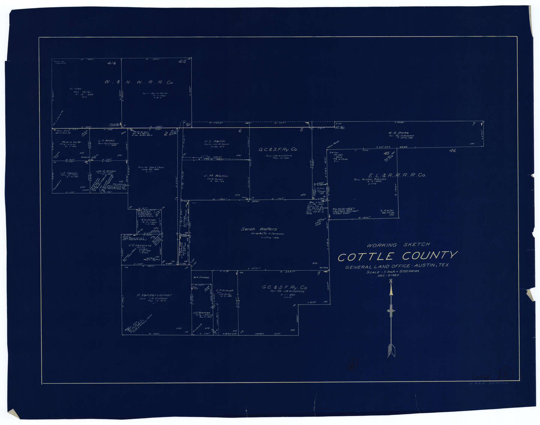
Cottle County Working Sketch 6
-
Map/Doc
68316
-
Collection
General Map Collection
-
Object Dates
12/8/1927 (Creation Date)
-
Counties
Cottle
-
Subjects
Surveying Working Sketch
-
Height x Width
23.0 x 29.3 inches
58.4 x 74.4 cm
-
Scale
1" = 500 varas
Part of: General Map Collection
Hamilton County Working Sketch 12

Print $20.00
- Digital $50.00
Hamilton County Working Sketch 12
1949
Size 43.9 x 41.7 inches
Map/Doc 63350
Angelina County Sketch File 26

Print $40.00
- Digital $50.00
Angelina County Sketch File 26
1909
Size 18.0 x 23.0 inches
Map/Doc 10817
San Patricio County Working Sketch 26

Print $20.00
- Digital $50.00
San Patricio County Working Sketch 26
1986
Size 29.0 x 34.4 inches
Map/Doc 63788
Aransas County Sketch File 32

Print $12.00
- Digital $50.00
Aransas County Sketch File 32
1919
Size 14.2 x 9.0 inches
Map/Doc 13297
El Paso County Rolled Sketch 18

Print $20.00
- Digital $50.00
El Paso County Rolled Sketch 18
Size 30.0 x 33.4 inches
Map/Doc 5822
Montgomery County Working Sketch 41

Print $20.00
- Digital $50.00
Montgomery County Working Sketch 41
1955
Size 22.9 x 23.6 inches
Map/Doc 71148
United States - Gulf Coast - Galveston to Rio Grande

Print $20.00
- Digital $50.00
United States - Gulf Coast - Galveston to Rio Grande
1919
Size 27.1 x 18.3 inches
Map/Doc 72745
Tarrant County Working Sketch 8

Print $20.00
- Digital $50.00
Tarrant County Working Sketch 8
1982
Size 33.2 x 19.7 inches
Map/Doc 62425
Hansford County Sketch File 3

Print $20.00
- Digital $50.00
Hansford County Sketch File 3
Size 18.6 x 23.1 inches
Map/Doc 11620
Potter County Sketch File 16

Print $38.00
- Digital $50.00
Potter County Sketch File 16
Size 13.0 x 13.9 inches
Map/Doc 34401
Edwards County Rolled Sketch 7

Print $20.00
- Digital $50.00
Edwards County Rolled Sketch 7
1881
Size 24.4 x 23.2 inches
Map/Doc 5800
Real County Rolled Sketch 17

Print $20.00
- Digital $50.00
Real County Rolled Sketch 17
1906
Size 25.1 x 28.8 inches
Map/Doc 7459
You may also like
Flight Mission No. CRC-3R, Frame 34, Chambers County

Print $20.00
- Digital $50.00
Flight Mission No. CRC-3R, Frame 34, Chambers County
1956
Size 18.5 x 22.3 inches
Map/Doc 84807
General Highway Map, Live Oak County, Texas

Print $20.00
General Highway Map, Live Oak County, Texas
1940
Size 18.5 x 24.8 inches
Map/Doc 79176
Coleman County Sketch File 42

Print $24.00
- Digital $50.00
Coleman County Sketch File 42
1891
Size 5.8 x 8.9 inches
Map/Doc 18763
Jack County Sketch File 19

Print $4.00
- Digital $50.00
Jack County Sketch File 19
1878
Size 10.4 x 8.3 inches
Map/Doc 27559
General Highway Map. Detail of Cities and Towns in Cameron County, Texas [San Benito, Harlingen, Brownsville and vicinity]
![79399, General Highway Map. Detail of Cities and Towns in Cameron County, Texas [San Benito, Harlingen, Brownsville and vicinity], Texas State Library and Archives](https://historictexasmaps.com/wmedia_w700/maps/79399.tif.jpg)
Print $20.00
General Highway Map. Detail of Cities and Towns in Cameron County, Texas [San Benito, Harlingen, Brownsville and vicinity]
1961
Size 18.0 x 24.7 inches
Map/Doc 79399
Tarrant County Sketch File 20

Print $4.00
- Digital $50.00
Tarrant County Sketch File 20
1857
Size 7.0 x 7.3 inches
Map/Doc 37723

Young County Rolled Sketch 17

Print $20.00
- Digital $50.00
Young County Rolled Sketch 17
1984
Size 17.5 x 24.0 inches
Map/Doc 8305
Gray County Sketch File 13

Print $20.00
- Digital $50.00
Gray County Sketch File 13
1946
Size 16.7 x 15.9 inches
Map/Doc 11578
Scurry County Sketch File 3

Print $20.00
- Digital $50.00
Scurry County Sketch File 3
Size 22.0 x 24.2 inches
Map/Doc 12312
Red River Co.

Print $20.00
- Digital $50.00
Red River Co.
1897
Size 46.8 x 36.0 inches
Map/Doc 16796
Panola County Sketch File 29

Print $7.00
- Digital $50.00
Panola County Sketch File 29
1842
Size 10.0 x 8.1 inches
Map/Doc 33502