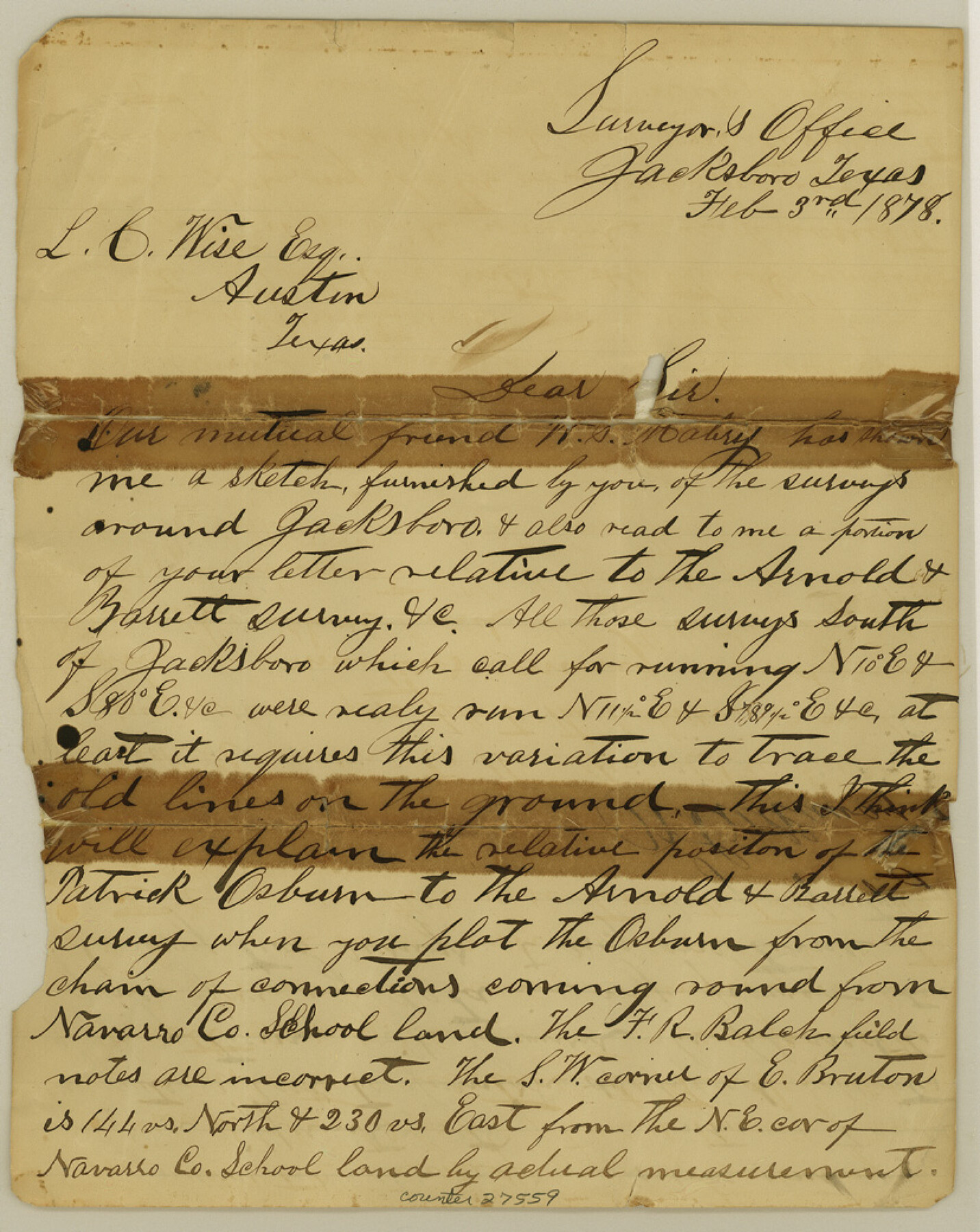
Jack County Sketch File 19
[Explanation of courses of lines south of Jacksboro]
-
Map/Doc
27559
-
Collection
General Map Collection
-
Object Dates
1878/2/3 (Creation Date)
1878/2/3 (Correspondence Date)
-
People and Organizations
Wesley Callaway (Surveyor/Engineer)
-
Counties
Jack
-
Subjects
Surveying Sketch File
-
Height x Width
10.4 x 8.3 inches
26.4 x 21.1 cm
-
Medium
paper, manuscript
Part of: General Map Collection
Duval County Rolled Sketch 37

Print $20.00
- Digital $50.00
Duval County Rolled Sketch 37
Size 27.1 x 17.9 inches
Map/Doc 5752
Cameron County Sketch File 8

Print $73.00
- Digital $50.00
Cameron County Sketch File 8
1982
Size 11.4 x 8.9 inches
Map/Doc 17124
Strip Map of Texas-Oklahoma Boundary from Denison East to the Oklahoma-Arkansas State Line

Print $20.00
- Digital $50.00
Strip Map of Texas-Oklahoma Boundary from Denison East to the Oklahoma-Arkansas State Line
1933
Size 37.7 x 24.5 inches
Map/Doc 75927
Polk County Sketch File 25

Print $46.00
- Digital $50.00
Polk County Sketch File 25
Size 5.7 x 28.2 inches
Map/Doc 34176
Menard County Working Sketch 4

Print $20.00
- Digital $50.00
Menard County Working Sketch 4
1914
Size 19.8 x 16.2 inches
Map/Doc 70951
Concho County Rolled Sketch 4

Print $20.00
- Digital $50.00
Concho County Rolled Sketch 4
1948
Size 47.3 x 43.6 inches
Map/Doc 8649
Real County Working Sketch 13

Print $20.00
- Digital $50.00
Real County Working Sketch 13
1931
Size 24.2 x 33.3 inches
Map/Doc 71905
Van Zandt County Sketch File 28

Print $4.00
- Digital $50.00
Van Zandt County Sketch File 28
1859
Size 12.5 x 8.2 inches
Map/Doc 39451
Edwards County Working Sketch 36

Print $20.00
- Digital $50.00
Edwards County Working Sketch 36
1948
Size 46.7 x 44.5 inches
Map/Doc 68912
Webb County Working Sketch 61

Print $20.00
- Digital $50.00
Webb County Working Sketch 61
1960
Size 24.7 x 28.0 inches
Map/Doc 72427
Comanche County Working Sketch 26

Print $20.00
- Digital $50.00
Comanche County Working Sketch 26
1981
Size 26.0 x 32.4 inches
Map/Doc 68160
Hopkins County Sketch File 13

Print $4.00
- Digital $50.00
Hopkins County Sketch File 13
1858
Size 12.7 x 8.2 inches
Map/Doc 26709
You may also like
Jeff Davis County Boundary File 2a

Print $40.00
- Digital $50.00
Jeff Davis County Boundary File 2a
Size 11.1 x 36.7 inches
Map/Doc 55512
Flight Mission No. DQN-3K, Frame 33, Calhoun County

Print $20.00
- Digital $50.00
Flight Mission No. DQN-3K, Frame 33, Calhoun County
1953
Size 18.6 x 22.3 inches
Map/Doc 84346
San Patricio County Sketch File 40

Print $4.00
- Digital $50.00
San Patricio County Sketch File 40
1842
Size 10.5 x 8.2 inches
Map/Doc 36236
Harris County Working Sketch 27

Print $20.00
- Digital $50.00
Harris County Working Sketch 27
1933
Size 36.9 x 43.0 inches
Map/Doc 65919
Outer Continental Shelf Leasing Maps (Texas Offshore Operations)

Print $20.00
- Digital $50.00
Outer Continental Shelf Leasing Maps (Texas Offshore Operations)
1954
Size 20.8 x 15.8 inches
Map/Doc 75838
Motley County Sketch File 33 (S)

Print $6.00
- Digital $50.00
Motley County Sketch File 33 (S)
1914
Size 7.4 x 8.5 inches
Map/Doc 32217
El Paso County Rolled Sketch 60

Print $20.00
- Digital $50.00
El Paso County Rolled Sketch 60
1992
Size 29.0 x 36.5 inches
Map/Doc 5852
Shackelford County Working Sketch 5

Print $20.00
- Digital $50.00
Shackelford County Working Sketch 5
1936
Size 22.5 x 31.6 inches
Map/Doc 63845
Austin County Working Sketch 4

Print $20.00
- Digital $50.00
Austin County Working Sketch 4
1959
Size 29.8 x 34.8 inches
Map/Doc 67245
General Highway Map, Wichita County, Texas

Print $20.00
General Highway Map, Wichita County, Texas
1940
Size 18.1 x 24.8 inches
Map/Doc 79277
Sketch of the line of march of the 2nd US Dragoons commanded by Col D. E. Tuiggs from Fort Jesup, La to Corpus Christi, Texas between the 25th of July and the 27th Aug, 1845

Print $20.00
- Digital $50.00
Sketch of the line of march of the 2nd US Dragoons commanded by Col D. E. Tuiggs from Fort Jesup, La to Corpus Christi, Texas between the 25th of July and the 27th Aug, 1845
1845
Size 25.4 x 18.3 inches
Map/Doc 72724
Galveston County Sketch File 13

Print $20.00
- Digital $50.00
Galveston County Sketch File 13
Size 16.2 x 12.5 inches
Map/Doc 11530