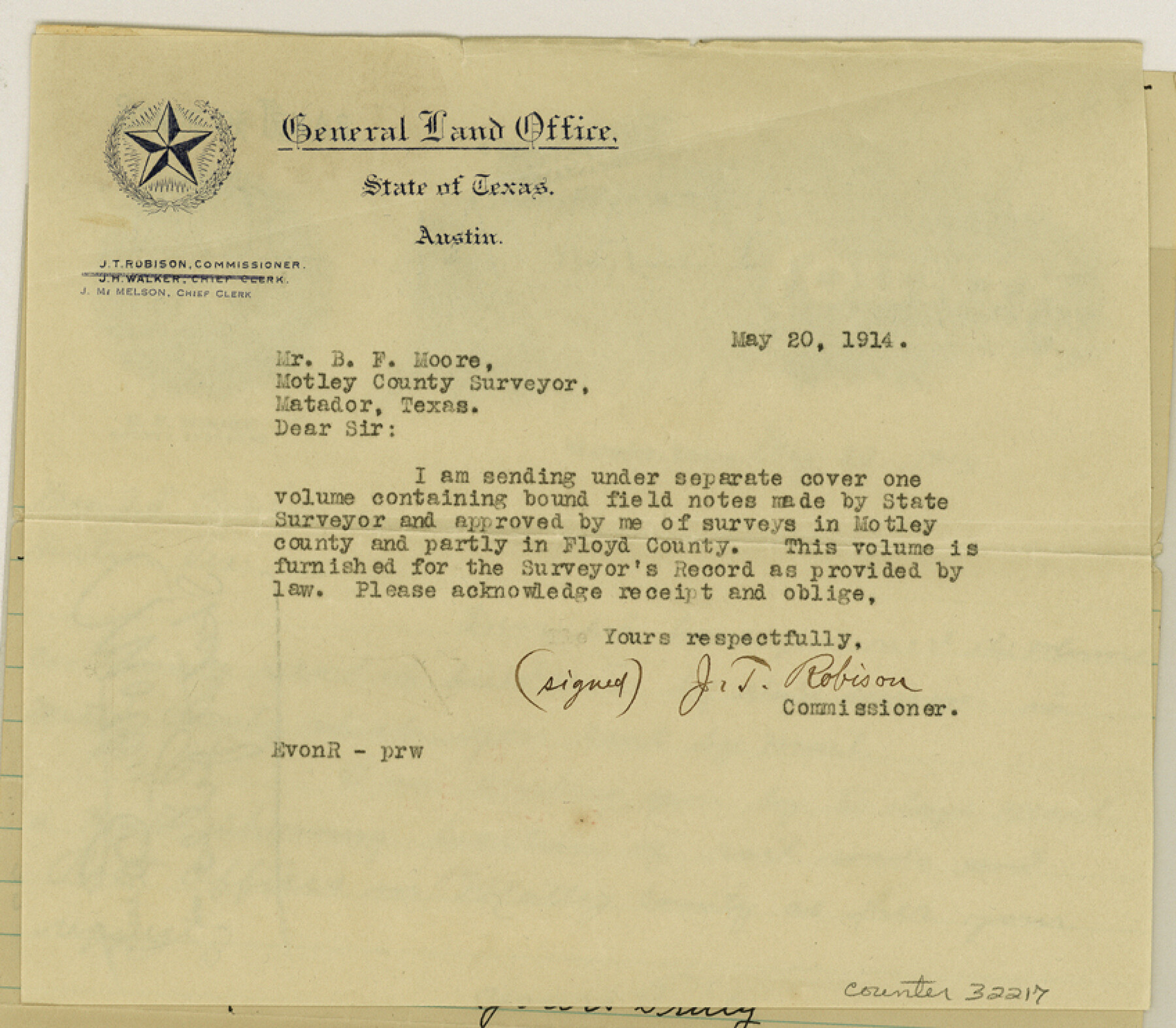
Motley County Sketch File 33 (S)
[Notice of bound volume of field notes sent]
-
Map/Doc
32217
-
Collection
General Map Collection
-
Object Dates
5/20/1914 (Creation Date)
5/20/1914 (Correspondence Date)
5/23/1914 (Correspondence Date)
-
People and Organizations
B.F. Moore (Surveyor/Engineer)
J.T. Robison (GLO Commissioner)
-
Counties
Motley
-
Subjects
Surveying Sketch File
-
Height x Width
7.4 x 8.5 inches
18.8 x 21.6 cm
-
Medium
paper, print
Part of: General Map Collection
Hardin County Sketch File 63

Print $10.00
- Digital $50.00
Hardin County Sketch File 63
Size 11.3 x 8.8 inches
Map/Doc 25238
Presidio County Rolled Sketch 92

Print $20.00
- Digital $50.00
Presidio County Rolled Sketch 92
1947
Size 18.5 x 18.9 inches
Map/Doc 7377
Scarborough's Topographic Map of Massachusetts showing railroads, electric railways, steamboat lines, highways, post offices, villages, etc. completely indexed

Print $40.00
- Digital $50.00
Scarborough's Topographic Map of Massachusetts showing railroads, electric railways, steamboat lines, highways, post offices, villages, etc. completely indexed
1903
Size 39.8 x 59.4 inches
Map/Doc 97107
Coast Chart No. 105 - Galveston Bay to Oyster Bay, Texas

Print $20.00
- Digital $50.00
Coast Chart No. 105 - Galveston Bay to Oyster Bay, Texas
1884
Size 24.3 x 30.1 inches
Map/Doc 69925
Menard County Working Sketch 13

Print $20.00
- Digital $50.00
Menard County Working Sketch 13
1939
Size 27.3 x 38.1 inches
Map/Doc 70960
Gray County Sketch File A

Print $20.00
- Digital $50.00
Gray County Sketch File A
1889
Size 14.2 x 14.6 inches
Map/Doc 24456
Wharton County Rolled Sketch 11

Print $20.00
- Digital $50.00
Wharton County Rolled Sketch 11
Size 27.3 x 37.2 inches
Map/Doc 8235
Rusk County Sketch File 34

Print $20.00
Rusk County Sketch File 34
1949
Size 33.4 x 28.2 inches
Map/Doc 10597
Stonewall County Boundary File 1

Print $34.00
- Digital $50.00
Stonewall County Boundary File 1
Size 9.0 x 8.4 inches
Map/Doc 58938
Upton County Sketch File 17

Print $6.00
- Digital $50.00
Upton County Sketch File 17
Size 11.0 x 10.9 inches
Map/Doc 38875
Kendall County Sketch File 24

Print $8.00
- Digital $50.00
Kendall County Sketch File 24
Size 13.1 x 8.7 inches
Map/Doc 28718
Menard County Sketch File 22

Print $8.00
- Digital $50.00
Menard County Sketch File 22
1927
Size 7.4 x 8.6 inches
Map/Doc 31553
You may also like
Fort Bend County Working Sketch 11

Print $20.00
- Digital $50.00
Fort Bend County Working Sketch 11
1938
Size 33.2 x 29.1 inches
Map/Doc 69217
Flight Mission No. BRA-3M, Frame 194, Jefferson County

Print $20.00
- Digital $50.00
Flight Mission No. BRA-3M, Frame 194, Jefferson County
1953
Size 18.8 x 22.4 inches
Map/Doc 85409
[Surveys in Polk and Chambers Counties]
![355, [Surveys in Polk and Chambers Counties], General Map Collection](https://historictexasmaps.com/wmedia_w700/maps/355.tif.jpg)
Print $3.00
- Digital $50.00
[Surveys in Polk and Chambers Counties]
Size 11.7 x 14.4 inches
Map/Doc 355
Throckmorton County Boundary File 4

Print $6.00
- Digital $50.00
Throckmorton County Boundary File 4
Size 14.3 x 8.8 inches
Map/Doc 59283
Cass County Sketch File 11

Print $6.00
- Digital $50.00
Cass County Sketch File 11
Size 10.4 x 14.4 inches
Map/Doc 17412
Copy of Surveyor's Field Book, Morris Browning - In Blocks 7, 5 & 4, I&GNRRCo., Hutchinson and Carson Counties, Texas

Print $2.00
- Digital $50.00
Copy of Surveyor's Field Book, Morris Browning - In Blocks 7, 5 & 4, I&GNRRCo., Hutchinson and Carson Counties, Texas
1888
Size 7.0 x 8.8 inches
Map/Doc 62284
Erath County Working Sketch 43

Print $20.00
- Digital $50.00
Erath County Working Sketch 43
1981
Size 19.6 x 15.7 inches
Map/Doc 69124
Controlled Mosaic by Jack Amman Photogrammetric Engineers, Inc - Sheet 17

Print $20.00
- Digital $50.00
Controlled Mosaic by Jack Amman Photogrammetric Engineers, Inc - Sheet 17
1954
Size 20.0 x 24.0 inches
Map/Doc 83461
Dimmit County Sketch File 55

Print $20.00
- Digital $50.00
Dimmit County Sketch File 55
1926
Size 23.1 x 15.7 inches
Map/Doc 11359
Menard County Rolled Sketch 17

Print $20.00
- Digital $50.00
Menard County Rolled Sketch 17
1950
Size 23.2 x 26.3 inches
Map/Doc 6763
Upton County Sketch File 40a

Print $40.00
- Digital $50.00
Upton County Sketch File 40a
1963
Size 11.2 x 18.3 inches
Map/Doc 38917
Ward County Working Sketch 38

Print $40.00
- Digital $50.00
Ward County Working Sketch 38
1969
Size 62.2 x 30.3 inches
Map/Doc 72344