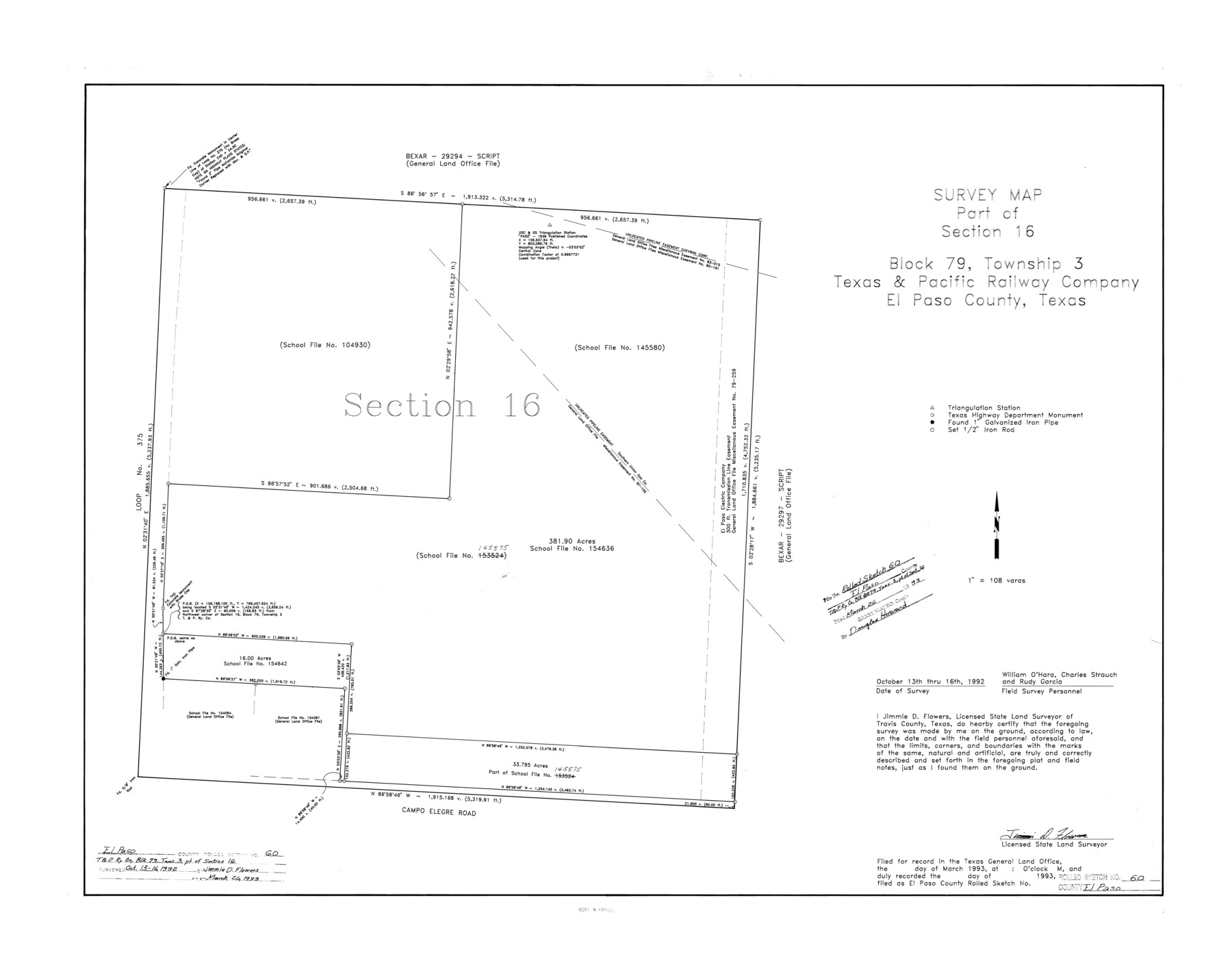
El Paso County Rolled Sketch 60
Survey map part of Section 16, Block 79, Township 3, Texas & Pacific Railway Company
-
Map/Doc
5852
-
Collection
General Map Collection
-
Object Dates
10/16/1992 (Creation Date)
10/13/1992 - 10/16/1992 (Survey Date)
3/26/1993 (File Date)
-
People and Organizations
Jimmie D. Flowers (Surveyor/Engineer)
Charles Strauch (Chainman/Field Personnel)
Rudy Garcia (Chainman/Field Personnel)
Bill O'Hara (Chainman/Field Personnel)
-
Counties
El Paso
-
Subjects
Surveying Rolled Sketch
-
Height x Width
29.0 x 36.5 inches
73.7 x 92.7 cm
-
Medium
mylar, print
-
Scale
1" = 108 varas
Part of: General Map Collection
Parker County Sketch File 7

Print $26.00
- Digital $50.00
Parker County Sketch File 7
1859
Size 12.4 x 7.9 inches
Map/Doc 33533
Archer County Working Sketch Graphic Index

Print $20.00
- Digital $50.00
Archer County Working Sketch Graphic Index
1926
Size 46.7 x 39.4 inches
Map/Doc 76456
Mills County Working Sketch 25

Print $20.00
- Digital $50.00
Mills County Working Sketch 25
1988
Size 22.0 x 25.1 inches
Map/Doc 71055
Presidio County Rolled Sketch 140

Print $20.00
- Digital $50.00
Presidio County Rolled Sketch 140
2003
Size 44.4 x 34.7 inches
Map/Doc 78654
Tyler County Working Sketch 24

Print $20.00
- Digital $50.00
Tyler County Working Sketch 24
1989
Size 34.8 x 40.6 inches
Map/Doc 69494
Kimble County Working Sketch 56

Print $20.00
- Digital $50.00
Kimble County Working Sketch 56
1957
Size 34.6 x 41.9 inches
Map/Doc 70124
Presidio County Sketch File 115

Print $14.00
- Digital $50.00
Presidio County Sketch File 115
1993
Size 11.3 x 8.9 inches
Map/Doc 34835
Right of Way and Track Map, The Missouri, Kansas and Texas Ry. of Texas operated by the Missouri, Kansas and Texas Ry. of Texas, Henrietta Division

Print $40.00
- Digital $50.00
Right of Way and Track Map, The Missouri, Kansas and Texas Ry. of Texas operated by the Missouri, Kansas and Texas Ry. of Texas, Henrietta Division
1918
Size 25.4 x 56.5 inches
Map/Doc 64066
Real County Working Sketch 39

Print $20.00
- Digital $50.00
Real County Working Sketch 39
1951
Size 33.5 x 36.6 inches
Map/Doc 71931
Tom Green County Sketch File 89

Print $4.00
Tom Green County Sketch File 89
Size 14.3 x 8.9 inches
Map/Doc 97245
Flight Mission No. BRE-2P, Frame 125, Nueces County

Print $20.00
- Digital $50.00
Flight Mission No. BRE-2P, Frame 125, Nueces County
1956
Size 18.5 x 22.6 inches
Map/Doc 86801
Pecos County Working Sketch 25
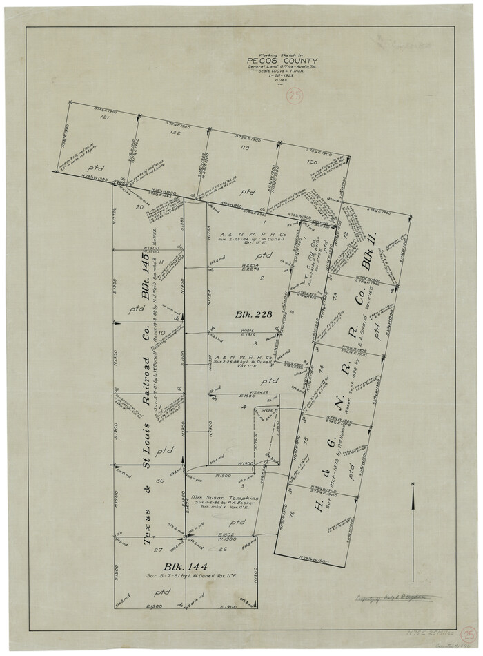
Print $20.00
- Digital $50.00
Pecos County Working Sketch 25
1929
Size 28.9 x 21.1 inches
Map/Doc 71496
You may also like
Walker County State Real Property Sketch 1

Print $20.00
- Digital $50.00
Walker County State Real Property Sketch 1
2003
Size 35.8 x 30.3 inches
Map/Doc 78585
San Patricio County Working Sketch 2

Print $20.00
- Digital $50.00
San Patricio County Working Sketch 2
1911
Size 18.6 x 15.1 inches
Map/Doc 63764
[Southwest part of County]
![90922, [Southwest part of County], Twichell Survey Records](https://historictexasmaps.com/wmedia_w700/maps/90922-1.tif.jpg)
Print $20.00
- Digital $50.00
[Southwest part of County]
Size 28.8 x 18.4 inches
Map/Doc 90922
[Southeast part of Stephens County]
![91844, [Southeast part of Stephens County], Twichell Survey Records](https://historictexasmaps.com/wmedia_w700/maps/91844-1.tif.jpg)
Print $20.00
- Digital $50.00
[Southeast part of Stephens County]
Size 37.2 x 32.7 inches
Map/Doc 91844
Map of certain tidal areas in Harris and Galveston Counties showing subdivision thereof for mineral development

Print $20.00
- Digital $50.00
Map of certain tidal areas in Harris and Galveston Counties showing subdivision thereof for mineral development
1938
Size 34.3 x 26.7 inches
Map/Doc 2936
Terrell County Working Sketch 1

Print $20.00
- Digital $50.00
Terrell County Working Sketch 1
1886
Size 27.5 x 24.4 inches
Map/Doc 62149
Brewster County Working Sketch 7

Print $20.00
- Digital $50.00
Brewster County Working Sketch 7
1909
Size 39.9 x 17.1 inches
Map/Doc 67540
Upton County Working Sketch 18

Print $20.00
- Digital $50.00
Upton County Working Sketch 18
1945
Size 19.7 x 19.9 inches
Map/Doc 69514
Current Miscellaneous File 27

Print $4.00
- Digital $50.00
Current Miscellaneous File 27
1952
Size 10.8 x 8.3 inches
Map/Doc 73909
Flight Mission No. DQN-2K, Frame 137, Calhoun County

Print $20.00
- Digital $50.00
Flight Mission No. DQN-2K, Frame 137, Calhoun County
1953
Size 18.8 x 22.5 inches
Map/Doc 84306
Sectional map of Texas traversed by the Missouri, Kansas & Texas Railway, showing the crops adapted to each section, with the elevation and annual rainfall

Print $20.00
- Digital $50.00
Sectional map of Texas traversed by the Missouri, Kansas & Texas Railway, showing the crops adapted to each section, with the elevation and annual rainfall
1908
Size 22.0 x 22.9 inches
Map/Doc 95816
Flight Mission No. DIX-8P, Frame 75, Aransas County

Print $20.00
- Digital $50.00
Flight Mission No. DIX-8P, Frame 75, Aransas County
1956
Size 18.9 x 22.3 inches
Map/Doc 83906