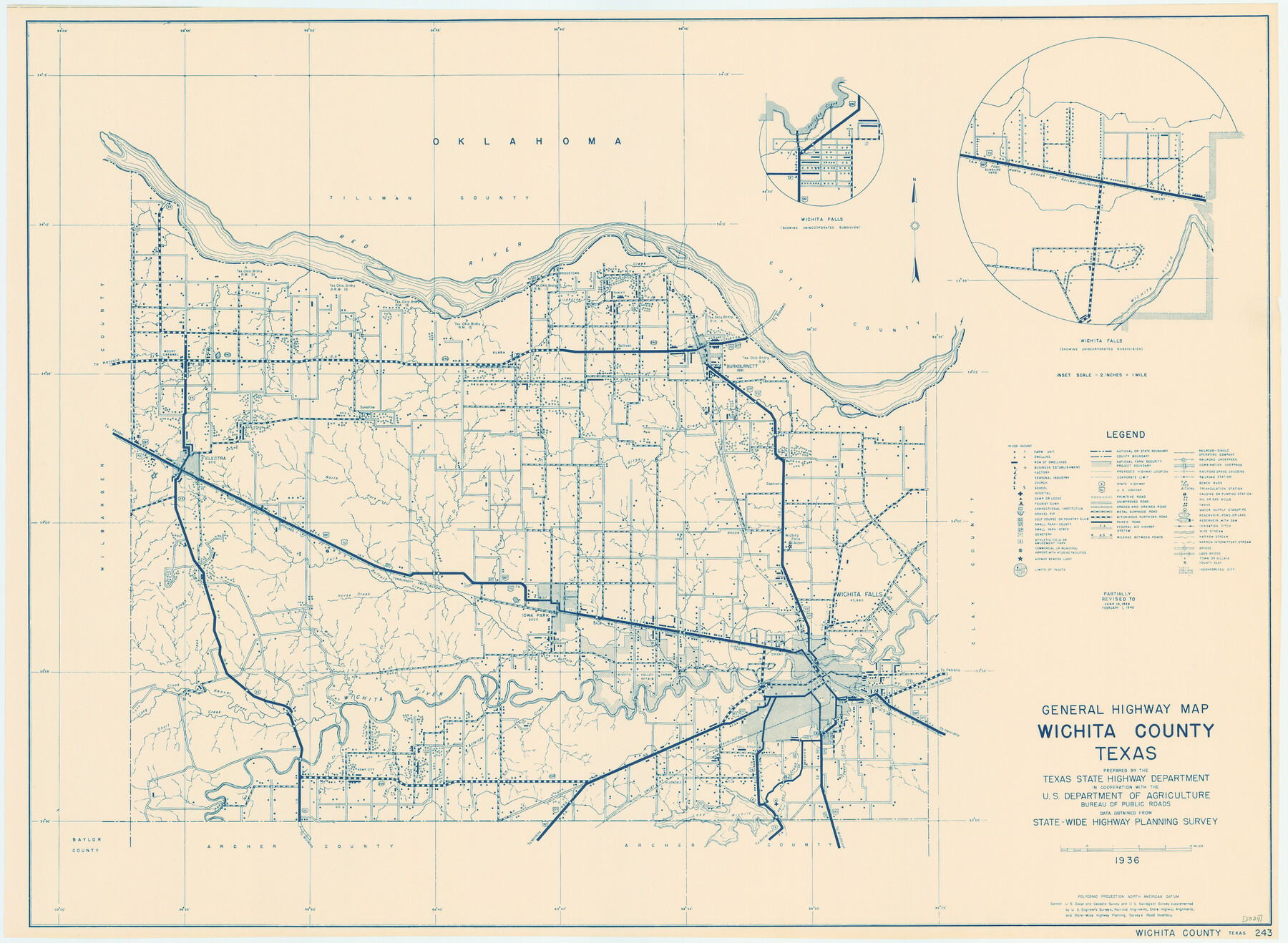
General Highway Map, Wichita County, Texas
-
Map/Doc
79277
-
Collection
Texas State Library and Archives
-
Object Dates
1940 (Creation Date)
-
People and Organizations
Texas State Highway Department (Publisher)
-
Counties
Wichita
-
Subjects
County
-
Height x Width
18.1 x 24.8 inches
46.0 x 63.0 cm
-
Comments
Prints available courtesy of the Texas State Library and Archives.
More info can be found here: TSLAC Map 05024
Part of: Texas State Library and Archives
General Highway Map, McLennan County, Texas

Print $20.00
General Highway Map, McLennan County, Texas
1940
Size 18.3 x 24.6 inches
Map/Doc 79191
A Map of the Internal Provinces of New Spain

Print $20.00
A Map of the Internal Provinces of New Spain
1807
Size 18.9 x 19.5 inches
Map/Doc 76234
General Highway Map, Colorado County, Texas

Print $20.00
General Highway Map, Colorado County, Texas
1961
Size 25.1 x 18.3 inches
Map/Doc 79416
General Highway Map, Schleicher County, Sutton County, Texas

Print $20.00
General Highway Map, Schleicher County, Sutton County, Texas
1940
Size 18.3 x 25.0 inches
Map/Doc 79239
General Highway Map. Detail of Cities and Towns in Harris County, Texas. City Map [of] Houston, Pasadena, West University Place, Bellaire, Galena Park, Jacinto City, South Houston, South Side Place, Deer Park, and vicinity, Harris County, Texas
![79504, General Highway Map. Detail of Cities and Towns in Harris County, Texas. City Map [of] Houston, Pasadena, West University Place, Bellaire, Galena Park, Jacinto City, South Houston, South Side Place, Deer Park, and vicinity, Harris County, Texas, Texas State Library and Archives](https://historictexasmaps.com/wmedia_w700/maps/79504.tif.jpg)
Print $20.00
General Highway Map. Detail of Cities and Towns in Harris County, Texas. City Map [of] Houston, Pasadena, West University Place, Bellaire, Galena Park, Jacinto City, South Houston, South Side Place, Deer Park, and vicinity, Harris County, Texas
1961
Size 18.1 x 24.8 inches
Map/Doc 79504
Magnolia Road Map of Texas

Print $20.00
Magnolia Road Map of Texas
1933
Size 18.1 x 24.1 inches
Map/Doc 76301
General Highway Map, Victoria County, Texas

Print $20.00
General Highway Map, Victoria County, Texas
1961
Size 25.0 x 18.3 inches
Map/Doc 79697
Map Showing Colonel A.W. Doniphan's Route through the States of New Mexico, Chihuahua and Coahuila

Print $20.00
Map Showing Colonel A.W. Doniphan's Route through the States of New Mexico, Chihuahua and Coahuila
1847
Size 16.9 x 14.0 inches
Map/Doc 79729
General Highway Map. Detail of Cities and Towns in Travis County, Texas. City Map, Austin and vicinity, Travis County, Texas

Print $20.00
General Highway Map. Detail of Cities and Towns in Travis County, Texas. City Map, Austin and vicinity, Travis County, Texas
1961
Size 24.8 x 18.1 inches
Map/Doc 79686
General Highway Map, Burleson County, Texas

Print $20.00
General Highway Map, Burleson County, Texas
1961
Size 18.1 x 24.8 inches
Map/Doc 79391
Preliminary Chart of the Entrance to Matagorda Bay, Texas

Print $20.00
Preliminary Chart of the Entrance to Matagorda Bay, Texas
1857
Size 20.2 x 32.9 inches
Map/Doc 76247
General Highway Map, Brewster County, Texas

Print $20.00
General Highway Map, Brewster County, Texas
1961
Size 18.2 x 24.9 inches
Map/Doc 79385
You may also like
Terrell County Working Sketch 51

Print $40.00
- Digital $50.00
Terrell County Working Sketch 51
1958
Size 63.7 x 43.6 inches
Map/Doc 62144
Crockett County Sketch File 67

Print $20.00
- Digital $50.00
Crockett County Sketch File 67
1927
Size 30.1 x 26.6 inches
Map/Doc 11231
Wilbarger County Working Sketch 21

Print $20.00
- Digital $50.00
Wilbarger County Working Sketch 21
1979
Size 37.4 x 37.8 inches
Map/Doc 72559
Map of the Northwest Portion of Hutchinson County Showing the Proposed Resurvey of Block M24

Print $20.00
- Digital $50.00
Map of the Northwest Portion of Hutchinson County Showing the Proposed Resurvey of Block M24
Size 32.4 x 30.1 inches
Map/Doc 91237
Flight Mission No. DAG-24K, Frame 53, Matagorda County

Print $20.00
- Digital $50.00
Flight Mission No. DAG-24K, Frame 53, Matagorda County
1953
Size 18.5 x 22.3 inches
Map/Doc 86540
General Highway Map, Yoakum County Texas

Print $20.00
- Digital $50.00
General Highway Map, Yoakum County Texas
1952
Size 26.3 x 19.1 inches
Map/Doc 92815
San Augustine County Sketch File 19

Print $23.00
San Augustine County Sketch File 19
Size 14.8 x 14.2 inches
Map/Doc 35678
North Sulphur River, Sims Crossing Sheet

Print $20.00
- Digital $50.00
North Sulphur River, Sims Crossing Sheet
1924
Size 12.4 x 25.1 inches
Map/Doc 78335
Edwards County Rolled Sketch 16A

Print $20.00
- Digital $50.00
Edwards County Rolled Sketch 16A
1944
Size 25.0 x 19.0 inches
Map/Doc 5805
Real County Working Sketch 77

Print $20.00
- Digital $50.00
Real County Working Sketch 77
1980
Size 33.1 x 33.3 inches
Map/Doc 71969
Brazos Island Harbor, Texas - Dredging Entrance Channel Plan

Print $20.00
- Digital $50.00
Brazos Island Harbor, Texas - Dredging Entrance Channel Plan
1990
Size 14.5 x 20.1 inches
Map/Doc 83338
Layout of the porciones as described in the Visita General of Reynosa, 1767

Layout of the porciones as described in the Visita General of Reynosa, 1767
2009
Size 11.0 x 8.5 inches
Map/Doc 94045