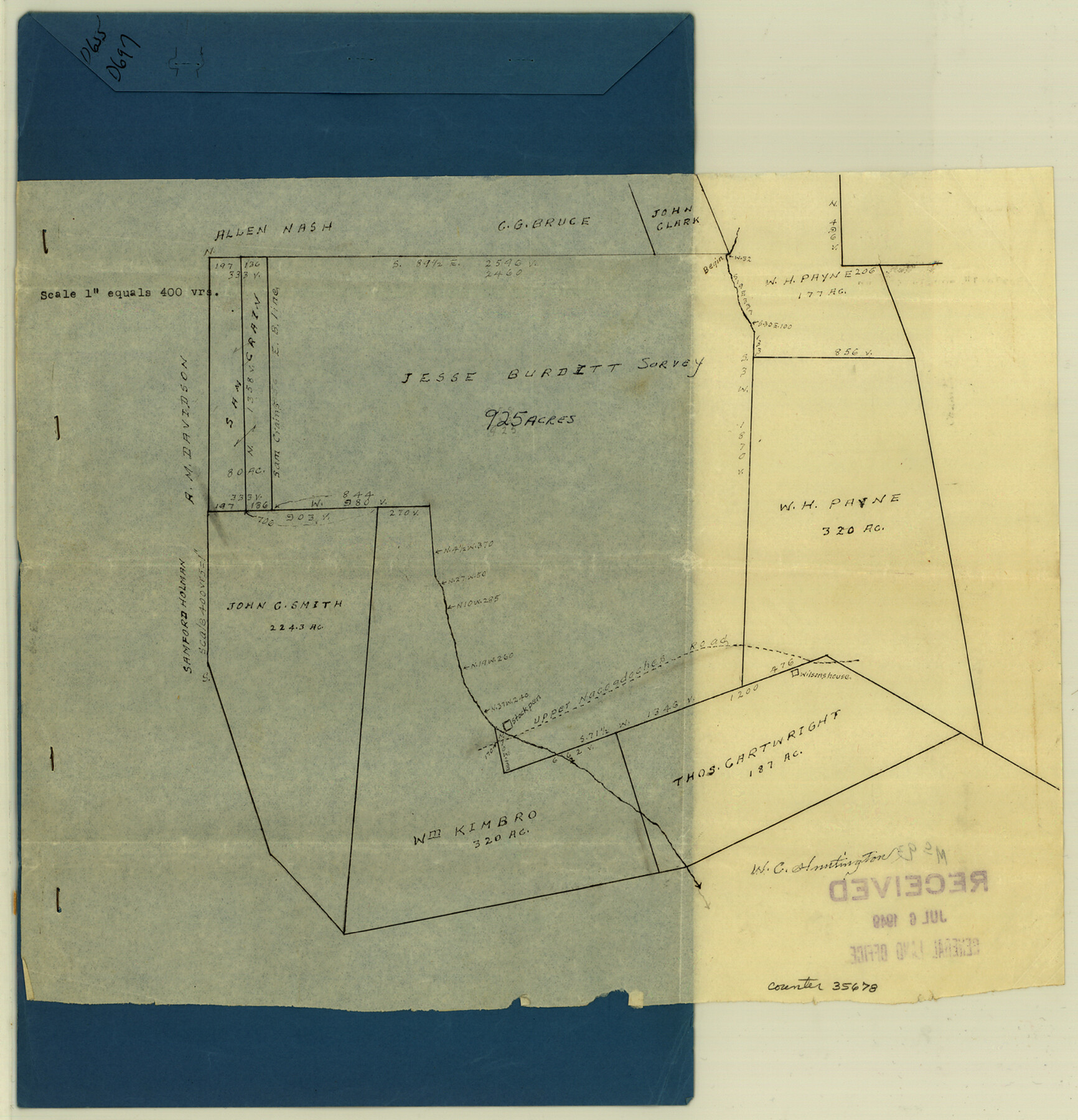
San Augustine County Sketch File 19
[Sketch of the Jesse Burditt survey]
-
Map/Doc
35678
-
Collection
General Map Collection
-
Object Dates
7/13/1949 (File Date)
-
People and Organizations
W.C. Huntington (Surveyor/Engineer)
-
Counties
San Augustine
-
Subjects
Surveying Sketch File
-
Height x Width
14.8 x 14.2 inches
37.6 x 36.1 cm
-
Medium
paper, manuscript
-
Scale
1" = 400 varas
-
Features
Upper Nacogdoches Road
Wilson's House
Part of: General Map Collection
Gaines County Rolled Sketch 6

Print $20.00
- Digital $50.00
Gaines County Rolled Sketch 6
1913
Size 30.5 x 45.4 inches
Map/Doc 5927
Hays County Working Sketch 2

Print $20.00
- Digital $50.00
Hays County Working Sketch 2
1920
Size 26.1 x 27.1 inches
Map/Doc 66076
Jones County Sketch File 5a

Print $20.00
- Digital $50.00
Jones County Sketch File 5a
1857
Size 18.4 x 23.5 inches
Map/Doc 11896
Hopkins County Boundary File 3

Print $46.00
- Digital $50.00
Hopkins County Boundary File 3
Size 8.2 x 3.8 inches
Map/Doc 55059
Webb County Sketch File 25

Print $20.00
- Digital $50.00
Webb County Sketch File 25
1936
Size 18.2 x 30.7 inches
Map/Doc 12639
Lamb County Boundary File 4

Print $16.00
- Digital $50.00
Lamb County Boundary File 4
Size 11.3 x 8.7 inches
Map/Doc 56084
Briscoe County Boundary File 5

Print $4.00
Briscoe County Boundary File 5
1894
Size 10.6 x 8.1 inches
Map/Doc 50802
Kimble County Sketch File 17

Print $17.00
- Digital $50.00
Kimble County Sketch File 17
Size 11.5 x 8.5 inches
Map/Doc 28947
Milam County Sketch File 2

Print $4.00
- Digital $50.00
Milam County Sketch File 2
1849
Size 8.0 x 12.4 inches
Map/Doc 31627
[Galveston, Harrisburg & San Antonio through El Paso County]
![64003, [Galveston, Harrisburg & San Antonio through El Paso County], General Map Collection](https://historictexasmaps.com/wmedia_w700/maps/64003.tif.jpg)
Print $20.00
- Digital $50.00
[Galveston, Harrisburg & San Antonio through El Paso County]
1907
Size 13.7 x 33.9 inches
Map/Doc 64003
Laguna Madre, T-9212

Print $20.00
- Digital $50.00
Laguna Madre, T-9212
Size 33.1 x 31.4 inches
Map/Doc 73603
Railroad Track Map, H&TCRRCo., Falls County, Texas

Print $4.00
- Digital $50.00
Railroad Track Map, H&TCRRCo., Falls County, Texas
1918
Size 11.6 x 18.6 inches
Map/Doc 62848
You may also like
The Republic County of San Augustine. Boundaries Defined, December 14, 1837

Print $20.00
The Republic County of San Augustine. Boundaries Defined, December 14, 1837
2020
Size 18.8 x 21.7 inches
Map/Doc 96271
Rains County Working Sketch 10

Print $20.00
- Digital $50.00
Rains County Working Sketch 10
1998
Size 36.1 x 34.7 inches
Map/Doc 71836
Cochran County Boundary File 2

Print $59.00
- Digital $50.00
Cochran County Boundary File 2
Size 14.8 x 9.3 inches
Map/Doc 51466
The Republic County of Brazoria. May 15, 1838

Print $20.00
The Republic County of Brazoria. May 15, 1838
2020
Size 14.7 x 21.8 inches
Map/Doc 96112
Hutchinson County Working Sketch 24

Print $20.00
- Digital $50.00
Hutchinson County Working Sketch 24
1967
Size 27.2 x 40.0 inches
Map/Doc 66384
Brewster County Working Sketch 90

Print $40.00
- Digital $50.00
Brewster County Working Sketch 90
1975
Size 61.0 x 43.3 inches
Map/Doc 67690
Pecos County Rolled Sketch 142

Print $20.00
- Digital $50.00
Pecos County Rolled Sketch 142
Size 26.9 x 41.9 inches
Map/Doc 7276
San Jacinto County Sketch File 11

Print $4.00
San Jacinto County Sketch File 11
1859
Size 9.4 x 7.3 inches
Map/Doc 35718
Flight Mission No. DQO-8K, Frame 42, Galveston County

Print $20.00
- Digital $50.00
Flight Mission No. DQO-8K, Frame 42, Galveston County
1952
Size 18.5 x 22.3 inches
Map/Doc 85149
The Castro Colony. February 15, 1842

Print $20.00
The Castro Colony. February 15, 1842
2020
Size 23.0 x 17.7 inches
Map/Doc 96357
[Leagues 247, 320, and 321]
![91291, [Leagues 247, 320, and 321], Twichell Survey Records](https://historictexasmaps.com/wmedia_w700/maps/91291-1.tif.jpg)
Print $2.00
- Digital $50.00
[Leagues 247, 320, and 321]
Size 8.2 x 15.1 inches
Map/Doc 91291
Map of Kaufman and Rockwall Counties, Texas

Print $20.00
Map of Kaufman and Rockwall Counties, Texas
1878
Size 23.4 x 17.3 inches
Map/Doc 88963