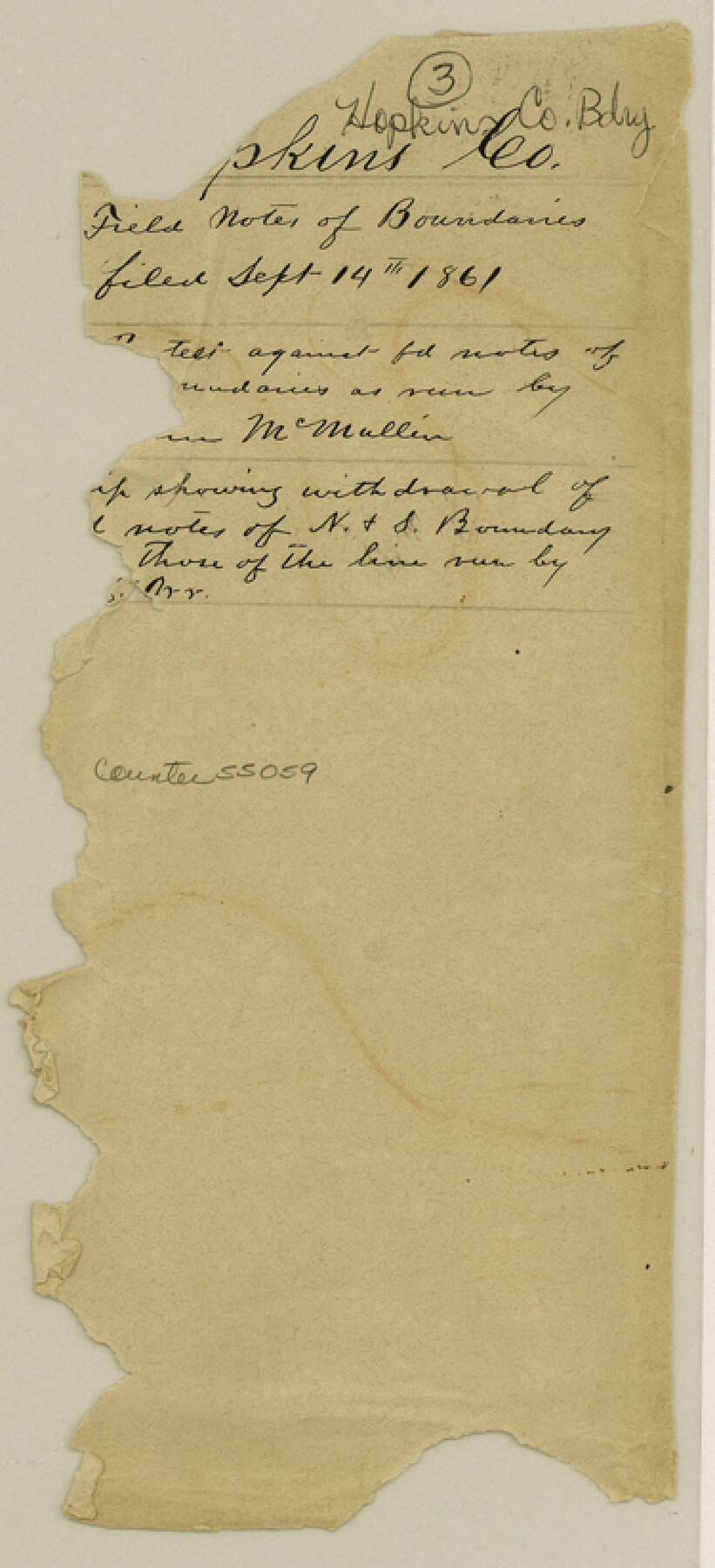
Hopkins County Boundary File 3
Field Notes of Boundary line between Wood & Hopkins County
-
Map/Doc
55059
-
Collection
General Map Collection
-
Counties
Hopkins
-
Subjects
County Boundaries
-
Height x Width
8.2 x 3.8 inches
20.8 x 9.7 cm
Part of: General Map Collection
Pecos County Working Sketch 108

Print $40.00
- Digital $50.00
Pecos County Working Sketch 108
1971
Size 43.5 x 56.3 inches
Map/Doc 71581

United States - Gulf Coast - From Latitude 26° 33' to the Rio Grande Texas

Print $20.00
- Digital $50.00
United States - Gulf Coast - From Latitude 26° 33' to the Rio Grande Texas
1913
Size 18.5 x 27.6 inches
Map/Doc 72841
Duval County Boundary File 3i

Print $4.00
- Digital $50.00
Duval County Boundary File 3i
Size 8.3 x 10.3 inches
Map/Doc 52751
Martin County Rolled Sketch 6

Print $20.00
- Digital $50.00
Martin County Rolled Sketch 6
Size 25.8 x 26.9 inches
Map/Doc 6666
Flight Mission No. DQO-3K, Frame 31, Galveston County

Print $20.00
- Digital $50.00
Flight Mission No. DQO-3K, Frame 31, Galveston County
1952
Size 18.9 x 22.5 inches
Map/Doc 85072
Carson County Sketch File 2

Print $20.00
- Digital $50.00
Carson County Sketch File 2
1888
Size 19.5 x 21.1 inches
Map/Doc 11054
Map of Polk County

Print $20.00
- Digital $50.00
Map of Polk County
1881
Size 25.7 x 21.1 inches
Map/Doc 3962
Atascosa County Working Sketch 2

Print $20.00
- Digital $50.00
Atascosa County Working Sketch 2
1910
Size 23.5 x 33.2 inches
Map/Doc 67197
Laguna Madre from Lone Palmetto Triangulation Station to Gum Pen Triangulation Station

Print $20.00
- Digital $50.00
Laguna Madre from Lone Palmetto Triangulation Station to Gum Pen Triangulation Station
1881
Size 16.2 x 27.5 inches
Map/Doc 73497
Houston County Sketch File 31

Print $2.00
- Digital $50.00
Houston County Sketch File 31
1888
Size 9.1 x 7.9 inches
Map/Doc 26808
Map of the Surveyed Part of Young District

Print $40.00
- Digital $50.00
Map of the Surveyed Part of Young District
1860
Size 56.3 x 32.6 inches
Map/Doc 87373
You may also like
Newton County Sketch File 4b

Print $22.00
- Digital $50.00
Newton County Sketch File 4b
Size 7.6 x 12.2 inches
Map/Doc 32364
Rusk County Sketch File 39

Print $6.00
Rusk County Sketch File 39
1951
Size 11.3 x 8.9 inches
Map/Doc 35579
Young County Working Sketch 9

Print $20.00
- Digital $50.00
Young County Working Sketch 9
1921
Size 25.9 x 36.6 inches
Map/Doc 62032
Hansford County Sketch File 10

Print $6.00
- Digital $50.00
Hansford County Sketch File 10
1931
Size 8.2 x 8.5 inches
Map/Doc 24969
Archer County Sketch File C

Print $164.00
- Digital $50.00
Archer County Sketch File C
1899
Size 9.0 x 6.2 inches
Map/Doc 13574
[Sketch for Mineral Application 33721 - 33725 Incl. - Padre and Mustang Island]
![2870, [Sketch for Mineral Application 33721 - 33725 Incl. - Padre and Mustang Island], General Map Collection](https://historictexasmaps.com/wmedia_w700/maps/2870.tif.jpg)
Print $20.00
- Digital $50.00
[Sketch for Mineral Application 33721 - 33725 Incl. - Padre and Mustang Island]
1942
Size 22.1 x 22.4 inches
Map/Doc 2870
Webb County Rolled Sketch 37

Print $20.00
- Digital $50.00
Webb County Rolled Sketch 37
1940
Size 43.0 x 19.2 inches
Map/Doc 8192
Dickens County Sketch File G2

Print $26.00
- Digital $50.00
Dickens County Sketch File G2
1914
Size 11.4 x 8.9 inches
Map/Doc 20858
Flight Mission No. BRA-16M, Frame 69, Jefferson County

Print $20.00
- Digital $50.00
Flight Mission No. BRA-16M, Frame 69, Jefferson County
1953
Size 18.6 x 22.2 inches
Map/Doc 85686
Flight Mission No. DCL-7C, Frame 138, Kenedy County

Print $20.00
- Digital $50.00
Flight Mission No. DCL-7C, Frame 138, Kenedy County
1943
Size 18.6 x 22.3 inches
Map/Doc 86095
Cooke County Boundary File 1b

Print $28.00
- Digital $50.00
Cooke County Boundary File 1b
Size 12.6 x 7.4 inches
Map/Doc 51835
General Highway Map, Terrell County, Texas

Print $20.00
General Highway Map, Terrell County, Texas
1961
Size 24.9 x 18.2 inches
Map/Doc 79674