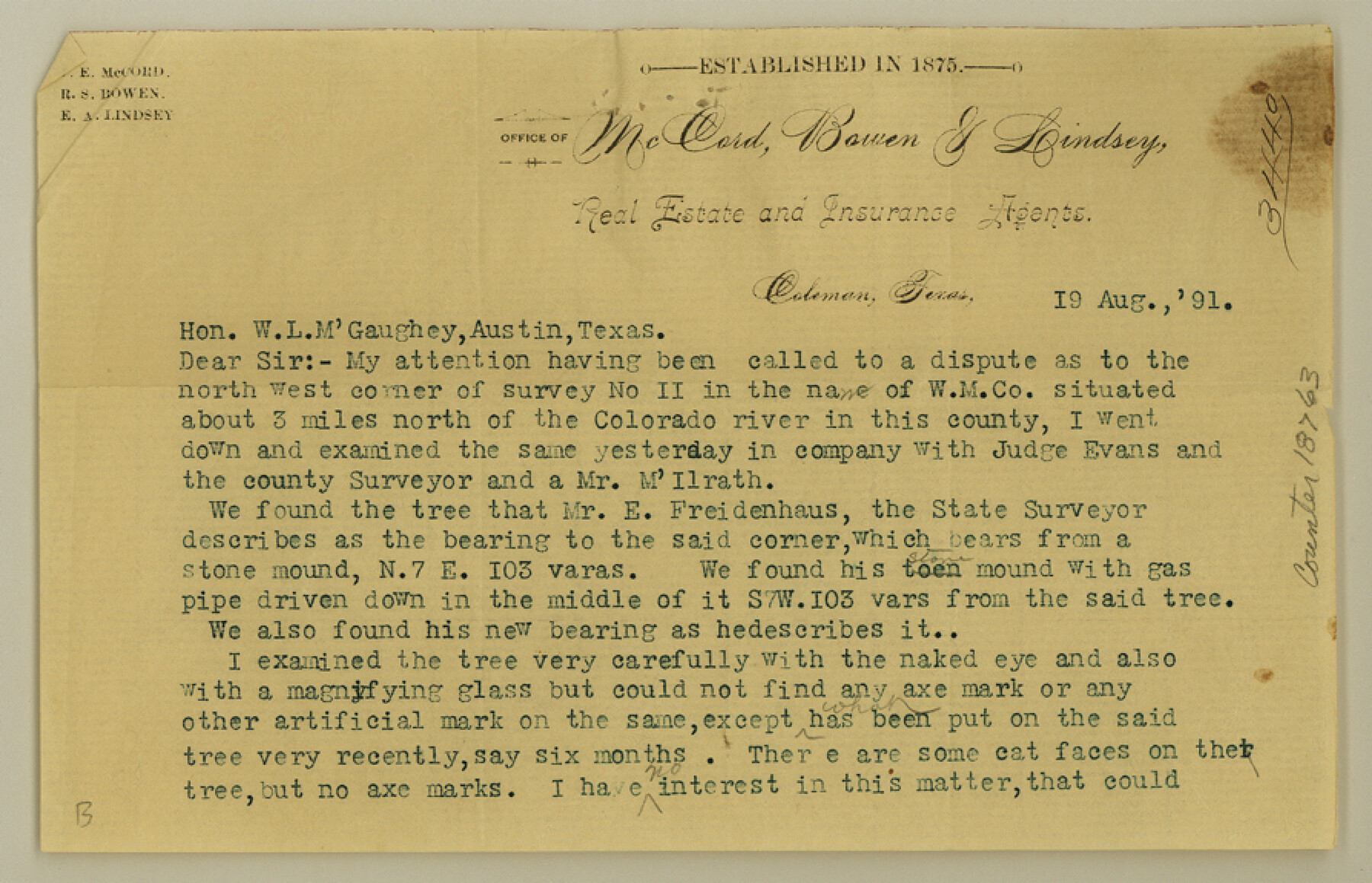
Coleman County Sketch File 42
[Statements, protest, and affidavit regarding lands in south part of Coleman County]
-
Map/Doc
18763
-
Collection
General Map Collection
-
Object Dates
1891/8/11 (Creation Date)
1891/7/9 (Creation Date)
1891/7/11 (Creation Date)
1891/7/13 (File Date)
1891/8/19 (Creation Date)
1891/8/21 (File Date)
1891/5/11 (File Date)
1891/7/14 (File Date)
-
People and Organizations
R.S. Bowen (Surveyor/Engineer)
E. Freidenhaus (Surveyor/Engineer)
J.T. Evans (Surveyor/Engineer)
J.A. McElrath (Surveyor/Engineer)
-
Counties
Coleman
-
Subjects
Surveying Sketch File
-
Height x Width
5.8 x 8.9 inches
14.7 x 22.6 cm
-
Medium
multi-page, multi-format
-
Features
Colorado River
Part of: General Map Collection
Dallam County Working Sketch Graphic Index

Print $40.00
- Digital $50.00
Dallam County Working Sketch Graphic Index
1926
Size 41.3 x 50.9 inches
Map/Doc 76516
Travis County Appraisal District Plat Map 3_0721

Print $20.00
- Digital $50.00
Travis County Appraisal District Plat Map 3_0721
Size 21.5 x 26.3 inches
Map/Doc 94227
Kleberg County Rolled Sketch 10-25

Print $20.00
- Digital $50.00
Kleberg County Rolled Sketch 10-25
1952
Size 38.1 x 35.8 inches
Map/Doc 9365
Hardeman County Sketch File A2

Print $20.00
- Digital $50.00
Hardeman County Sketch File A2
Size 28.5 x 17.3 inches
Map/Doc 11631
Flight Mission No. DQN-5K, Frame 141, Calhoun County

Print $20.00
- Digital $50.00
Flight Mission No. DQN-5K, Frame 141, Calhoun County
1953
Size 18.7 x 21.9 inches
Map/Doc 84416
Stieler Map of 1879

Print $4.00
- Digital $50.00
Stieler Map of 1879
1879
Size 28.9 x 23.0 inches
Map/Doc 76055
Lavaca County Rolled Sketch 5

Print $40.00
- Digital $50.00
Lavaca County Rolled Sketch 5
Size 37.0 x 49.1 inches
Map/Doc 10288
![4828, [San Diego], General Map Collection](https://historictexasmaps.com/wmedia_w700/maps/4828-1.tif.jpg)
Uvalde County Sketch File 16

Print $14.00
- Digital $50.00
Uvalde County Sketch File 16
1876
Size 12.8 x 8.4 inches
Map/Doc 38988
Tarrant County Sketch File 21a

Print $4.00
- Digital $50.00
Tarrant County Sketch File 21a
1859
Size 8.0 x 8.1 inches
Map/Doc 37727
Chart of the West Indies and Spanish Dominions in North America

Print $20.00
- Digital $50.00
Chart of the West Indies and Spanish Dominions in North America
1803
Size 25.7 x 39.4 inches
Map/Doc 97137
Stephens County Sketch File 15

Print $4.00
- Digital $50.00
Stephens County Sketch File 15
1890
Size 9.1 x 6.7 inches
Map/Doc 37068
You may also like
Carter Estate, North Half 77, Block A, Lubbock County

Print $20.00
- Digital $50.00
Carter Estate, North Half 77, Block A, Lubbock County
1941
Size 9.8 x 18.4 inches
Map/Doc 92751
Orange County Rolled Sketch 13

Print $20.00
- Digital $50.00
Orange County Rolled Sketch 13
Size 19.0 x 24.2 inches
Map/Doc 7180
Robertson County Working Sketch 2

Print $20.00
- Digital $50.00
Robertson County Working Sketch 2
1939
Size 14.5 x 16.3 inches
Map/Doc 63575
Right of Way and Track Map, International & Gt. Northern Ry. Operated by the International & Gt. Northern Ry. Co., Gulf Division

Print $40.00
- Digital $50.00
Right of Way and Track Map, International & Gt. Northern Ry. Operated by the International & Gt. Northern Ry. Co., Gulf Division
1917
Size 25.1 x 56.6 inches
Map/Doc 64252
Crosby County School Land, Lamb and Bailey Counties

Print $20.00
- Digital $50.00
Crosby County School Land, Lamb and Bailey Counties
Size 12.4 x 14.9 inches
Map/Doc 90109
The Republic County of Red River. December 29, 1845

Print $20.00
The Republic County of Red River. December 29, 1845
2020
Size 21.0 x 21.7 inches
Map/Doc 96255
General Highway Map, Hardeman County, Texas

Print $20.00
General Highway Map, Hardeman County, Texas
1961
Size 24.6 x 18.1 inches
Map/Doc 79498
Nueces County Rolled Sketch 126

Print $20.00
- Digital $50.00
Nueces County Rolled Sketch 126
1998
Size 24.5 x 36.8 inches
Map/Doc 7161
Hutchinson County Rolled Sketch 38

Print $40.00
- Digital $50.00
Hutchinson County Rolled Sketch 38
1955
Size 43.6 x 67.7 inches
Map/Doc 9248
Flight Mission No. BRE-1P, Frame 125, Nueces County

Print $20.00
- Digital $50.00
Flight Mission No. BRE-1P, Frame 125, Nueces County
1956
Size 18.6 x 22.7 inches
Map/Doc 86691
Lamar County Sketch File 10

Print $4.00
- Digital $50.00
Lamar County Sketch File 10
1872
Size 8.1 x 9.9 inches
Map/Doc 29293
McLennan County Sketch File 40

Print $8.00
- Digital $50.00
McLennan County Sketch File 40
1950
Size 14.2 x 8.7 inches
Map/Doc 31315