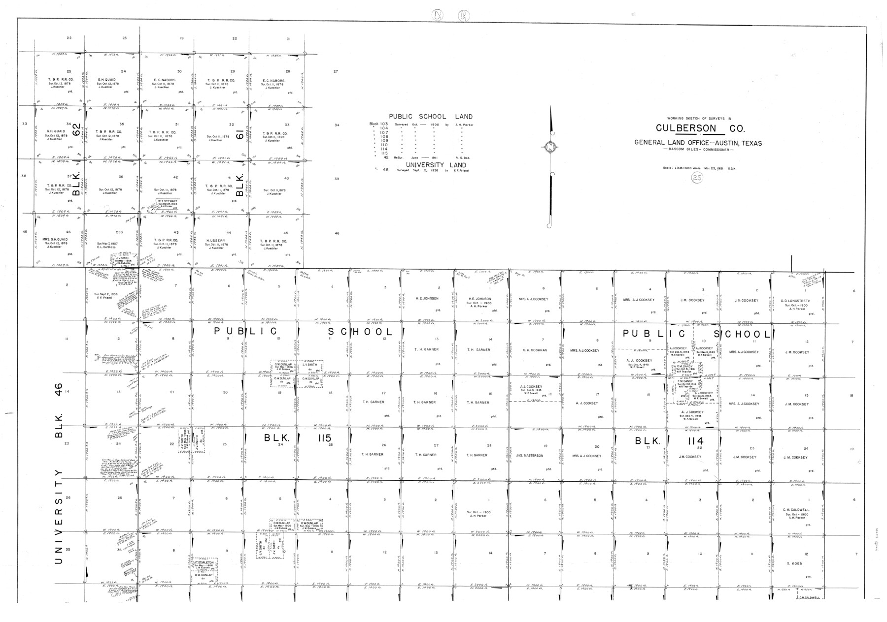
Culberson County Working Sketch 25
-
Map/Doc
62343
-
Collection
General Map Collection
-
Object Dates
3/23/1951 (Creation Date)
-
People and Organizations
Otto G. Kurio (Draftsman)
-
Counties
Culberson
-
Subjects
Surveying Working Sketch
-
Height x Width
36.9 x 52.5 inches
93.7 x 133.4 cm
-
Scale
1" = 600 varas
-
Comments
Segment 1; for segment 2 see counter No. 68478.
Related maps
Culberson County Working Sketch 25

Print $40.00
- Digital $50.00
Culberson County Working Sketch 25
1951
Size 30.5 x 52.9 inches
Map/Doc 68478
Part of: General Map Collection
Harris County Historic Topographic 34

Print $20.00
- Digital $50.00
Harris County Historic Topographic 34
1915
Size 19.7 x 23.7 inches
Map/Doc 65845
Rusk County Sketch File 47

Print $8.00
Rusk County Sketch File 47
Size 12.7 x 7.9 inches
Map/Doc 35597
Central Part of Jeff Davis Co.

Print $40.00
- Digital $50.00
Central Part of Jeff Davis Co.
1982
Size 54.2 x 41.6 inches
Map/Doc 77326
Oldham County Boundary File 3

Print $80.00
- Digital $50.00
Oldham County Boundary File 3
Size 20.0 x 58.0 inches
Map/Doc 57771
Haskell County Sketch File 5

Print $4.00
- Digital $50.00
Haskell County Sketch File 5
1856
Size 10.1 x 8.1 inches
Map/Doc 26124
Galveston County Sketch File 35

Print $8.00
- Digital $50.00
Galveston County Sketch File 35
1934
Size 11.3 x 8.8 inches
Map/Doc 23419
Coleman County Working Sketch 2

Print $20.00
- Digital $50.00
Coleman County Working Sketch 2
1917
Size 15.0 x 16.8 inches
Map/Doc 68068
Dickens County Sketch File 36

Print $4.00
- Digital $50.00
Dickens County Sketch File 36
1891
Size 11.3 x 9.1 inches
Map/Doc 21042
United States Gulf Coast - from Galveston to the Rio Grande

Print $20.00
- Digital $50.00
United States Gulf Coast - from Galveston to the Rio Grande
1915
Size 26.3 x 18.3 inches
Map/Doc 72731
Orange County Working Sketch 8

Print $20.00
- Digital $50.00
Orange County Working Sketch 8
1922
Size 20.7 x 24.3 inches
Map/Doc 71340
Rockwall County Boundary File 10

Print $40.00
- Digital $50.00
Rockwall County Boundary File 10
Size 14.0 x 8.9 inches
Map/Doc 58439
Comal County Working Sketch 14

Print $40.00
- Digital $50.00
Comal County Working Sketch 14
1992
Size 25.4 x 49.9 inches
Map/Doc 68180
You may also like
Baffin Bay, Texas from Penescal Triangulation Station to Bovido Triangulation Station

Print $40.00
- Digital $50.00
Baffin Bay, Texas from Penescal Triangulation Station to Bovido Triangulation Station
1881
Size 32.6 x 54.2 inches
Map/Doc 73484
Block 39 of the Brown Subdivision being a part of the Northeast Quarter Section 4, Block O

Print $20.00
- Digital $50.00
Block 39 of the Brown Subdivision being a part of the Northeast Quarter Section 4, Block O
1954
Size 14.8 x 14.2 inches
Map/Doc 92822
Montague County Working Sketch 35

Print $20.00
- Digital $50.00
Montague County Working Sketch 35
1980
Size 24.8 x 31.9 inches
Map/Doc 71101
PSL Field Notes for Block JKL in Hudspeth County

PSL Field Notes for Block JKL in Hudspeth County
Map/Doc 81658
[Photostats of section of Hydrographic Surveys H-5399, H-4822 and H-470, Mouth of Trinity River]
![61154, [Photostats of section of Hydrographic Surveys H-5399, H-4822 and H-470, Mouth of Trinity River], General Map Collection](https://historictexasmaps.com/wmedia_w700/maps/61154.tif.jpg)
Print $20.00
- Digital $50.00
[Photostats of section of Hydrographic Surveys H-5399, H-4822 and H-470, Mouth of Trinity River]
1933
Size 18.2 x 25.8 inches
Map/Doc 61154
Flight Mission No. DCL-7C, Frame 147, Kenedy County

Print $20.00
- Digital $50.00
Flight Mission No. DCL-7C, Frame 147, Kenedy County
1943
Size 18.3 x 22.4 inches
Map/Doc 86104
Kimble County Rolled Sketch 33

Print $20.00
- Digital $50.00
Kimble County Rolled Sketch 33
1973
Size 26.7 x 20.1 inches
Map/Doc 6523
Harris County NRC Article 33.136 Sketch 20

Print $22.00
- Digital $50.00
Harris County NRC Article 33.136 Sketch 20
2022
Map/Doc 96896
Jasper County Working Sketch 25

Print $20.00
- Digital $50.00
Jasper County Working Sketch 25
1951
Size 21.6 x 32.3 inches
Map/Doc 66487
Map of Upshur County, Texas

Print $20.00
- Digital $50.00
Map of Upshur County, Texas
1879
Size 21.5 x 17.5 inches
Map/Doc 763

[City of Lamesa and vicinity]
![92593, [City of Lamesa and vicinity], Twichell Survey Records](https://historictexasmaps.com/wmedia_w700/maps/92593-1.tif.jpg)
Print $20.00
- Digital $50.00
[City of Lamesa and vicinity]
1946
Size 33.9 x 10.5 inches
Map/Doc 92593