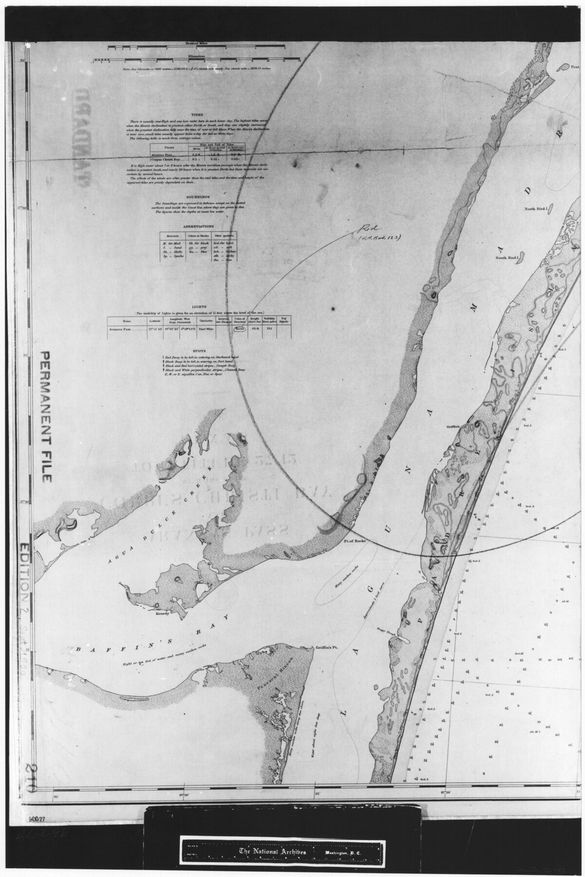
Coast Chart No. 210 Aransas Pass and Corpus Christi Bay with the coast to latitude 27° 12' Texas
RL-2-9b
-
Map/Doc
72792
-
Collection
General Map Collection
-
Object Dates
1887 (Creation Date)
-
People and Organizations
U. S. Coast and Geodetic Survey (Publisher)
-
Counties
Nueces
-
Subjects
Nautical Charts
-
Height x Width
27.3 x 18.2 inches
69.3 x 46.2 cm
-
Comments
B/W photostat copy from National Archives in multiple pieces.
Part of: General Map Collection
Flight Mission No. BRA-16M, Frame 102, Jefferson County

Print $20.00
- Digital $50.00
Flight Mission No. BRA-16M, Frame 102, Jefferson County
1953
Size 18.6 x 22.3 inches
Map/Doc 85714
Flight Mission No. CUG-3P, Frame 141, Kleberg County

Print $20.00
- Digital $50.00
Flight Mission No. CUG-3P, Frame 141, Kleberg County
1956
Size 18.4 x 22.2 inches
Map/Doc 86276
Galveston County Working Sketch 12

Print $20.00
- Digital $50.00
Galveston County Working Sketch 12
1967
Size 14.8 x 22.4 inches
Map/Doc 69349
Terry County Sketch File 2

Print $8.00
- Digital $50.00
Terry County Sketch File 2
Size 8.9 x 11.4 inches
Map/Doc 38012
Gulf Intracoastal Waterway - Texas Erosion at the West End of Bolivar Peninsula Comparative Shorelines

Print $20.00
- Digital $50.00
Gulf Intracoastal Waterway - Texas Erosion at the West End of Bolivar Peninsula Comparative Shorelines
1950
Size 29.0 x 40.3 inches
Map/Doc 61826
Trinity County Sketch File 36

Print $20.00
- Digital $50.00
Trinity County Sketch File 36
Size 43.4 x 18.1 inches
Map/Doc 10408
Presidio County Sketch File 98

Print $44.00
- Digital $50.00
Presidio County Sketch File 98
1955
Size 11.3 x 8.8 inches
Map/Doc 34783
Presidio County

Print $40.00
- Digital $50.00
Presidio County
1875
Size 97.8 x 33.5 inches
Map/Doc 88867
[Gulf Coast portion of] Map of the State of Texas
![72707, [Gulf Coast portion of] Map of the State of Texas, General Map Collection](https://historictexasmaps.com/wmedia_w700/maps/72707.tif.jpg)
Print $20.00
- Digital $50.00
[Gulf Coast portion of] Map of the State of Texas
1865
Size 27.4 x 18.1 inches
Map/Doc 72707
Brazoria County Rolled Sketch 23

Print $20.00
- Digital $50.00
Brazoria County Rolled Sketch 23
1931
Size 39.2 x 37.3 inches
Map/Doc 10691
Hutchinson County Boundary File 4

Print $17.00
- Digital $50.00
Hutchinson County Boundary File 4
Size 14.3 x 8.7 inches
Map/Doc 55305
Flight Mission No. DCL-6C, Frame 72, Kenedy County

Print $20.00
- Digital $50.00
Flight Mission No. DCL-6C, Frame 72, Kenedy County
1943
Size 18.6 x 22.3 inches
Map/Doc 85914
You may also like
Harrison County Rolled Sketch 10

Print $20.00
- Digital $50.00
Harrison County Rolled Sketch 10
1956
Size 33.6 x 26.1 inches
Map/Doc 6153
[Surveying Sketch of Houston and Texas Central R. R. Co., Gunter & Munson, Houston & Great Northern R. R. Co., International & Great Northern R. R. Company, et al]
![75763, [Surveying Sketch of Houston and Texas Central R. R. Co., Gunter & Munson, Houston & Great Northern R. R. Co., International & Great Northern R. R. Company, et al], Maddox Collection](https://historictexasmaps.com/wmedia_w700/maps/75763.tif.jpg)
Print $20.00
- Digital $50.00
[Surveying Sketch of Houston and Texas Central R. R. Co., Gunter & Munson, Houston & Great Northern R. R. Co., International & Great Northern R. R. Company, et al]
Size 23.1 x 28.3 inches
Map/Doc 75763
Aransas County Rolled Sketch 1

Print $40.00
- Digital $50.00
Aransas County Rolled Sketch 1
1930
Size 16.6 x 53.4 inches
Map/Doc 8404
Aransas County Boundary File 7

Print $2.00
- Digital $50.00
Aransas County Boundary File 7
Size 8.8 x 14.2 inches
Map/Doc 50042
Flight Mission No. DQO-12K, Frame 43, Galveston County

Print $20.00
- Digital $50.00
Flight Mission No. DQO-12K, Frame 43, Galveston County
1952
Size 18.6 x 22.4 inches
Map/Doc 85233
Flight Mission No. CGI-3N, Frame 127, Cameron County

Print $20.00
- Digital $50.00
Flight Mission No. CGI-3N, Frame 127, Cameron County
1954
Size 18.8 x 22.4 inches
Map/Doc 84600
Wayside Notes East Bound Along Sunset Route

Wayside Notes East Bound Along Sunset Route
1915
Map/Doc 96718
Texas - the Land of Plenty and Promise where the People Combine the Culture of the East with the Vision of the West and the Energy of the North with the Hospitality of the South

Print $20.00
- Digital $50.00
Texas - the Land of Plenty and Promise where the People Combine the Culture of the East with the Vision of the West and the Energy of the North with the Hospitality of the South
1937
Size 7.2 x 10.5 inches
Map/Doc 96596
Flight Mission No. DCL-7C, Frame 149, Kenedy County

Print $20.00
- Digital $50.00
Flight Mission No. DCL-7C, Frame 149, Kenedy County
1943
Size 18.7 x 22.5 inches
Map/Doc 86106
General Highway Map, Camp County, Morris County, Titus County, Texas

Print $20.00
General Highway Map, Camp County, Morris County, Titus County, Texas
1961
Size 24.7 x 18.1 inches
Map/Doc 79400
Dawson County Boundary File 3 (3)

Print $60.00
- Digital $50.00
Dawson County Boundary File 3 (3)
Size 11.0 x 35.8 inches
Map/Doc 52369
Sketch G Showing the Progress of the Survey in Section VII From 1849 to 1852

Print $20.00
- Digital $50.00
Sketch G Showing the Progress of the Survey in Section VII From 1849 to 1852
1852
Size 13.6 x 25.8 inches
Map/Doc 97219