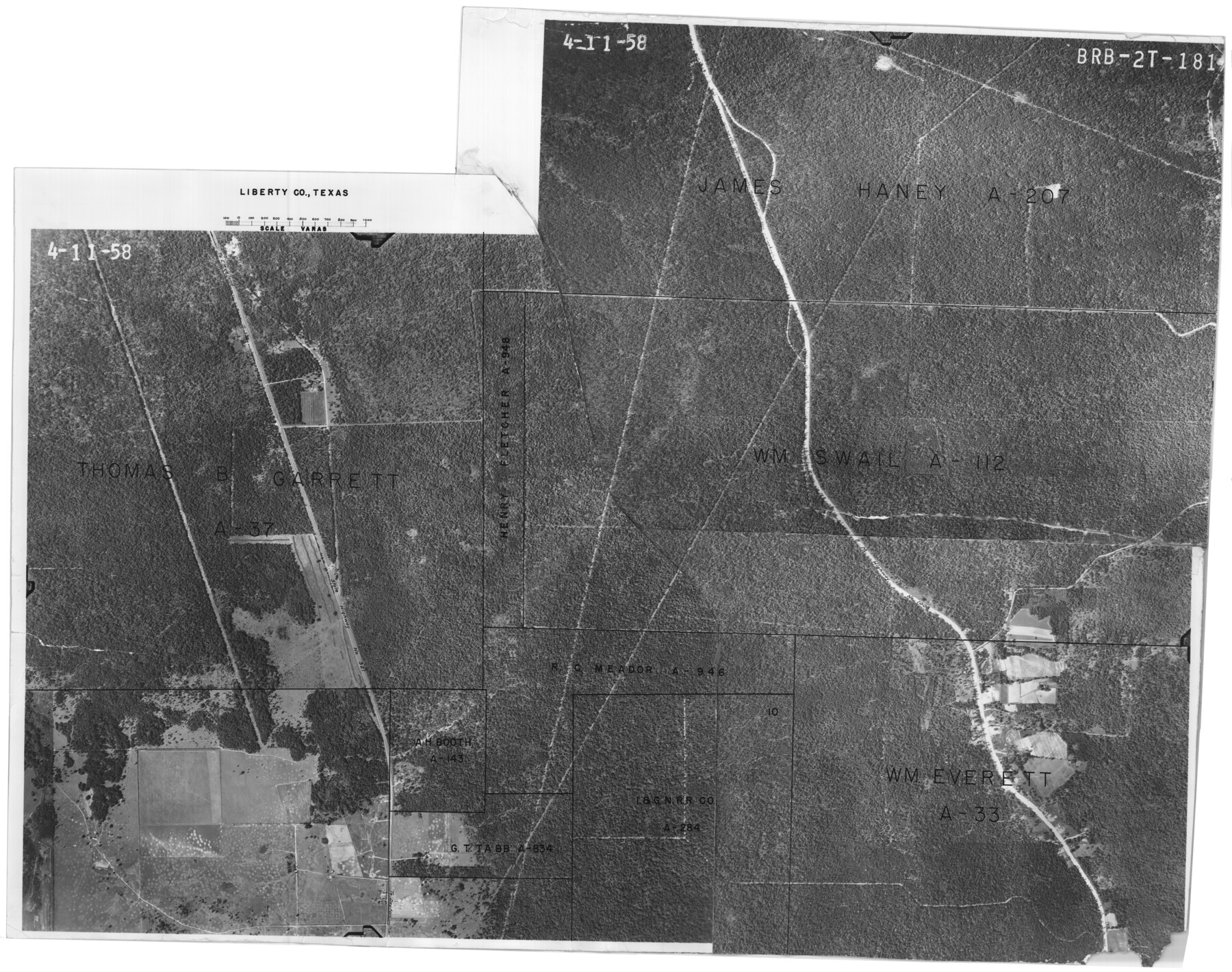
Liberty County Rolled Sketch 2S
[Aerial photo, BRB-2T-181, with original survey overlay in vicinity of R.C. Meador A-946]
-
Map/Doc
10660
-
Collection
General Map Collection
-
Object Dates
1958/4/11 (Creation Date)
1974/10/10 (File Date)
-
Counties
Liberty
-
Subjects
Surveying Rolled Sketch
-
Height x Width
32.0 x 40.6 inches
81.3 x 103.1 cm
-
Medium
photograph
Part of: General Map Collection
Montague County

Print $20.00
- Digital $50.00
Montague County
1924
Size 47.9 x 34.7 inches
Map/Doc 95593
Val Verde County Working Sketch 19

Print $40.00
- Digital $50.00
Val Verde County Working Sketch 19
1928
Size 48.5 x 43.5 inches
Map/Doc 72154
Coleman County Sketch File 24a

Print $6.00
- Digital $50.00
Coleman County Sketch File 24a
1872
Size 10.2 x 15.9 inches
Map/Doc 18708
Harrison County Rolled Sketch 8

Print $33.00
- Digital $50.00
Harrison County Rolled Sketch 8
Size 10.1 x 15.2 inches
Map/Doc 45825
Throckmorton County Working Sketch 3

Print $20.00
- Digital $50.00
Throckmorton County Working Sketch 3
1924
Size 19.8 x 23.8 inches
Map/Doc 62112
Atascosa County Rolled Sketch 20

Print $20.00
- Digital $50.00
Atascosa County Rolled Sketch 20
1956
Size 36.0 x 44.0 inches
Map/Doc 8432
Reeves County Rolled Sketch 24

Print $20.00
- Digital $50.00
Reeves County Rolled Sketch 24
1982
Size 37.2 x 24.9 inches
Map/Doc 7493
El Paso County Working Sketch 7

Print $20.00
- Digital $50.00
El Paso County Working Sketch 7
1928
Size 25.7 x 16.9 inches
Map/Doc 69029
Hood County Working Sketch 30

Print $20.00
- Digital $50.00
Hood County Working Sketch 30
1990
Size 26.6 x 29.9 inches
Map/Doc 66224
Travis County Rolled Sketch 38

Print $20.00
- Digital $50.00
Travis County Rolled Sketch 38
Size 31.9 x 30.3 inches
Map/Doc 8038
Schleicher County Sketch File 41

Print $6.00
- Digital $50.00
Schleicher County Sketch File 41
1963
Size 16.2 x 9.9 inches
Map/Doc 36544

You may also like
Presidio County Rolled Sketch 144

Print $20.00
- Digital $50.00
Presidio County Rolled Sketch 144
2010
Size 36.0 x 24.0 inches
Map/Doc 89603
Val Verde County Sketch File 56

Print $2.00
- Digital $50.00
Val Verde County Sketch File 56
2006
Size 8.5 x 11.0 inches
Map/Doc 89016
Webb County Rolled Sketch 61

Print $20.00
- Digital $50.00
Webb County Rolled Sketch 61
1947
Size 38.6 x 36.5 inches
Map/Doc 10128
Nueces County Rolled Sketch 24

Print $20.00
- Digital $50.00
Nueces County Rolled Sketch 24
Size 19.6 x 24.8 inches
Map/Doc 6873
Brazoria County Working Sketch 22

Print $20.00
- Digital $50.00
Brazoria County Working Sketch 22
1959
Size 27.0 x 25.3 inches
Map/Doc 67507
[Surveys in the Travis District along the Colorado River]
![118, [Surveys in the Travis District along the Colorado River], General Map Collection](https://historictexasmaps.com/wmedia_w700/maps/118.tif.jpg)
Print $2.00
- Digital $50.00
[Surveys in the Travis District along the Colorado River]
1841
Size 8.6 x 15.3 inches
Map/Doc 118
Val Verde County Sketch File 32

Print $20.00
- Digital $50.00
Val Verde County Sketch File 32
Size 45.1 x 20.1 inches
Map/Doc 10420

Flight Mission No. BRA-8M, Frame 122, Jefferson County

Print $20.00
- Digital $50.00
Flight Mission No. BRA-8M, Frame 122, Jefferson County
1953
Size 18.5 x 22.4 inches
Map/Doc 85618
Brewster County Rolled Sketch 97

Print $20.00
- Digital $50.00
Brewster County Rolled Sketch 97
1952
Size 31.6 x 30.7 inches
Map/Doc 5254
Liberty County Sketch File 20

Print $6.00
- Digital $50.00
Liberty County Sketch File 20
Size 7.8 x 9.9 inches
Map/Doc 29925
Dickens County Sketch File N

Print $4.00
- Digital $50.00
Dickens County Sketch File N
1903
Size 8.3 x 13.6 inches
Map/Doc 20942