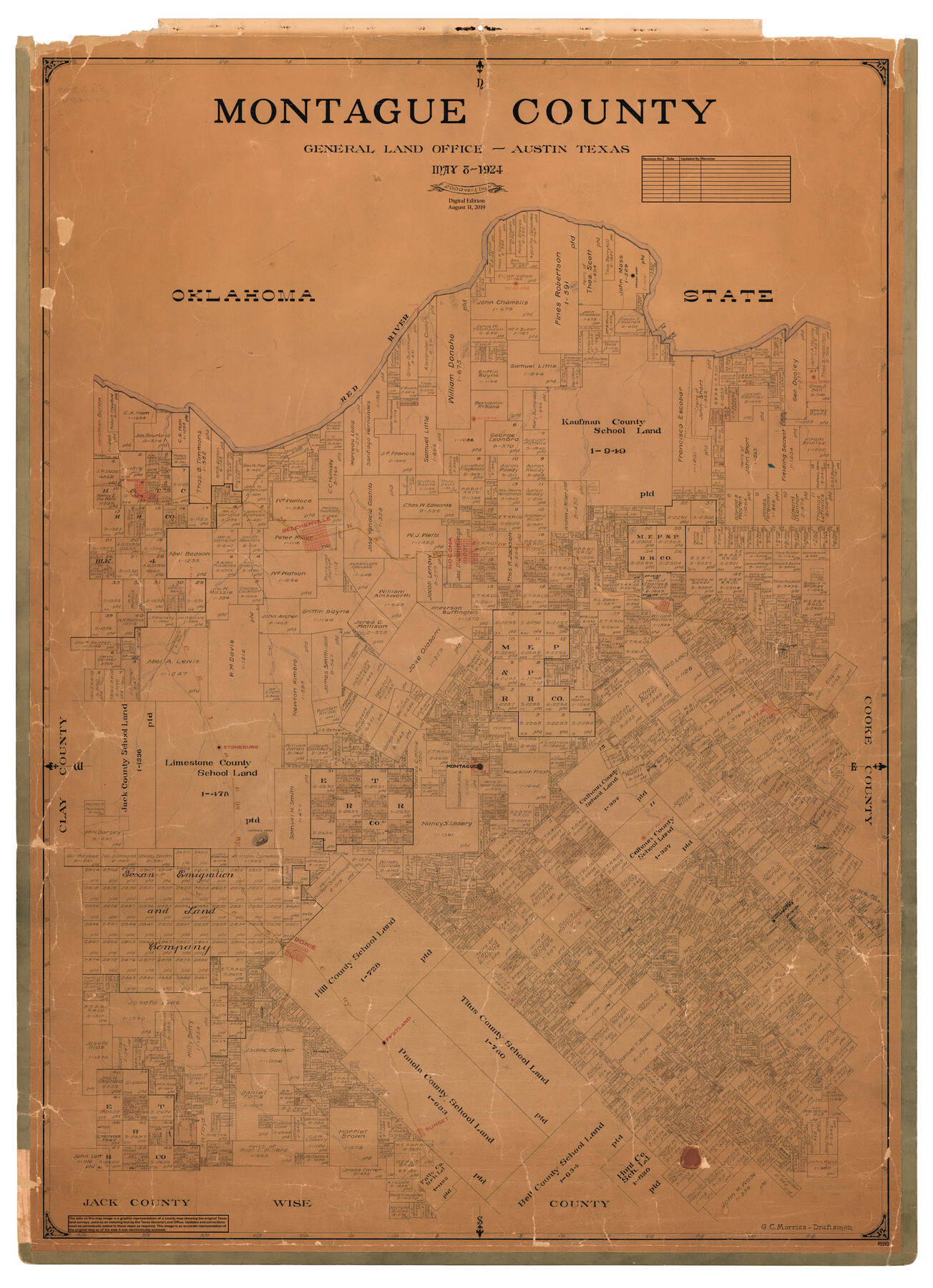
Montague County
General Land Office Official County Map
-
Map/Doc
95593
-
Collection
General Map Collection
-
Object Dates
2019/8/31 (Revision Date)
1924/5/8 (Creation Date)
-
People and Organizations
Cheyenne Betancourt (Draftsman)
G.C. Morriss (Draftsman)
-
Counties
Montague
-
Subjects
County OCM
-
Height x Width
47.9 x 34.7 inches
121.7 x 88.1 cm
-
Medium
digital image
-
Scale
1" = 2000 varas
Part of: General Map Collection
Presidio County Sketch File 58

Print $40.00
- Digital $50.00
Presidio County Sketch File 58
1933
Size 14.7 x 14.4 inches
Map/Doc 34635
Texas Official Highway Travel Map

Digital $50.00
Texas Official Highway Travel Map
Size 27.1 x 36.2 inches
Map/Doc 94311
Hardin County Sketch File 27

Print $4.00
- Digital $50.00
Hardin County Sketch File 27
Size 13.0 x 8.1 inches
Map/Doc 25151
Map of Bexar County

Print $40.00
- Digital $50.00
Map of Bexar County
1845
Size 48.8 x 43.0 inches
Map/Doc 87237
Wilbarger County Sketch File 2

Print $4.00
- Digital $50.00
Wilbarger County Sketch File 2
1862
Size 8.9 x 7.9 inches
Map/Doc 40164
Flight Mission No. CUG-3P, Frame 163, Kleberg County

Print $20.00
- Digital $50.00
Flight Mission No. CUG-3P, Frame 163, Kleberg County
1956
Size 18.6 x 22.2 inches
Map/Doc 86283
Harbor Pass and Bar at Brazos Santiago, Texas

Print $20.00
- Digital $50.00
Harbor Pass and Bar at Brazos Santiago, Texas
1871
Size 18.2 x 26.3 inches
Map/Doc 72985
[Surveys in Austin's Colony along the west bank of the San Jacinto River]
![79, [Surveys in Austin's Colony along the west bank of the San Jacinto River], General Map Collection](https://historictexasmaps.com/wmedia_w700/maps/79-1.tif.jpg)
Print $20.00
- Digital $50.00
[Surveys in Austin's Colony along the west bank of the San Jacinto River]
1831
Size 25.0 x 22.0 inches
Map/Doc 79
Calhoun County Rolled Sketch 18

Print $20.00
- Digital $50.00
Calhoun County Rolled Sketch 18
1952
Size 12.2 x 11.9 inches
Map/Doc 5371
Map of the Fort Worth & Denver City Railway, Wichita County, Texas

Print $40.00
- Digital $50.00
Map of the Fort Worth & Denver City Railway, Wichita County, Texas
1885
Size 23.7 x 66.5 inches
Map/Doc 64455
Leon County Working Sketch 16

Print $20.00
- Digital $50.00
Leon County Working Sketch 16
1958
Size 26.9 x 30.7 inches
Map/Doc 70415
Harris County Rolled Sketch 75

Print $20.00
- Digital $50.00
Harris County Rolled Sketch 75
1951
Size 33.8 x 34.9 inches
Map/Doc 76168
You may also like
Jackson County Sketch File 9

Print $24.00
- Digital $50.00
Jackson County Sketch File 9
1898
Size 11.3 x 8.8 inches
Map/Doc 27651
Map of the city of San Antonio, Bexar County, Texas including suburbs both north and south

Print $20.00
Map of the city of San Antonio, Bexar County, Texas including suburbs both north and south
1924
Size 37.0 x 24.5 inches
Map/Doc 93556

Cherokee County Boundary File 3

Print $34.00
- Digital $50.00
Cherokee County Boundary File 3
Size 11.2 x 8.8 inches
Map/Doc 51285
La Florida / Peruviae Avriferæ Regionis Typus / Guastecan

Print $20.00
- Digital $50.00
La Florida / Peruviae Avriferæ Regionis Typus / Guastecan
1584
Size 16.8 x 20.9 inches
Map/Doc 94100
Map of Denton County

Print $20.00
- Digital $50.00
Map of Denton County
1897
Size 45.0 x 41.2 inches
Map/Doc 66802
[Surveys in the Bexar District along the Leona River]
![135, [Surveys in the Bexar District along the Leona River], General Map Collection](https://historictexasmaps.com/wmedia_w700/maps/135.tif.jpg)
Print $20.00
- Digital $50.00
[Surveys in the Bexar District along the Leona River]
1841
Size 19.9 x 10.9 inches
Map/Doc 135
Louisiana and Texas Intracoastal Waterway - Matagorda Bay to San Antonio Bay Dredging - Sheet 1

Print $20.00
- Digital $50.00
Louisiana and Texas Intracoastal Waterway - Matagorda Bay to San Antonio Bay Dredging - Sheet 1
1942
Size 31.2 x 41.2 inches
Map/Doc 61823
Howard County Working Sketch 10

Print $20.00
- Digital $50.00
Howard County Working Sketch 10
1962
Size 24.4 x 26.1 inches
Map/Doc 66278
Shelby County Working Sketch 29b

Print $20.00
- Digital $50.00
Shelby County Working Sketch 29b
2000
Size 25.2 x 37.8 inches
Map/Doc 63884
[Galveston, Harrisburg & San Antonio Railroad from Cuero to Stockdale]
![64191, [Galveston, Harrisburg & San Antonio Railroad from Cuero to Stockdale], General Map Collection](https://historictexasmaps.com/wmedia_w700/maps/64191.tif.jpg)
Print $20.00
- Digital $50.00
[Galveston, Harrisburg & San Antonio Railroad from Cuero to Stockdale]
1907
Size 14.2 x 34.2 inches
Map/Doc 64191
