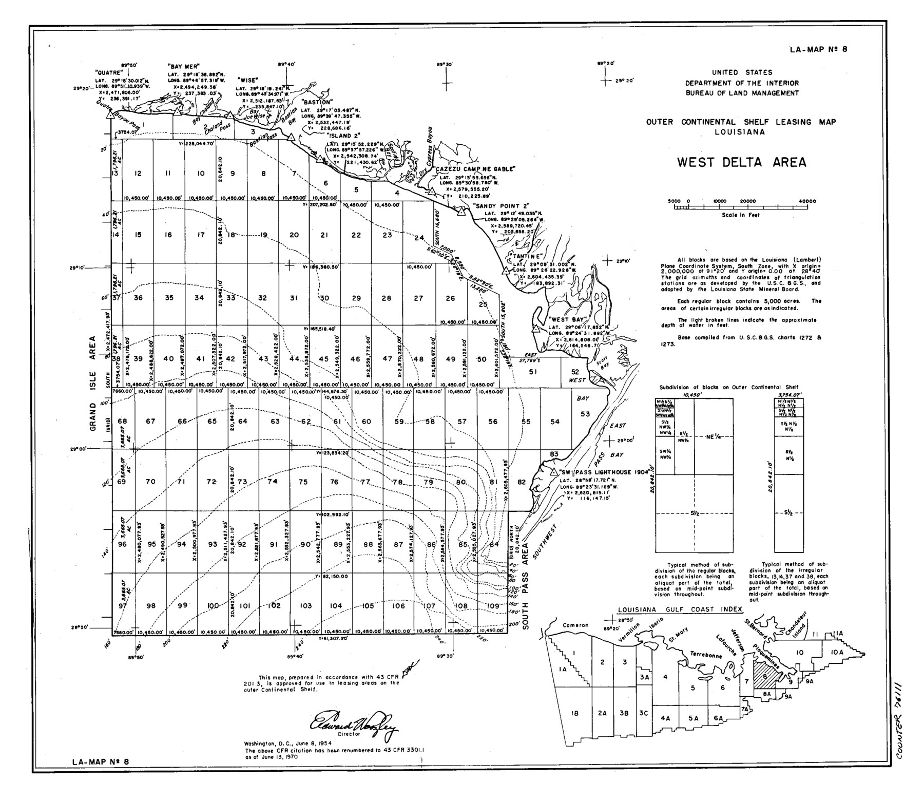
Outer Continental Shelf Leasing Maps (Louisiana Offshore Operations)
D-7-3; D-7-4
-
Map/Doc
76111
-
Collection
General Map Collection
-
Object Dates
1954/6/8 (Creation Date)
-
Subjects
Energy Offshore Submerged Area
-
Height x Width
13.0 x 15.0 inches
33.0 x 38.1 cm
Part of: General Map Collection
Map of section no. 5 of a survey of Padre Island made for the Office of the Attorney General of the State of Texas

Print $40.00
- Digital $50.00
Map of section no. 5 of a survey of Padre Island made for the Office of the Attorney General of the State of Texas
1941
Size 49.8 x 40.0 inches
Map/Doc 2261
Oldham County

Print $40.00
- Digital $50.00
Oldham County
1925
Size 40.5 x 52.1 inches
Map/Doc 73254

Gonzales County Sketch File 10

Print $4.00
- Digital $50.00
Gonzales County Sketch File 10
1873
Size 8.4 x 5.2 inches
Map/Doc 24390
Flight Mission No. DIX-8P, Frame 90, Aransas County

Print $20.00
- Digital $50.00
Flight Mission No. DIX-8P, Frame 90, Aransas County
1956
Size 18.6 x 22.4 inches
Map/Doc 83915
Pecos County Working Sketch 9

Print $20.00
- Digital $50.00
Pecos County Working Sketch 9
1907
Size 32.4 x 26.7 inches
Map/Doc 71479
Hale County Working Sketch 5

Print $20.00
- Digital $50.00
Hale County Working Sketch 5
1980
Size 15.0 x 11.1 inches
Map/Doc 63325
Yoakum County Rolled Sketch 2

Print $20.00
- Digital $50.00
Yoakum County Rolled Sketch 2
1943
Size 18.6 x 33.4 inches
Map/Doc 8288
Kerr County Working Sketch Graphic Index

Print $40.00
- Digital $50.00
Kerr County Working Sketch Graphic Index
1923
Size 40.4 x 55.9 inches
Map/Doc 76605
Hopkins County Sketch File 16

Print $4.00
- Digital $50.00
Hopkins County Sketch File 16
1870
Size 8.1 x 10.1 inches
Map/Doc 26713
Nueces County Rolled Sketch 136

Print $40.00
- Digital $50.00
Nueces County Rolled Sketch 136
2006
Size 37.5 x 50.0 inches
Map/Doc 83556
Polk County Working Sketch 3

Print $40.00
- Digital $50.00
Polk County Working Sketch 3
1911
Size 25.4 x 56.0 inches
Map/Doc 71618
You may also like

Terry County Sketch File 11

Print $20.00
- Digital $50.00
Terry County Sketch File 11
Size 10.9 x 43.2 inches
Map/Doc 10395
Comanche County Working Sketch 22

Print $20.00
- Digital $50.00
Comanche County Working Sketch 22
1974
Size 23.7 x 23.1 inches
Map/Doc 68156
Jones County Rolled Sketch 2

Print $40.00
- Digital $50.00
Jones County Rolled Sketch 2
2009
Size 48.0 x 34.0 inches
Map/Doc 93320
Hutchinson County Rolled Sketch 43

Print $40.00
- Digital $50.00
Hutchinson County Rolled Sketch 43
1992
Size 38.0 x 49.4 inches
Map/Doc 6311
Railroad Track Map, H&TCRRCo., Falls County, Texas

Print $4.00
- Digital $50.00
Railroad Track Map, H&TCRRCo., Falls County, Texas
1918
Size 11.8 x 18.6 inches
Map/Doc 62836
Hemphill County Sketch File 5

Print $8.00
- Digital $50.00
Hemphill County Sketch File 5
1903
Size 11.2 x 8.8 inches
Map/Doc 26295
[Blocks 5-T, M-23, and vicinity]
![91230, [Blocks 5-T, M-23, and vicinity], Twichell Survey Records](https://historictexasmaps.com/wmedia_w700/maps/91230-1.tif.jpg)
Print $20.00
- Digital $50.00
[Blocks 5-T, M-23, and vicinity]
1890
Size 39.0 x 22.7 inches
Map/Doc 91230
Webb County Rolled Sketch 68

Print $43.00
- Digital $50.00
Webb County Rolled Sketch 68
1910
Size 9.6 x 15.1 inches
Map/Doc 49485
Crosby County Sketch File 26

Print $28.00
- Digital $50.00
Crosby County Sketch File 26
1888
Size 14.1 x 8.6 inches
Map/Doc 20098
Donley County Sketch File 12

Print $2.00
- Digital $50.00
Donley County Sketch File 12
Size 12.9 x 8.2 inches
Map/Doc 21248
Current Miscellaneous File 48

Print $32.00
- Digital $50.00
Current Miscellaneous File 48
Size 11.2 x 8.7 inches
Map/Doc 73996