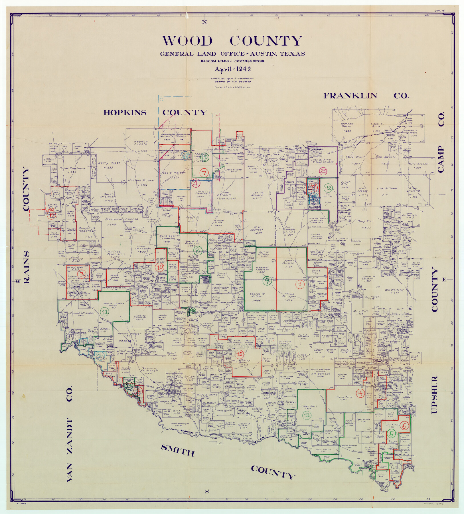
Wood County Working Sketch Graphic Index
-
Map/Doc
76746
-
Collection
General Map Collection
-
Object Dates
4/1942 (Creation Date)
-
People and Organizations
W. S. Brewington (Compiler)
Wm. Proctor (Draftsman)
-
Counties
Wood
-
Subjects
County Surveying Working Sketch
-
Height x Width
40.6 x 36.4 inches
103.1 x 92.5 cm
-
Scale
1" = 2000 varas
Part of: General Map Collection
Borden County Sketch File 12

Print $24.00
- Digital $50.00
Borden County Sketch File 12
Size 10.8 x 9.1 inches
Map/Doc 14732
Map of Oceanica engraved to illustrate Mitchell's new intermediate geography

Print $20.00
- Digital $50.00
Map of Oceanica engraved to illustrate Mitchell's new intermediate geography
1885
Size 9.0 x 12.2 inches
Map/Doc 93531
Sutton County Sketch File 2

Print $4.00
- Digital $50.00
Sutton County Sketch File 2
1898
Size 6.1 x 9.7 inches
Map/Doc 37351
Flight Mission No. BRA-3M, Frame 125, Jefferson County

Print $20.00
- Digital $50.00
Flight Mission No. BRA-3M, Frame 125, Jefferson County
1953
Size 18.6 x 21.5 inches
Map/Doc 85399

Rusk County Sketch File 36

Print $20.00
Rusk County Sketch File 36
1950
Size 23.8 x 18.0 inches
Map/Doc 12274
Flight Mission No. CLL-3N, Frame 15, Willacy County

Print $20.00
- Digital $50.00
Flight Mission No. CLL-3N, Frame 15, Willacy County
1950
Size 18.4 x 22.0 inches
Map/Doc 87081
Flight Mission No. DCL-7C, Frame 4, Kenedy County

Print $20.00
- Digital $50.00
Flight Mission No. DCL-7C, Frame 4, Kenedy County
1943
Size 18.6 x 22.3 inches
Map/Doc 85996
Hood County Sketch File 22

Print $6.00
- Digital $50.00
Hood County Sketch File 22
Size 15.7 x 9.3 inches
Map/Doc 26615
Bee County Sketch File 16

Print $4.00
- Digital $50.00
Bee County Sketch File 16
1878
Size 8.6 x 7.7 inches
Map/Doc 14299
Val Verde County Sketch File A1

Print $6.00
- Digital $50.00
Val Verde County Sketch File A1
1895
Size 14.4 x 9.2 inches
Map/Doc 39038
Wilbarger County Boundary File 1

Print $52.00
- Digital $50.00
Wilbarger County Boundary File 1
Size 8.9 x 5.6 inches
Map/Doc 59916
You may also like
Wilson County Working Sketch 14

Print $20.00
- Digital $50.00
Wilson County Working Sketch 14
1987
Size 31.9 x 36.2 inches
Map/Doc 72594
Newton County Working Sketch 37

Print $20.00
- Digital $50.00
Newton County Working Sketch 37
1960
Size 31.7 x 22.7 inches
Map/Doc 71283
Map of Live Oak County, Texas

Print $20.00
- Digital $50.00
Map of Live Oak County, Texas
1911
Size 28.0 x 20.4 inches
Map/Doc 567
[Surveys in Austin's Colony along the Colorado River]
![198, [Surveys in Austin's Colony along the Colorado River], General Map Collection](https://historictexasmaps.com/wmedia_w700/maps/198.tif.jpg)
Print $20.00
- Digital $50.00
[Surveys in Austin's Colony along the Colorado River]
1830
Size 38.9 x 23.2 inches
Map/Doc 198
Jim Wells County Working Sketch 7

Print $20.00
- Digital $50.00
Jim Wells County Working Sketch 7
1944
Size 26.2 x 29.3 inches
Map/Doc 66605
Moore County Sketch to Accompany Corrected Field Notes of Sections in Block G. & M. 3]
![91415, Moore County Sketch to Accompany Corrected Field Notes of Sections in Block G. & M. 3], Twichell Survey Records](https://historictexasmaps.com/wmedia_w700/maps/91415-1.tif.jpg)
Print $20.00
- Digital $50.00
Moore County Sketch to Accompany Corrected Field Notes of Sections in Block G. & M. 3]
1913
Size 17.9 x 15.0 inches
Map/Doc 91415
Val Verde County Working Sketch 77

Print $20.00
- Digital $50.00
Val Verde County Working Sketch 77
1972
Size 45.9 x 38.5 inches
Map/Doc 72212
Childress County

Print $20.00
- Digital $50.00
Childress County
1884
Size 20.6 x 17.4 inches
Map/Doc 3395
Motley County Boundary File 1

Print $46.00
- Digital $50.00
Motley County Boundary File 1
Size 9.0 x 4.1 inches
Map/Doc 57488
[Surveys in the Jefferson District]
![3177, [Surveys in the Jefferson District], General Map Collection](https://historictexasmaps.com/wmedia_w700/maps/3177.tif.jpg)
Print $2.00
- Digital $50.00
[Surveys in the Jefferson District]
1841
Size 9.8 x 8.0 inches
Map/Doc 3177
Marion County, Texas

Print $20.00
- Digital $50.00
Marion County, Texas
1879
Size 15.0 x 20.7 inches
Map/Doc 651
Map of Hopkins County

Print $20.00
- Digital $50.00
Map of Hopkins County
1863
Size 22.6 x 24.1 inches
Map/Doc 3679