
Flight Mission No. DCL-7C, Frame 4, Kenedy County
DCL-7C-4
-
Map/Doc
85996
-
Collection
General Map Collection
-
Object Dates
1943/2/13 (Creation Date)
-
People and Organizations
U. S. Department of Agriculture (Publisher)
-
Counties
Kenedy
-
Subjects
Aerial Photograph
-
Height x Width
18.6 x 22.3 inches
47.2 x 56.6 cm
-
Comments
Flown by Aerial Surveys of Pittsburgh, Inc. of Pittsburgh, Pennsylvania.
Part of: General Map Collection
Schleicher County Rolled Sketch 3

Print $20.00
- Digital $50.00
Schleicher County Rolled Sketch 3
1890
Size 41.5 x 31.2 inches
Map/Doc 8362
Upton County Rolled Sketch 35

Print $20.00
- Digital $50.00
Upton County Rolled Sketch 35
1951
Size 37.3 x 19.2 inches
Map/Doc 8077
[Sketch showing the Rio Grande with towns and features annotated]
![72895, [Sketch showing the Rio Grande with towns and features annotated], General Map Collection](https://historictexasmaps.com/wmedia_w700/maps/72895.tif.jpg)
Print $20.00
- Digital $50.00
[Sketch showing the Rio Grande with towns and features annotated]
1854
Size 24.4 x 18.3 inches
Map/Doc 72895
Hood County Working Sketch Graphic Index

Print $20.00
- Digital $50.00
Hood County Working Sketch Graphic Index
1941
Size 35.9 x 31.8 inches
Map/Doc 76580
Leon County Rolled Sketch 35

Print $20.00
- Digital $50.00
Leon County Rolled Sketch 35
2018
Size 30.7 x 21.3 inches
Map/Doc 95288
Coleman County Sketch File 24

Print $6.00
- Digital $50.00
Coleman County Sketch File 24
1872
Size 8.7 x 7.8 inches
Map/Doc 18705
Aransas Pass to Baffin Bay

Print $20.00
- Digital $50.00
Aransas Pass to Baffin Bay
1971
Size 42.3 x 35.2 inches
Map/Doc 73417
Lynn County Rolled Sketch H

Print $20.00
- Digital $50.00
Lynn County Rolled Sketch H
1902
Size 43.6 x 38.4 inches
Map/Doc 9472
Flight Mission No. DIX-6P, Frame 192, Aransas County

Print $20.00
- Digital $50.00
Flight Mission No. DIX-6P, Frame 192, Aransas County
1956
Size 19.0 x 22.8 inches
Map/Doc 83854
Trinity County Sketch File 1

Print $4.00
- Digital $50.00
Trinity County Sketch File 1
1855
Size 8.3 x 8.2 inches
Map/Doc 38488
Blanco County Sketch File 23

Print $16.00
- Digital $50.00
Blanco County Sketch File 23
1887
Size 8.7 x 14.1 inches
Map/Doc 14606
Wichita County Working Sketch Graphic Index

Print $20.00
- Digital $50.00
Wichita County Working Sketch Graphic Index
1971
Size 36.7 x 38.5 inches
Map/Doc 76739
You may also like
Anderson County Sketch File 8

Print $4.00
- Digital $50.00
Anderson County Sketch File 8
1848
Size 5.8 x 8.0 inches
Map/Doc 12759
The Dust Bowl: Severe Drought During the Depression

The Dust Bowl: Severe Drought During the Depression
2022
Size 8.5 x 11.0 inches
Map/Doc 97095

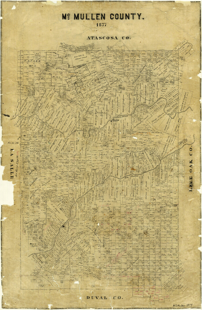
McMullen County
Print $20.00
- Digital $50.00
McMullen County
1877
Size 26.1 x 17.2 inches
Map/Doc 3867
Edwards County Working Sketch 97

Print $20.00
- Digital $50.00
Edwards County Working Sketch 97
1969
Size 25.5 x 27.6 inches
Map/Doc 68973
El Paso County Rolled Sketch 46

Print $20.00
- Digital $50.00
El Paso County Rolled Sketch 46
1937
Size 38.6 x 30.3 inches
Map/Doc 5832
Glasscock County Working Sketch 4

Print $20.00
- Digital $50.00
Glasscock County Working Sketch 4
Size 15.7 x 25.9 inches
Map/Doc 63177
Eastern Heights Addition to City of Lubbock, Texas a Subdivision of SW/4 of SW/4, Section 5, Block O, E. Hayes Sieber, Owner

Print $20.00
- Digital $50.00
Eastern Heights Addition to City of Lubbock, Texas a Subdivision of SW/4 of SW/4, Section 5, Block O, E. Hayes Sieber, Owner
1952
Size 18.0 x 23.1 inches
Map/Doc 92783
Map of Asia engraved to illustrate Mitchell's new intermediate geography (Inset: Map of Palestine or the Holy Land)

Print $20.00
- Digital $50.00
Map of Asia engraved to illustrate Mitchell's new intermediate geography (Inset: Map of Palestine or the Holy Land)
1885
Size 9.0 x 12.2 inches
Map/Doc 93529
Brazos River, Brazos River Sheet 1

Print $4.00
- Digital $50.00
Brazos River, Brazos River Sheet 1
1926
Size 21.5 x 25.4 inches
Map/Doc 65293
General Highway Map. Detail of Cities and Towns in Tarrant County, Texas. City Map, Fort Worth and vicinity, Tarrant County, Texas

Print $20.00
General Highway Map. Detail of Cities and Towns in Tarrant County, Texas. City Map, Fort Worth and vicinity, Tarrant County, Texas
1961
Size 18.2 x 24.8 inches
Map/Doc 79669
Travis County Boundary File 28

Print $8.00
- Digital $50.00
Travis County Boundary File 28
Size 14.7 x 9.0 inches
Map/Doc 59464