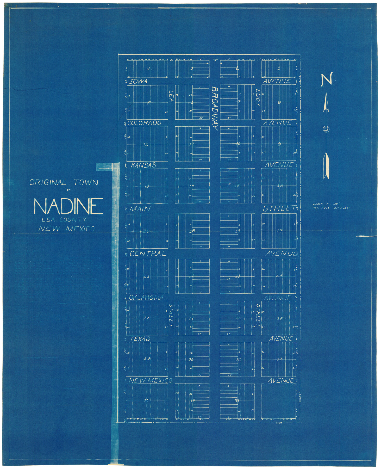
Original Town of Nadine, Lea County, New Mexico
-
Map/Doc
92434
-
Collection
Twichell Survey Records
-
Object Dates
1928 (Creation Date)
-
Counties
Lea [New Mexico]
-
Height x Width
27.6 x 34.0 inches
70.1 x 86.4 cm
Part of: Twichell Survey Records
[Famous Heights Addition to Amarillo, Texas]
![91786, [Famous Heights Addition to Amarillo, Texas], Twichell Survey Records](https://historictexasmaps.com/wmedia_w700/maps/91786-1.tif.jpg)
Print $20.00
- Digital $50.00
[Famous Heights Addition to Amarillo, Texas]
Size 20.3 x 15.6 inches
Map/Doc 91786
[North 3/4 of County]
![90840, [North 3/4 of County], Twichell Survey Records](https://historictexasmaps.com/wmedia_w700/maps/90840-2.tif.jpg)
Print $20.00
- Digital $50.00
[North 3/4 of County]
1887
Size 26.0 x 15.4 inches
Map/Doc 90840
[H. & G. N. Block 1]
![90945, [H. & G. N. Block 1], Twichell Survey Records](https://historictexasmaps.com/wmedia_w700/maps/90945-1.tif.jpg)
Print $20.00
- Digital $50.00
[H. & G. N. Block 1]
1873
Size 17.4 x 14.1 inches
Map/Doc 90945
Plat of South Side Addition on Section 37 Block 17, Wheeler County, Texas

Print $20.00
- Digital $50.00
Plat of South Side Addition on Section 37 Block 17, Wheeler County, Texas
Size 12.0 x 16.9 inches
Map/Doc 92103
[Blocks A-10, A-11, and A-12]
![92669, [Blocks A-10, A-11, and A-12], Twichell Survey Records](https://historictexasmaps.com/wmedia_w700/maps/92669-1.tif.jpg)
Print $20.00
- Digital $50.00
[Blocks A-10, A-11, and A-12]
Size 19.7 x 20.0 inches
Map/Doc 92669
Terry County Memorial Cemetery

Print $20.00
- Digital $50.00
Terry County Memorial Cemetery
Size 35.3 x 14.4 inches
Map/Doc 92931
Map of the Survey of the 100th Meridian of Longitude west of Greenwich beginning at Red River and extending to the parallel 36 1/2 degrees north latitude

Print $40.00
- Digital $50.00
Map of the Survey of the 100th Meridian of Longitude west of Greenwich beginning at Red River and extending to the parallel 36 1/2 degrees north latitude
Size 11.4 x 111.7 inches
Map/Doc 93191
Map Showing Block HG and Connecting Surveys

Print $2.00
- Digital $50.00
Map Showing Block HG and Connecting Surveys
1907
Size 9.2 x 13.7 inches
Map/Doc 90681

Map Showing Section Lines and Corporation Lines of the City of Lubbock

Print $20.00
- Digital $50.00
Map Showing Section Lines and Corporation Lines of the City of Lubbock
1921
Size 27.5 x 25.2 inches
Map/Doc 92749
[Strickland Survey Sketch Showing Abercrombie Corner, Exhibit C]
![91370, [Strickland Survey Sketch Showing Abercrombie Corner, Exhibit C], Twichell Survey Records](https://historictexasmaps.com/wmedia_w700/maps/91370-1.tif.jpg)
Print $20.00
- Digital $50.00
[Strickland Survey Sketch Showing Abercrombie Corner, Exhibit C]
Size 25.3 x 19.1 inches
Map/Doc 91370
General Highway Map, Lubbock County

Print $20.00
- Digital $50.00
General Highway Map, Lubbock County
1947
Size 25.1 x 18.9 inches
Map/Doc 92718
You may also like
Chart showing the positions of the lights in the Eighth L. H. District extending from the Perdido River, Florida to the Rio Grande, Texas

Print $20.00
- Digital $50.00
Chart showing the positions of the lights in the Eighth L. H. District extending from the Perdido River, Florida to the Rio Grande, Texas
1876
Size 25.0 x 18.3 inches
Map/Doc 72681
San Saba County Boundary File 77a

Print $51.00
- Digital $50.00
San Saba County Boundary File 77a
Size 17.3 x 10.8 inches
Map/Doc 58591
Louisiana and Texas Intracoastal Waterway - Matagorda Bay to San Antonio Bay Dredging - Sheet 1

Print $20.00
- Digital $50.00
Louisiana and Texas Intracoastal Waterway - Matagorda Bay to San Antonio Bay Dredging - Sheet 1
1942
Size 31.2 x 41.2 inches
Map/Doc 61823
Blanco County Sketch File 24

Print $4.00
- Digital $50.00
Blanco County Sketch File 24
Size 8.9 x 14.4 inches
Map/Doc 14614
Dimmit County Sketch File 22

Print $47.00
- Digital $50.00
Dimmit County Sketch File 22
1906
Size 9.3 x 8.6 inches
Map/Doc 21129

Map of Eastham State Farm, Houston County, Texas

Print $20.00
- Digital $50.00
Map of Eastham State Farm, Houston County, Texas
Size 35.7 x 32.5 inches
Map/Doc 62987
Flight Mission No. CGI-3N, Frame 138, Cameron County

Print $20.00
- Digital $50.00
Flight Mission No. CGI-3N, Frame 138, Cameron County
1954
Size 18.7 x 22.2 inches
Map/Doc 84611
Live Oak County Rolled Sketch 9

Print $20.00
- Digital $50.00
Live Oak County Rolled Sketch 9
1982
Size 25.6 x 23.3 inches
Map/Doc 6636
Americæ Nova Tabula

Print $20.00
- Digital $50.00
Americæ Nova Tabula
1633
Size 15.3 x 18.7 inches
Map/Doc 95827
Crosby County Working Sketch Graphic Index

Print $20.00
- Digital $50.00
Crosby County Working Sketch Graphic Index
1927
Size 41.8 x 37.4 inches
Map/Doc 76513
[Sketch for Mineral Application 24072, San Jacinto River]
![65585, [Sketch for Mineral Application 24072, San Jacinto River], General Map Collection](https://historictexasmaps.com/wmedia_w700/maps/65585.tif.jpg)
Print $20.00
- Digital $50.00
[Sketch for Mineral Application 24072, San Jacinto River]
1929
Size 21.7 x 11.1 inches
Map/Doc 65585