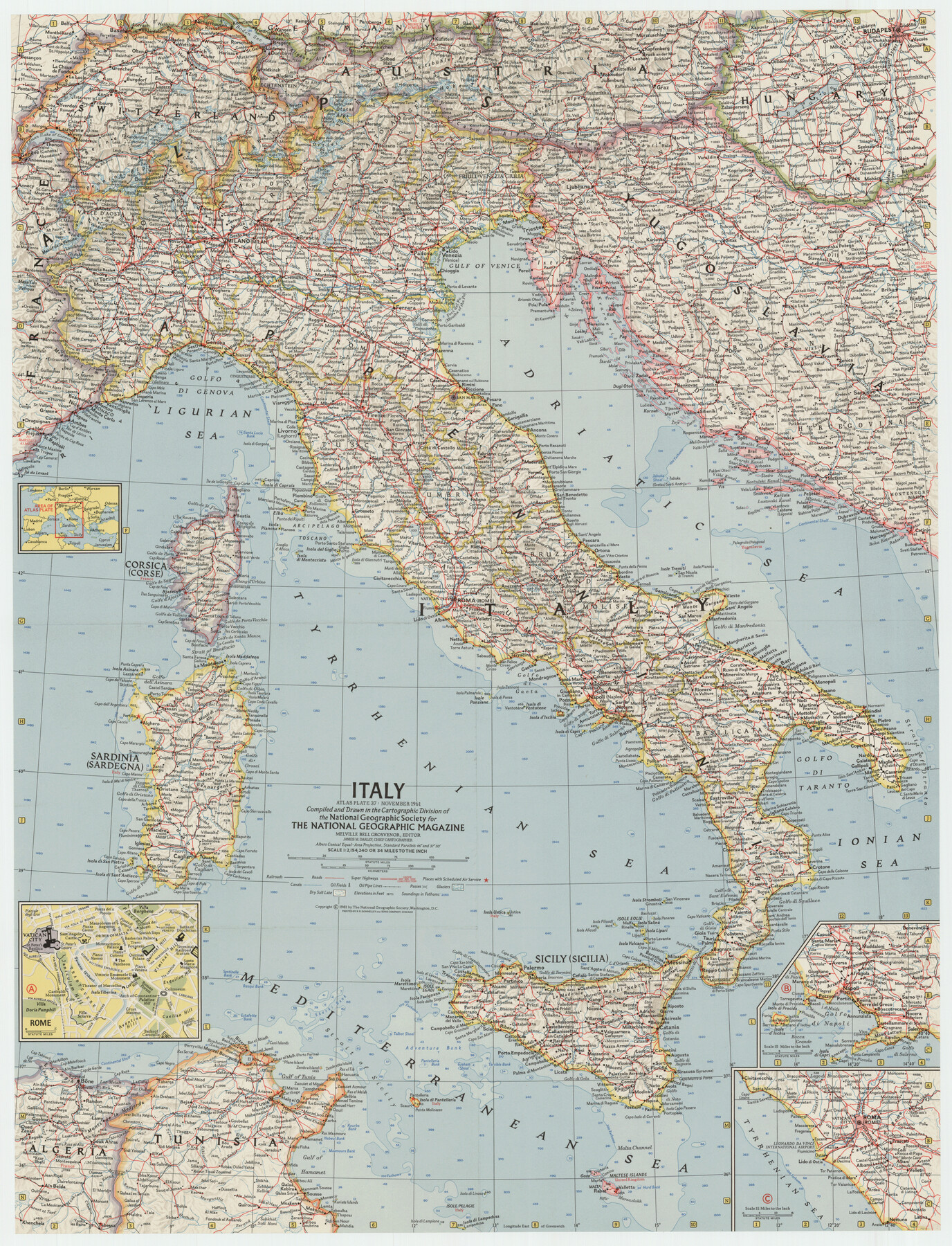
Italy
-
Map/Doc
92365
-
Collection
Twichell Survey Records
-
Object Dates
11/1961 (Creation Date)
-
People and Organizations
National Geographic Society (Compiler)
-
Subjects
Europe
-
Height x Width
19.9 x 25.7 inches
50.6 x 65.3 cm
-
Comments
For research only. Not available for duplication from the GLO.
Part of: Twichell Survey Records
General Highway Map Bailey County, Texas

Print $20.00
- Digital $50.00
General Highway Map Bailey County, Texas
1948
Size 18.7 x 25.8 inches
Map/Doc 92533
Sketch in Crockett County [showing University Land Blocks 42 and 45 and Block A-B]
![90313, Sketch in Crockett County [showing University Land Blocks 42 and 45 and Block A-B], Twichell Survey Records](https://historictexasmaps.com/wmedia_w700/maps/90313-1.tif.jpg)
Print $20.00
- Digital $50.00
Sketch in Crockett County [showing University Land Blocks 42 and 45 and Block A-B]
1913
Size 24.6 x 11.9 inches
Map/Doc 90313
Robertson & Scott V Ranch situated in Crosby County, Texas

Print $40.00
- Digital $50.00
Robertson & Scott V Ranch situated in Crosby County, Texas
Size 41.2 x 48.8 inches
Map/Doc 89758
Ellwood Farms Situated in Hockley, Lamb, and Hale Counties, Texas

Print $20.00
- Digital $50.00
Ellwood Farms Situated in Hockley, Lamb, and Hale Counties, Texas
Size 21.5 x 32.7 inches
Map/Doc 92227

Working Sketch in Pecos Co. [now Val Verde and Terrell Counties] / [Connecting Lines]
![91865, Working Sketch in Pecos Co. [now Val Verde and Terrell Counties] / [Connecting Lines], Twichell Survey Records](https://historictexasmaps.com/wmedia_w700/maps/91865-1.tif.jpg)
Print $20.00
- Digital $50.00
Working Sketch in Pecos Co. [now Val Verde and Terrell Counties] / [Connecting Lines]
Size 18.6 x 24.3 inches
Map/Doc 91865
[North Line of Kent County/South Line of Dickens County]
![90937, [North Line of Kent County/South Line of Dickens County], Twichell Survey Records](https://historictexasmaps.com/wmedia_w700/maps/90937-1.tif.jpg)
Print $20.00
- Digital $50.00
[North Line of Kent County/South Line of Dickens County]
1892
Size 8.4 x 38.1 inches
Map/Doc 90937
Working Sketch in Gray, Donley, and Carson Counties, Texas

Print $20.00
- Digital $50.00
Working Sketch in Gray, Donley, and Carson Counties, Texas
1909
Size 22.7 x 27.0 inches
Map/Doc 90779
Map Showing Soash Lands in Castro, Lamb, and Hale Counties, Texas

Print $20.00
- Digital $50.00
Map Showing Soash Lands in Castro, Lamb, and Hale Counties, Texas
1907
Size 13.9 x 17.6 inches
Map/Doc 91000
Ochiltree County

Print $20.00
- Digital $50.00
Ochiltree County
Size 14.3 x 16.5 inches
Map/Doc 91491
[Pencil sketch of Wm. Rivers survey]
![91968, [Pencil sketch of Wm. Rivers survey], Twichell Survey Records](https://historictexasmaps.com/wmedia_w700/maps/91968-1.tif.jpg)
Print $3.00
- Digital $50.00
[Pencil sketch of Wm. Rivers survey]
Size 10.1 x 16.5 inches
Map/Doc 91968
Whitharral Located on West Half of Labor 11, Capitol League 716 Hockley County, Texas

Print $20.00
- Digital $50.00
Whitharral Located on West Half of Labor 11, Capitol League 716 Hockley County, Texas
Size 17.5 x 20.9 inches
Map/Doc 92261
You may also like
Matagorda County Boundary File 101

Print $10.00
- Digital $50.00
Matagorda County Boundary File 101
Size 8.9 x 7.4 inches
Map/Doc 56896
Marion County Rolled Sketch 2

Print $40.00
- Digital $50.00
Marion County Rolled Sketch 2
1954
Size 89.3 x 45.7 inches
Map/Doc 63912
Upton County Working Sketch 4

Print $20.00
- Digital $50.00
Upton County Working Sketch 4
Size 21.8 x 33.9 inches
Map/Doc 69500
Lubbock County

Print $20.00
- Digital $50.00
Lubbock County
1968
Size 43.5 x 35.4 inches
Map/Doc 77359
Bell County Boundary File 3

Print $24.00
- Digital $50.00
Bell County Boundary File 3
Size 11.1 x 8.6 inches
Map/Doc 50490
Photo Index of Texas Coast - Sheet 5 of 6

Print $20.00
- Digital $50.00
Photo Index of Texas Coast - Sheet 5 of 6
1954
Size 20.0 x 24.0 inches
Map/Doc 83443
Terrell County Rolled Sketch 52

Print $20.00
- Digital $50.00
Terrell County Rolled Sketch 52
1967
Size 26.8 x 30.5 inches
Map/Doc 7970
Loving County Rolled Sketch 11

Print $146.00
- Digital $50.00
Loving County Rolled Sketch 11
Size 10.4 x 15.5 inches
Map/Doc 46605
[Surveys on the San Marcos River]
![149, [Surveys on the San Marcos River], General Map Collection](https://historictexasmaps.com/wmedia_w700/maps/149.tif.jpg)
Print $20.00
- Digital $50.00
[Surveys on the San Marcos River]
Size 14.1 x 12.4 inches
Map/Doc 149
Latest Map of the State of Texas

Print $20.00
Latest Map of the State of Texas
1888
Size 30.7 x 32.9 inches
Map/Doc 79747
Schleicher County Rolled Sketch 10

Print $20.00
- Digital $50.00
Schleicher County Rolled Sketch 10
Size 30.1 x 25.8 inches
Map/Doc 7753
McMullen County Working Sketch 62

Print $20.00
- Digital $50.00
McMullen County Working Sketch 62
2016
Size 24.1 x 36.1 inches
Map/Doc 94089