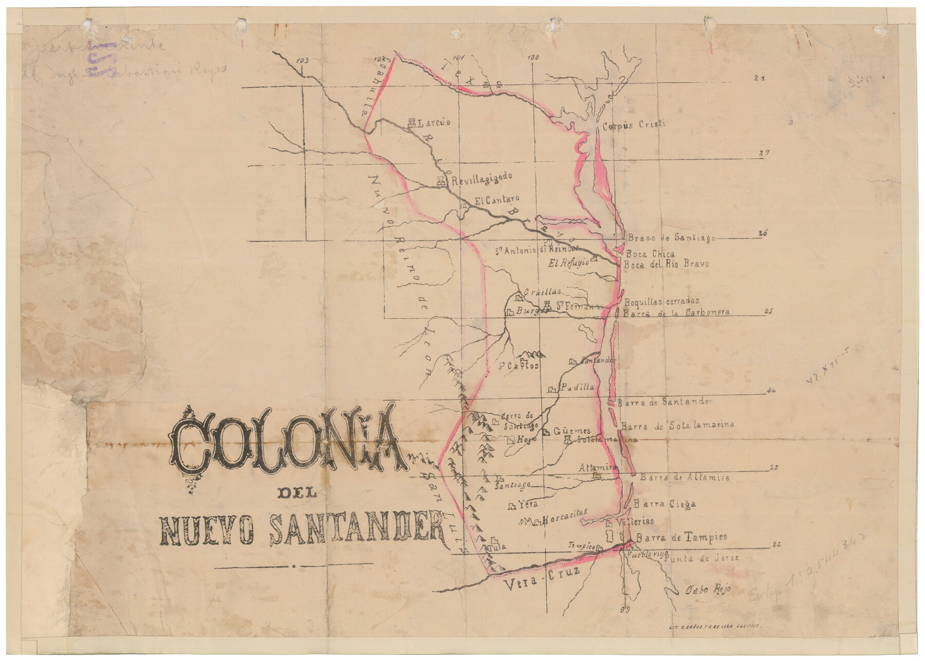
Colonia del Nuevo Santander
-
Map/Doc
94557
-
Collection
Non-GLO Digital Images
-
Object Dates
[1889] (Creation Date)
-
People and Organizations
[Alberto Gómez Llata] (Author)
-
Subjects
Mexico
-
Height x Width
13.6 x 19.0 inches
34.5 x 48.3 cm
-
Medium
digital image
-
Comments
Courtesy of the Mapoteca “Orozco y Berra” del Servicio de Información Agroalimentaria y Pesquera.
Reference: 722-OYB-7211-A
Not available for duplication - for research purposes only.
Part of: Non-GLO Digital Images
Bird's Eye View of the City of Dallas, Texas

Print $20.00
Bird's Eye View of the City of Dallas, Texas
1872
Size 18.6 x 25.6 inches
Map/Doc 89080
Bird's Eye View of New Braunfels, Comal County, Texas

Print $20.00
Bird's Eye View of New Braunfels, Comal County, Texas
1881
Size 17.0 x 24.1 inches
Map/Doc 89200
Greenville, Tex., County Seat of Hunt County

Print $20.00
Greenville, Tex., County Seat of Hunt County
1886
Size 17.3 x 24.9 inches
Map/Doc 89089
[WWI Topographic Planning Map of the Ardennes department] - Verso
![94130, [WWI Topographic Planning Map of the Ardennes department] - Verso, Non-GLO Digital Images](https://historictexasmaps.com/wmedia_w700/maps/94130-1.tif.jpg)
Print $20.00
[WWI Topographic Planning Map of the Ardennes department] - Verso
1918
Size 35.9 x 20.4 inches
Map/Doc 94130
El Nuevo México y Tierras Adyacentes Levantado para la Demarcación de los Límites de los Dominios Españoles y de los Estados Unidos

El Nuevo México y Tierras Adyacentes Levantado para la Demarcación de los Límites de los Dominios Españoles y de los Estados Unidos
1811
Size 9.4 x 12.6 inches
Map/Doc 94445
Outline of the Geology of the Globe

Print $20.00
Outline of the Geology of the Globe
1853
Size 19.3 x 23.6 inches
Map/Doc 95282
Texas Map Co's Map of Navarro County

Print $20.00
Texas Map Co's Map of Navarro County
1901
Size 31.3 x 36.3 inches
Map/Doc 96625
[Movements & Objectives of the 143rd & 144th Infantry on October 12-13, 1918, Appendix E, No.1]
![94126, [Movements & Objectives of the 143rd & 144th Infantry on October 12-13, 1918, Appendix E, No.1], Non-GLO Digital Images](https://historictexasmaps.com/wmedia_w700/maps/94126-1.tif.jpg)
Print $20.00
[Movements & Objectives of the 143rd & 144th Infantry on October 12-13, 1918, Appendix E, No.1]
1918
Size 22.5 x 20.0 inches
Map/Doc 94126

Map of Texas and the Countries Adjacent

Map of Texas and the Countries Adjacent
1844
Size 19.0 x 29.6 inches
Map/Doc 94561
Plano de la Villa y Presidio de S. Antonio de Vejar situado en la Provincia de Tejas en 29 grad. y 52 minutos de latitud bor. y 275° y 57' de long. contados desde de Meridiano d. Tenerife

Plano de la Villa y Presidio de S. Antonio de Vejar situado en la Provincia de Tejas en 29 grad. y 52 minutos de latitud bor. y 275° y 57' de long. contados desde de Meridiano d. Tenerife
1768
Size 16.8 x 21.2 inches
Map/Doc 96564
Map of New York and Adjacent Cities

Print $20.00
- Digital $50.00
Map of New York and Adjacent Cities
1860
Size 17.8 x 28.7 inches
Map/Doc 94439
You may also like
Presidio County Sketch File 98

Print $44.00
- Digital $50.00
Presidio County Sketch File 98
1955
Size 11.3 x 8.8 inches
Map/Doc 34783
Borden County Sketch File 10a

Print $40.00
- Digital $50.00
Borden County Sketch File 10a
Size 21.0 x 37.5 inches
Map/Doc 10935
[Blk. B, part of Blk. M, and north line of Morris County School Land]
![90359, [Blk. B, part of Blk. M, and north line of Morris County School Land], Twichell Survey Records](https://historictexasmaps.com/wmedia_w700/maps/90359-1.tif.jpg)
Print $20.00
- Digital $50.00
[Blk. B, part of Blk. M, and north line of Morris County School Land]
Size 23.9 x 22.7 inches
Map/Doc 90359
Hutchinson County

Print $20.00
- Digital $50.00
Hutchinson County
1922
Size 14.6 x 17.6 inches
Map/Doc 91183
[Part of North line of County, North of Block G]
![90805, [Part of North line of County, North of Block G], Twichell Survey Records](https://historictexasmaps.com/wmedia_w700/maps/90805-1.tif.jpg)
Print $20.00
- Digital $50.00
[Part of North line of County, North of Block G]
Size 17.6 x 12.1 inches
Map/Doc 90805
Flight Mission No. CLL-1N, Frame 159, Willacy County

Print $20.00
- Digital $50.00
Flight Mission No. CLL-1N, Frame 159, Willacy County
1954
Size 18.4 x 22.2 inches
Map/Doc 87050
W. C. Baze Subdivision a part of Tracts 25, 26, 27 and 28, Ross Addition to City of Idalou, Lubbock Co.

Print $20.00
- Digital $50.00
W. C. Baze Subdivision a part of Tracts 25, 26, 27 and 28, Ross Addition to City of Idalou, Lubbock Co.
1955
Size 9.2 x 18.9 inches
Map/Doc 92761
Starr County Rolled Sketch 32

Print $20.00
- Digital $50.00
Starr County Rolled Sketch 32
1942
Size 23.6 x 23.6 inches
Map/Doc 7829
Duval County Sketch File 66

Print $12.00
- Digital $50.00
Duval County Sketch File 66
1944
Size 14.5 x 8.8 inches
Map/Doc 21444
Map of Located Land of Gulf, Colorado & Santa Fe Ry. Co. through Denton

Print $40.00
- Digital $50.00
Map of Located Land of Gulf, Colorado & Santa Fe Ry. Co. through Denton
Size 55.5 x 25.8 inches
Map/Doc 64341
Martha's Vineyard to Block Island Including Western Approach to Cape Cod Canal

Print $20.00
- Digital $50.00
Martha's Vineyard to Block Island Including Western Approach to Cape Cod Canal
1963
Size 51.1 x 36.9 inches
Map/Doc 73555
Map of Espiritu Santo Bay in Calhoun County showing subdivision therof for mineral development

Print $20.00
- Digital $50.00
Map of Espiritu Santo Bay in Calhoun County showing subdivision therof for mineral development
1938
Size 38.6 x 42.9 inches
Map/Doc 2499