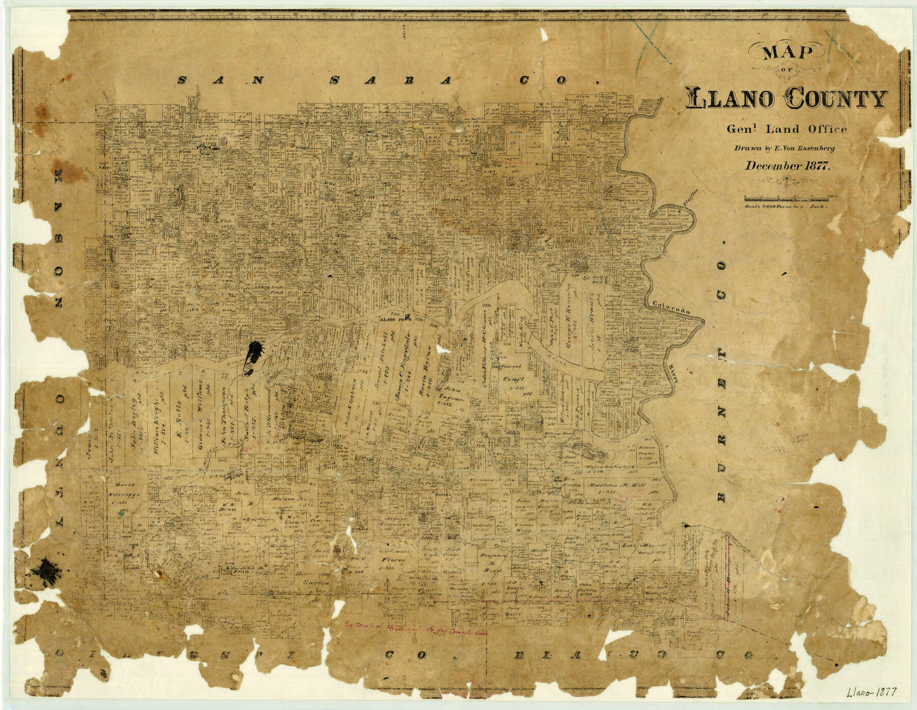
Map of Llano County
- 
                          Map/Doc3824
- 
                            CollectionGeneral Map Collection
- 
                            Object Dates1877 (Creation Date)
- 
                            People and OrganizationsTexas General Land Office (Publisher)E. von Rosenberg (Draftsman)
- 
                            CountiesLlano
- 
                            SubjectsCounty
- 
                            Height x Width19.9 x 25.7 inches50.5 x 65.3 cm
- 
                            FeaturesHondo CreekOak CreekHickory CreekBullhead CreekMarshall's CreekSandy CreekCrab Apple CreekSilvershire CreekEnchanted RockSharp MountainCoal CreekCommanche [sp] CreekPot CreekWalnut CreekPecan CreekSlick Rock CreekClear CreekWolf CreekMiller's CreekTrout CreekSnoozing Lion MountainCeirdri CreekCouncil Ground TrailMagill's CreekFalls CreekBlufftonColorado RiverLlano TownLittle Llano RiverBaby Head MountainJohnson's CreekFernando CreekField CreekLlano RiverElm CreekPack Saddle Mountain
Part of: General Map Collection
            Kimble County Sketch File 1


                                            Print $4.00                    
                                             -                         Digital $50.00                                    
                Kimble County Sketch File 1
1854
Size 7.2 x 10.0 inches
                                Map/Doc 28907
            
            Wilbarger County Working Sketch 16


                                            Print $20.00                    
                                             -                         Digital $50.00                                    
                Wilbarger County Working Sketch 16
1955
Size 32.7 x 19.9 inches
                                Map/Doc 72554
            
            Stephens County


                                            Print $20.00                    
                                             -                         Digital $50.00                                    
                Stephens County
1940
Size 42.9 x 41.0 inches
                                Map/Doc 63045
            
            Cherokee County


                                            Print $40.00                    
                                             -                         Digital $50.00                                    
                Cherokee County
1933
Size 57.0 x 38.8 inches
                                Map/Doc 77236
            
            La Salle County Working Sketch 48


                                            Print $20.00                    
                                             -                         Digital $50.00                                    
                La Salle County Working Sketch 48
1983
Size 26.2 x 36.0 inches
                                Map/Doc 70349
            
            Rains County Working Sketch 3


                                            Print $20.00                    
                                             -                         Digital $50.00                                    
                Rains County Working Sketch 3
1918
Size 22.3 x 12.5 inches
                                Map/Doc 71829
            
            Refugio County Aerial Photograph Index Sheet 5


                                            Print $20.00                    
                                             -                         Digital $50.00                                    
                Refugio County Aerial Photograph Index Sheet 5
1957
Size 23.2 x 18.9 inches
                                Map/Doc 83743
            
            Harris County Working Sketch 89


                                            Print $20.00                    
                                             -                         Digital $50.00                                    
                Harris County Working Sketch 89
1972
Size 37.3 x 39.0 inches
                                Map/Doc 65981
            
            Brewster County Sketch File NS-4c


                                            Print $6.00                    
                                             -                         Digital $50.00                                    
                Brewster County Sketch File NS-4c
Size 9.2 x 7.3 inches
                                Map/Doc 15958
            
            Caddo Lake Subdivision, Copied from Sketch in MF 000964


                                            Print $20.00                    
                                             -                         Digital $50.00                                    
                Caddo Lake Subdivision, Copied from Sketch in MF 000964
1918
Size 32.5 x 28.0 inches
                                Map/Doc 1929
            
            Midland County Working Sketch 20


                                            Print $20.00                    
                                             -                         Digital $50.00                                    
                Midland County Working Sketch 20
1953
Size 22.0 x 14.9 inches
                                Map/Doc 71001
            You may also like
            Maps of Gulf Intracoastal Waterway, Texas - Sabine River to the Rio Grande and connecting waterways including ship channels


                                            Print $20.00                    
                                             -                         Digital $50.00                                    
                Maps of Gulf Intracoastal Waterway, Texas - Sabine River to the Rio Grande and connecting waterways including ship channels
1966
Size 14.6 x 22.3 inches
                                Map/Doc 61956
            
            Southern Part of Laguna Madre


                                            Print $20.00                    
                                             -                         Digital $50.00                                    
                Southern Part of Laguna Madre
1960
Size 44.1 x 34.6 inches
                                Map/Doc 73538
            
            [George Tenille Grant, Brazoria County, Texas]
            
                                    ![10751, [George Tenille Grant, Brazoria County, Texas], Maddox Collection](https://historictexasmaps.com/wmedia_w700/maps/10751.tif.jpg) 


    ![10751, [George Tenille Grant, Brazoria County, Texas], Maddox Collection](https://historictexasmaps.com/wmedia_w700/maps/10751.tif.jpg) 
                                
            
                                            Print $2.00                    
                                             -                         Digital $50.00                                    
                [George Tenille Grant, Brazoria County, Texas]
Size 11.2 x 9.2 inches
                                Map/Doc 10751
            
            Throckmorton County Boundary File 3


                                            Print $40.00                    
                                             -                         Digital $50.00                                    
                Throckmorton County Boundary File 3
Size 18.9 x 17.9 inches
                                Map/Doc 59281
            
            Brown County Working Sketch 2


                                            Print $20.00                    
                                             -                         Digital $50.00                                    
                Brown County Working Sketch 2
1919
Size 17.0 x 17.5 inches
                                Map/Doc 67767
            
            Map of North America


                                            Print $20.00                    
                                             -                         Digital $50.00                                    
                Map of North America
1720
Size 25.0 x 39.6 inches
                                Map/Doc 93823
            
            Sterling County Working Sketch 2


                                            Print $20.00                    
                                             -                         Digital $50.00                                    
                Sterling County Working Sketch 2
1941
Size 19.9 x 26.2 inches
                                Map/Doc 63984
            
            Culberson County Working Sketch 52


                                            Print $20.00                    
                                             -                         Digital $50.00                                    
                Culberson County Working Sketch 52
1972
Size 37.3 x 39.5 inches
                                Map/Doc 68506
            
            Atascosa County Sketch File 23


                                            Print $40.00                    
                                             -                         Digital $50.00                                    
                Atascosa County Sketch File 23
Size 17.1 x 21.2 inches
                                Map/Doc 10860
            
            Block M6 in Castro, Swisher, and Randall Co's, Tex.


                                            Print $20.00                    
                                             -                         Digital $50.00                                    
                Block M6 in Castro, Swisher, and Randall Co's, Tex.
Size 13.8 x 17.2 inches
                                Map/Doc 90397
            
            Map of Glasscock County


                                            Print $20.00                    
                                             -                         Digital $50.00                                    
                Map of Glasscock County
Size 18.9 x 23.2 inches
                                Map/Doc 90711
             
                         
                                