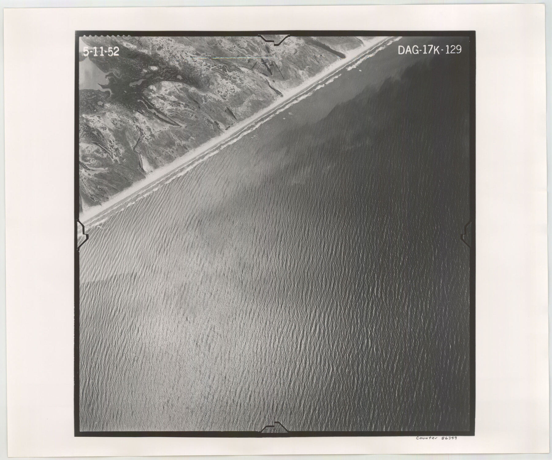
Flight Mission No. DAG-17K, Frame 129, Matagorda County
DAG-17K-129
-
Map/Doc
86349
-
Collection
General Map Collection
-
Object Dates
1952/5/11 (Creation Date)
-
People and Organizations
U. S. Department of Agriculture (Publisher)
-
Counties
Matagorda
-
Subjects
Aerial Photograph
-
Height x Width
18.6 x 22.3 inches
47.2 x 56.6 cm
-
Comments
Flown by Aero Exploration Company of Tulsa, Oklahoma.
Part of: General Map Collection
North Part of Brewster Co.

Print $20.00
- Digital $50.00
North Part of Brewster Co.
1956
Size 40.0 x 37.9 inches
Map/Doc 77220
Travis County Working Sketch 64

Print $20.00
- Digital $50.00
Travis County Working Sketch 64
2000
Size 16.8 x 19.6 inches
Map/Doc 69448
McMullen County

Print $20.00
- Digital $50.00
McMullen County
1967
Size 40.7 x 27.8 inches
Map/Doc 77363
Angelina County Working Sketch 23

Print $20.00
- Digital $50.00
Angelina County Working Sketch 23
1953
Size 19.8 x 32.6 inches
Map/Doc 67105
Flight Mission No. CRC-4R, Frame 71, Chambers County

Print $20.00
- Digital $50.00
Flight Mission No. CRC-4R, Frame 71, Chambers County
1956
Size 18.7 x 22.5 inches
Map/Doc 84875
Shackelford County Boundary File 7

Print $74.00
- Digital $50.00
Shackelford County Boundary File 7
Size 11.6 x 8.9 inches
Map/Doc 58671
Val Verde County Working Sketch 63

Print $20.00
- Digital $50.00
Val Verde County Working Sketch 63
1959
Size 23.2 x 32.1 inches
Map/Doc 72198
Val Verde County Rolled Sketch JR

Print $20.00
- Digital $50.00
Val Verde County Rolled Sketch JR
1938
Size 35.9 x 31.1 inches
Map/Doc 10080
Map of New Brunswick and Nova Scotia / Map of Newfoundland / Map of the West Indies, Guatimala and part of Mexico to illustrate Olney's school geography

Print $20.00
- Digital $50.00
Map of New Brunswick and Nova Scotia / Map of Newfoundland / Map of the West Indies, Guatimala and part of Mexico to illustrate Olney's school geography
1844
Size 9.5 x 12.1 inches
Map/Doc 93544
Bandera County Working Sketch 27

Print $20.00
- Digital $50.00
Bandera County Working Sketch 27
1950
Size 15.0 x 17.1 inches
Map/Doc 67623
Topographical Map of the Rio Grande, Sheet No. 12

Print $20.00
- Digital $50.00
Topographical Map of the Rio Grande, Sheet No. 12
1912
Map/Doc 89536
Montgomery County Rolled Sketch 27

Print $20.00
- Digital $50.00
Montgomery County Rolled Sketch 27
Size 34.5 x 34.4 inches
Map/Doc 9536
You may also like
Freestone County

Print $40.00
- Digital $50.00
Freestone County
1918
Size 48.4 x 41.6 inches
Map/Doc 66830

Hudspeth County Sketch File 34

Print $12.00
- Digital $50.00
Hudspeth County Sketch File 34
1944
Size 11.2 x 8.8 inches
Map/Doc 26997
Overlay For Flight Mission No. BRE-2P, Frame 110 of H. A. Pierce Corrected Survey, December 21, 1950 of Cyrus Egery Survey of June 15, 1855

Print $20.00
- Digital $50.00
Overlay For Flight Mission No. BRE-2P, Frame 110 of H. A. Pierce Corrected Survey, December 21, 1950 of Cyrus Egery Survey of June 15, 1855
1956
Size 18.3 x 20.4 inches
Map/Doc 86795
[North and West Line of Gray County, North Line of Wheeler County]
![89943, [North and West Line of Gray County, North Line of Wheeler County], Twichell Survey Records](https://historictexasmaps.com/wmedia_w700/maps/89943-1.tif.jpg)
Print $40.00
- Digital $50.00
[North and West Line of Gray County, North Line of Wheeler County]
Size 43.4 x 71.6 inches
Map/Doc 89943
Controlled Mosaic by Jack Amman Photogrammetric Engineers, Inc - Sheet 29

Print $20.00
- Digital $50.00
Controlled Mosaic by Jack Amman Photogrammetric Engineers, Inc - Sheet 29
1954
Size 20.0 x 24.0 inches
Map/Doc 83482
McMullen County Sketch File 5

Print $4.00
- Digital $50.00
McMullen County Sketch File 5
1854
Size 8.7 x 8.3 inches
Map/Doc 31343
[Surveys on Trespalacios Bay]
![19, [Surveys on Trespalacios Bay], General Map Collection](https://historictexasmaps.com/wmedia_w700/maps/19.tif.jpg)
Print $2.00
- Digital $50.00
[Surveys on Trespalacios Bay]
Size 7.2 x 9.6 inches
Map/Doc 19
Hardin County Rolled Sketch 17

Print $20.00
- Digital $50.00
Hardin County Rolled Sketch 17
1951
Size 38.3 x 32.4 inches
Map/Doc 6087
Bastrop County Working Sketch 11

Print $20.00
- Digital $50.00
Bastrop County Working Sketch 11
1968
Size 31.2 x 25.1 inches
Map/Doc 67311
Current Miscellaneous File 102

Print $611.00
- Digital $50.00
Current Miscellaneous File 102
Size 11.5 x 7.1 inches
Map/Doc 74379
Andrews County Rolled Sketch 12

Print $40.00
- Digital $50.00
Andrews County Rolled Sketch 12
1933
Size 58.1 x 39.1 inches
Map/Doc 8390