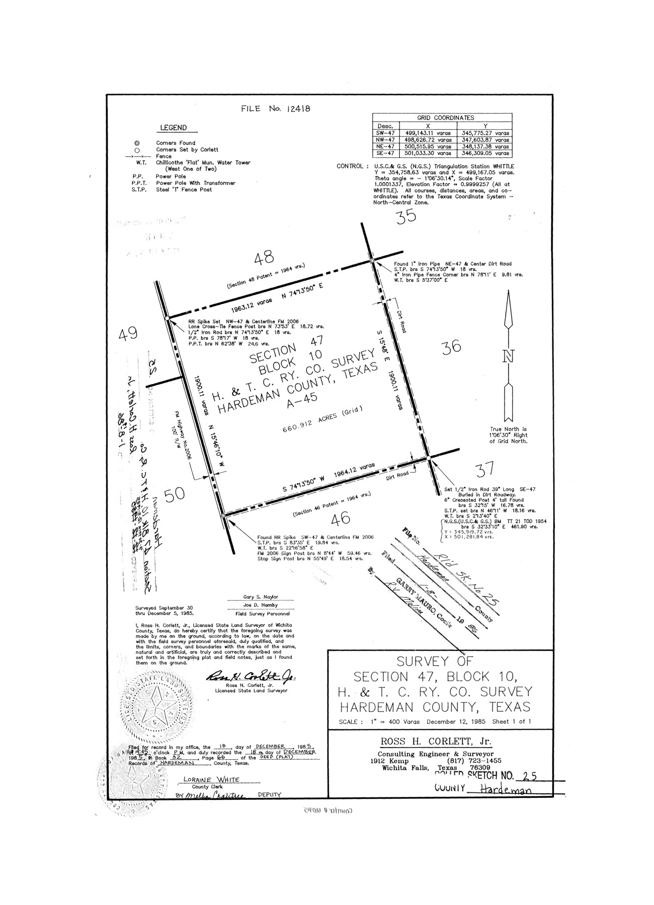
Hardeman County Rolled Sketch 25
Survey of section 47, Block 10, H. & T. C. Ry. Co. survey, Hardeman County, Texas
-
Map/Doc
6075
-
Collection
General Map Collection
-
Object Dates
1985/12/12 (Creation Date)
1986/1/8 (File Date)
1985/12/5 (Survey Date)
-
People and Organizations
Ross H. Corlett, Jr. (Surveyor/Engineer)
-
Counties
Hardeman
-
Subjects
Surveying Rolled Sketch
-
Height x Width
20.9 x 15.1 inches
53.1 x 38.4 cm
-
Medium
mylar, print
-
Scale
1" = 400 varas
Part of: General Map Collection
Winkler County Working Sketch 19

Print $20.00
- Digital $50.00
Winkler County Working Sketch 19
1990
Size 29.4 x 25.7 inches
Map/Doc 72613
Mitchell County Boundary File 66b

Print $15.00
- Digital $50.00
Mitchell County Boundary File 66b
Size 12.7 x 8.3 inches
Map/Doc 57383
Martin County Rolled Sketch 8

Print $20.00
- Digital $50.00
Martin County Rolled Sketch 8
Size 28.8 x 20.9 inches
Map/Doc 6668
Tom Green County Rolled Sketch 24

Print $20.00
- Digital $50.00
Tom Green County Rolled Sketch 24
Size 14.4 x 19.1 inches
Map/Doc 8006
Chart of Yellow Fever in the United States

Print $20.00
- Digital $50.00
Chart of Yellow Fever in the United States
1874
Size 16.3 x 17.2 inches
Map/Doc 95701
Bandera County Rolled Sketch 7

Print $20.00
- Digital $50.00
Bandera County Rolled Sketch 7
Size 42.7 x 29.0 inches
Map/Doc 5118
Starr County Rolled Sketch 38

Print $40.00
- Digital $50.00
Starr County Rolled Sketch 38
1944
Size 97.9 x 25.0 inches
Map/Doc 10297
[Plat of Texas and Pacific Railroad Company Block Lines, 80 Mile Reserve]
![3124, [Plat of Texas and Pacific Railroad Company Block Lines, 80 Mile Reserve], General Map Collection](https://historictexasmaps.com/wmedia_w700/maps/3124-1.tif.jpg)
Print $40.00
- Digital $50.00
[Plat of Texas and Pacific Railroad Company Block Lines, 80 Mile Reserve]
1876
Size 43.5 x 46.3 inches
Map/Doc 3124
La Salle County Working Sketch 52

Print $40.00
- Digital $50.00
La Salle County Working Sketch 52
1963
Size 53.5 x 43.0 inches
Map/Doc 70353
Lampasas County Sketch File A

Print $4.00
- Digital $50.00
Lampasas County Sketch File A
1887
Size 11.3 x 9.0 inches
Map/Doc 29383
Foard County Aerial Photograph Index Sheet 1

Print $20.00
- Digital $50.00
Foard County Aerial Photograph Index Sheet 1
1950
Size 19.2 x 17.2 inches
Map/Doc 83688
Montgomery County Rolled Sketch 33

Print $40.00
- Digital $50.00
Montgomery County Rolled Sketch 33
1953
Size 48.1 x 39.6 inches
Map/Doc 9541
You may also like
Rockwall County Working Sketch 4

Print $20.00
- Digital $50.00
Rockwall County Working Sketch 4
1966
Size 34.9 x 28.9 inches
Map/Doc 63596
George M. Slaughter Block Hockley and Cochran Counties, Texas

Print $20.00
- Digital $50.00
George M. Slaughter Block Hockley and Cochran Counties, Texas
1929
Size 14.1 x 25.2 inches
Map/Doc 92238
Fort Bend County State Real Property Sketch 9

Print $40.00
- Digital $50.00
Fort Bend County State Real Property Sketch 9
1986
Size 34.7 x 43.2 inches
Map/Doc 61683
Pecos County Rolled Sketch 19 1/2

Print $20.00
- Digital $50.00
Pecos County Rolled Sketch 19 1/2
1885
Size 41.9 x 17.6 inches
Map/Doc 7208
Cameron County Rolled Sketch 25

Print $20.00
- Digital $50.00
Cameron County Rolled Sketch 25
1977
Size 24.8 x 36.8 inches
Map/Doc 5792
Smith County Rolled Sketch 6E2

Print $20.00
- Digital $50.00
Smith County Rolled Sketch 6E2
1960
Size 27.6 x 22.7 inches
Map/Doc 10613
Current Miscellaneous File 43

Print $4.00
- Digital $50.00
Current Miscellaneous File 43
Size 11.2 x 8.7 inches
Map/Doc 73983
Greenville, Hunt County Texas

Print $20.00
Greenville, Hunt County Texas
1891
Size 16.4 x 30.0 inches
Map/Doc 89090
Kimble County Boundary File 2

Print $26.00
- Digital $50.00
Kimble County Boundary File 2
Size 9.6 x 6.2 inches
Map/Doc 64833
[Subdivision of Crockett County School Land Lgs. 214-217]
![90108, [Subdivision of Crockett County School Land Lgs. 214-217], Twichell Survey Records](https://historictexasmaps.com/wmedia_w700/maps/90108-1.tif.jpg)
Print $2.00
- Digital $50.00
[Subdivision of Crockett County School Land Lgs. 214-217]
Size 12.1 x 8.3 inches
Map/Doc 90108
Waller County Working Sketch Graphic Index

Print $20.00
- Digital $50.00
Waller County Working Sketch Graphic Index
1945
Size 46.7 x 27.2 inches
Map/Doc 76730
Parker County Sketch File 13

Print $4.00
- Digital $50.00
Parker County Sketch File 13
1860
Size 12.1 x 8.0 inches
Map/Doc 33546