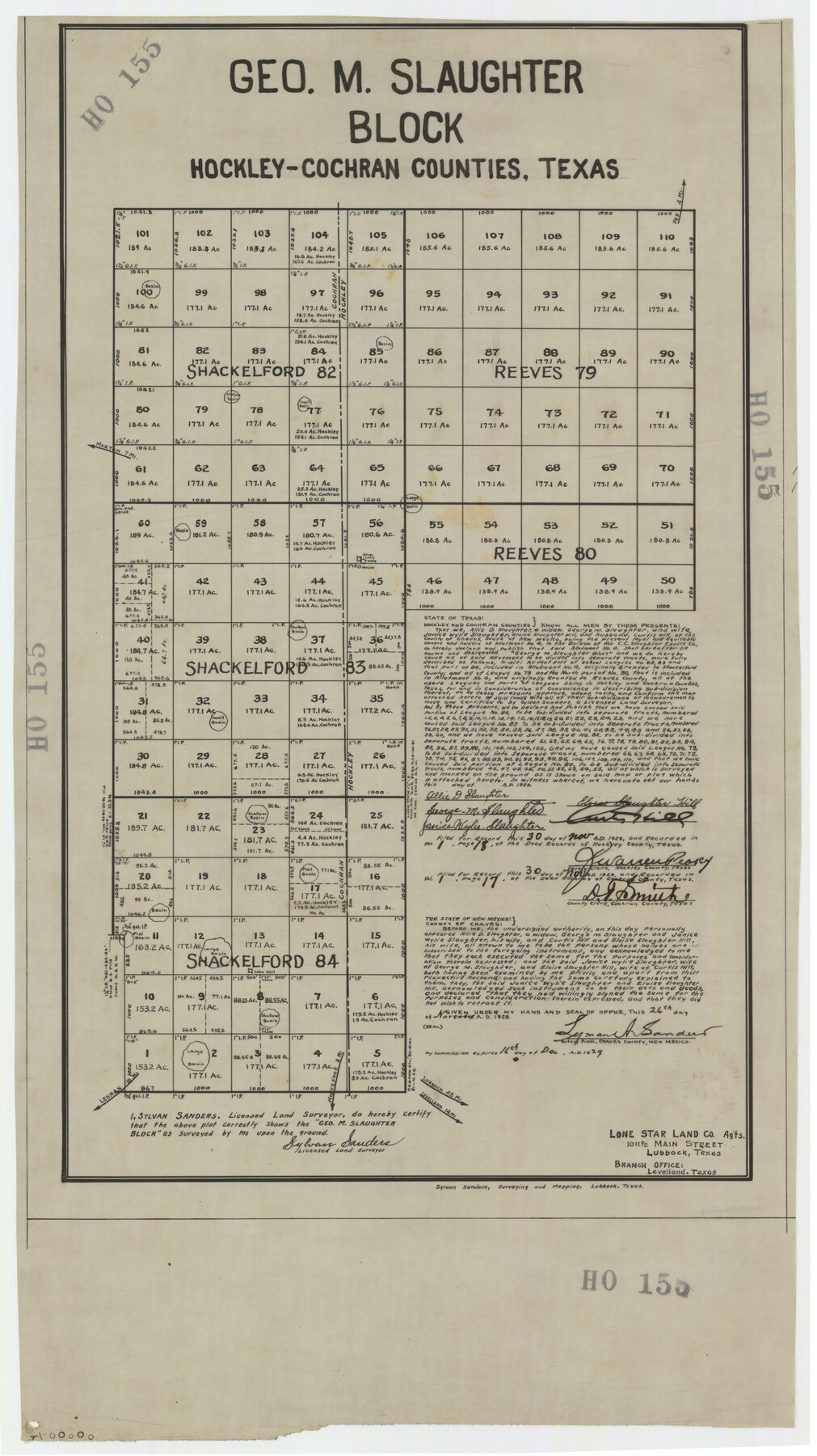
George M. Slaughter Block Hockley and Cochran Counties, Texas
HO155
-
Map/Doc
92238
-
Collection
Twichell Survey Records
-
Object Dates
1929 (Creation Date)
-
People and Organizations
Sylvan Sanders (Surveyor/Engineer)
-
Counties
Hockley Cochran
-
Height x Width
14.1 x 25.2 inches
35.8 x 64.0 cm
Part of: Twichell Survey Records
Working Sketch in Gray County

Print $3.00
- Digital $50.00
Working Sketch in Gray County
1903
Size 10.9 x 15.5 inches
Map/Doc 90753
[Strip between Block 8 and Block K4]
![90601, [Strip between Block 8 and Block K4], Twichell Survey Records](https://historictexasmaps.com/wmedia_w700/maps/90601-1.tif.jpg)
Print $2.00
- Digital $50.00
[Strip between Block 8 and Block K4]
Size 8.8 x 11.7 inches
Map/Doc 90601
[Block J and vicinity]
![91239, [Block J and vicinity], Twichell Survey Records](https://historictexasmaps.com/wmedia_w700/maps/91239-1.tif.jpg)
Print $20.00
- Digital $50.00
[Block J and vicinity]
Size 19.8 x 30.5 inches
Map/Doc 91239
![93119, [Capitol Lands], Twichell Survey Records](https://historictexasmaps.com/wmedia_w700/maps/93119-1.tif.jpg)
Subdivision Map of Fisher County School Land Situated in Bailey and Cochran Counties, Texas

Print $20.00
- Digital $50.00
Subdivision Map of Fisher County School Land Situated in Bailey and Cochran Counties, Texas
1924
Size 20.3 x 29.8 inches
Map/Doc 92472
[Sections 158-162 and surveys to the east]
![93003, [Sections 158-162 and surveys to the east], Twichell Survey Records](https://historictexasmaps.com/wmedia_w700/maps/93003-1.tif.jpg)
Print $20.00
- Digital $50.00
[Sections 158-162 and surveys to the east]
1916
Size 7.8 x 18.9 inches
Map/Doc 93003
Pecos County Sketch

Print $20.00
- Digital $50.00
Pecos County Sketch
Size 34.2 x 23.5 inches
Map/Doc 91642
[T. & P. Blocks 33 and 34, Townships 4N and 5N]
![90625, [T. & P. Blocks 33 and 34, Townships 4N and 5N], Twichell Survey Records](https://historictexasmaps.com/wmedia_w700/maps/90625-1.tif.jpg)
Print $20.00
- Digital $50.00
[T. & P. Blocks 33 and 34, Townships 4N and 5N]
Size 14.4 x 17.7 inches
Map/Doc 90625
Hockley County, Texas

Print $20.00
- Digital $50.00
Hockley County, Texas
Size 34.0 x 37.4 inches
Map/Doc 91200
[Blocks 11 and Z5]
![91716, [Blocks 11 and Z5], Twichell Survey Records](https://historictexasmaps.com/wmedia_w700/maps/91716-1.tif.jpg)
Print $3.00
- Digital $50.00
[Blocks 11 and Z5]
1903
Size 10.8 x 10.7 inches
Map/Doc 91716
[Part of Connected map of Stephen F. Austin's Colony on file at the GLO]
![90208, [Part of Connected map of Stephen F. Austin's Colony on file at the GLO], Twichell Survey Records](https://historictexasmaps.com/wmedia_w700/maps/90208-1.tif.jpg)
Print $20.00
- Digital $50.00
[Part of Connected map of Stephen F. Austin's Colony on file at the GLO]
1923
Size 18.8 x 18.2 inches
Map/Doc 90208
[Sketch of Norwood's Homestead]
![89646, [Sketch of Norwood's Homestead], Twichell Survey Records](https://historictexasmaps.com/wmedia_w700/maps/89646-1.tif.jpg)
Print $40.00
- Digital $50.00
[Sketch of Norwood's Homestead]
Size 31.8 x 49.7 inches
Map/Doc 89646
You may also like
Schleicher County Sketch File 30

Print $4.00
- Digital $50.00
Schleicher County Sketch File 30
1940
Size 11.3 x 8.8 inches
Map/Doc 36528
Martin County Working Sketch 10

Print $40.00
- Digital $50.00
Martin County Working Sketch 10
1971
Size 50.0 x 37.4 inches
Map/Doc 70828
Map of Oregon, Kansas, California, and the Territories

Print $20.00
- Digital $50.00
Map of Oregon, Kansas, California, and the Territories
1885
Size 9.0 x 12.2 inches
Map/Doc 93522
Pecos County Rolled Sketch 116

Print $20.00
- Digital $50.00
Pecos County Rolled Sketch 116
Size 26.7 x 20.6 inches
Map/Doc 7259
Red River County Sketch File 18

Print $2.00
- Digital $50.00
Red River County Sketch File 18
Size 5.5 x 7.9 inches
Map/Doc 35149
Brazos River Conservation and Reclamation District Official Boundary Line Survey, Parmer County

Print $20.00
- Digital $50.00
Brazos River Conservation and Reclamation District Official Boundary Line Survey, Parmer County
Size 24.6 x 16.8 inches
Map/Doc 91659
[Archer County School Land]
![90324, [Archer County School Land], Twichell Survey Records](https://historictexasmaps.com/wmedia_w700/maps/90324-1.tif.jpg)
Print $20.00
- Digital $50.00
[Archer County School Land]
Size 21.7 x 16.7 inches
Map/Doc 90324
General Highway Map, Andrews County, Texas

Print $20.00
General Highway Map, Andrews County, Texas
1961
Size 25.1 x 18.3 inches
Map/Doc 79347

Kinney County Sketch File 24

Print $6.00
- Digital $50.00
Kinney County Sketch File 24
1928
Size 14.2 x 8.8 inches
Map/Doc 29164
Lamb-Bailey County Line

Print $40.00
- Digital $50.00
Lamb-Bailey County Line
Size 15.1 x 52.6 inches
Map/Doc 89636
Edwards County Rolled Sketch 17

Print $20.00
- Digital $50.00
Edwards County Rolled Sketch 17
1945
Size 27.6 x 19.4 inches
Map/Doc 5806