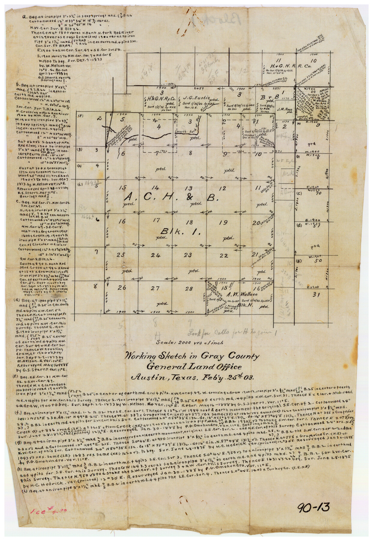
Working Sketch in Gray County
90-13
-
Map/Doc
90753
-
Collection
Twichell Survey Records
-
Object Dates
2/25/1903 (Creation Date)
-
Counties
Gray
-
Height x Width
10.9 x 15.5 inches
27.7 x 39.4 cm
Part of: Twichell Survey Records
C. B. Livestock Co.'s West-Ranch, Bailey County, Texas

Print $2.00
- Digital $50.00
C. B. Livestock Co.'s West-Ranch, Bailey County, Texas
Size 11.2 x 8.9 inches
Map/Doc 90381
[Area north of Leagues 1 & 4, Morris County School Land]
![90353, [Area north of Leagues 1 & 4, Morris County School Land], Twichell Survey Records](https://historictexasmaps.com/wmedia_w700/maps/90353-1.tif.jpg)
Print $20.00
- Digital $50.00
[Area north of Leagues 1 & 4, Morris County School Land]
Size 21.3 x 16.0 inches
Map/Doc 90353
West End Place Part of NW Quarter Section 44, Block AK

Print $20.00
- Digital $50.00
West End Place Part of NW Quarter Section 44, Block AK
Size 16.0 x 16.4 inches
Map/Doc 92346
North Line of Lynn County and South Line of Lubbock County

Print $20.00
- Digital $50.00
North Line of Lynn County and South Line of Lubbock County
1892
Size 8.0 x 34.2 inches
Map/Doc 91393
[Sketch showing Blocks B-11, G and M-2 and 3, L, and 47, Sections 77-102]
![91734, [Sketch showing Blocks B-11, G and M-2 and 3, L, and 47, Sections 77-102], Twichell Survey Records](https://historictexasmaps.com/wmedia_w700/maps/91734-1.tif.jpg)
Print $20.00
- Digital $50.00
[Sketch showing Blocks B-11, G and M-2 and 3, L, and 47, Sections 77-102]
Size 25.6 x 18.9 inches
Map/Doc 91734
Garden City Townsite, Section 5, Range 4 South, Block 33

Print $2.00
- Digital $50.00
Garden City Townsite, Section 5, Range 4 South, Block 33
1886
Size 9.0 x 15.4 inches
Map/Doc 90763
[Southeast Portion of Motley County]
![91508, [Southeast Portion of Motley County], Twichell Survey Records](https://historictexasmaps.com/wmedia_w700/maps/91508-1.tif.jpg)
Print $20.00
- Digital $50.00
[Southeast Portion of Motley County]
Size 31.2 x 34.3 inches
Map/Doc 91508
Bray Subdivision and McElroy Subdivision

Print $20.00
- Digital $50.00
Bray Subdivision and McElroy Subdivision
Size 19.3 x 25.2 inches
Map/Doc 92746
Deaf Smith County, Texas / [Sec. 144, Blk. K-5]
![92037, Deaf Smith County, Texas / [Sec. 144, Blk. K-5], Twichell Survey Records](https://historictexasmaps.com/wmedia_w700/maps/92037-1.tif.jpg)
Print $20.00
- Digital $50.00
Deaf Smith County, Texas / [Sec. 144, Blk. K-5]
Size 25.6 x 19.6 inches
Map/Doc 92037
Sketch in Lynn, Terry, Gaines and Dawson Counties

Print $40.00
- Digital $50.00
Sketch in Lynn, Terry, Gaines and Dawson Counties
1940
Size 53.2 x 33.1 inches
Map/Doc 92060
Map of Hale County, Texas

Print $2.00
- Digital $50.00
Map of Hale County, Texas
Size 8.8 x 11.2 inches
Map/Doc 90697
University Place - Addition

Print $20.00
- Digital $50.00
University Place - Addition
Size 20.2 x 12.0 inches
Map/Doc 92411
You may also like
Randall County Boundary File 4

Print $10.00
- Digital $50.00
Randall County Boundary File 4
Size 14.4 x 8.9 inches
Map/Doc 58129
Bosque County Working Sketch 27

Print $20.00
- Digital $50.00
Bosque County Working Sketch 27
2006
Size 29.8 x 38.0 inches
Map/Doc 85241
Trinity County Working Sketch 15

Print $20.00
- Digital $50.00
Trinity County Working Sketch 15
1974
Size 30.5 x 32.5 inches
Map/Doc 69464
Galveston County Rolled Sketch 43A

Print $20.00
- Digital $50.00
Galveston County Rolled Sketch 43A
Size 16.2 x 20.3 inches
Map/Doc 76005
Grayson County, Fannin District

Print $20.00
- Digital $50.00
Grayson County, Fannin District
1885
Size 39.6 x 35.1 inches
Map/Doc 81942
Flight Mission No. CUG-1P, Frame 52, Kleberg County

Print $20.00
- Digital $50.00
Flight Mission No. CUG-1P, Frame 52, Kleberg County
1956
Size 18.5 x 22.2 inches
Map/Doc 86130
Map of Lockhart, Caldwell Co., Texas

Print $20.00
- Digital $50.00
Map of Lockhart, Caldwell Co., Texas
1907
Size 30.5 x 38.9 inches
Map/Doc 4461
The Republic County of Fort Bend. January 28, 1841

Print $20.00
The Republic County of Fort Bend. January 28, 1841
2020
Size 14.7 x 21.6 inches
Map/Doc 96140
Stephen F. Austin Park

Print $20.00
- Digital $50.00
Stephen F. Austin Park
1950
Size 24.7 x 36.9 inches
Map/Doc 73568
Cass County Working Sketch 31

Print $20.00
- Digital $50.00
Cass County Working Sketch 31
1981
Size 30.7 x 31.1 inches
Map/Doc 67934
[Missouri, Kansas & Texas] E. L. & R. R. Railroad, Morris Co.
![64273, [Missouri, Kansas & Texas] E. L. & R. R. Railroad, Morris Co., General Map Collection](https://historictexasmaps.com/wmedia_w700/maps/64273.tif.jpg)
Print $20.00
- Digital $50.00
[Missouri, Kansas & Texas] E. L. & R. R. Railroad, Morris Co.
1906
Size 13.1 x 28.4 inches
Map/Doc 64273
Duval County Rolled Sketch EF

Print $20.00
- Digital $50.00
Duval County Rolled Sketch EF
1934
Size 26.8 x 35.0 inches
Map/Doc 5766