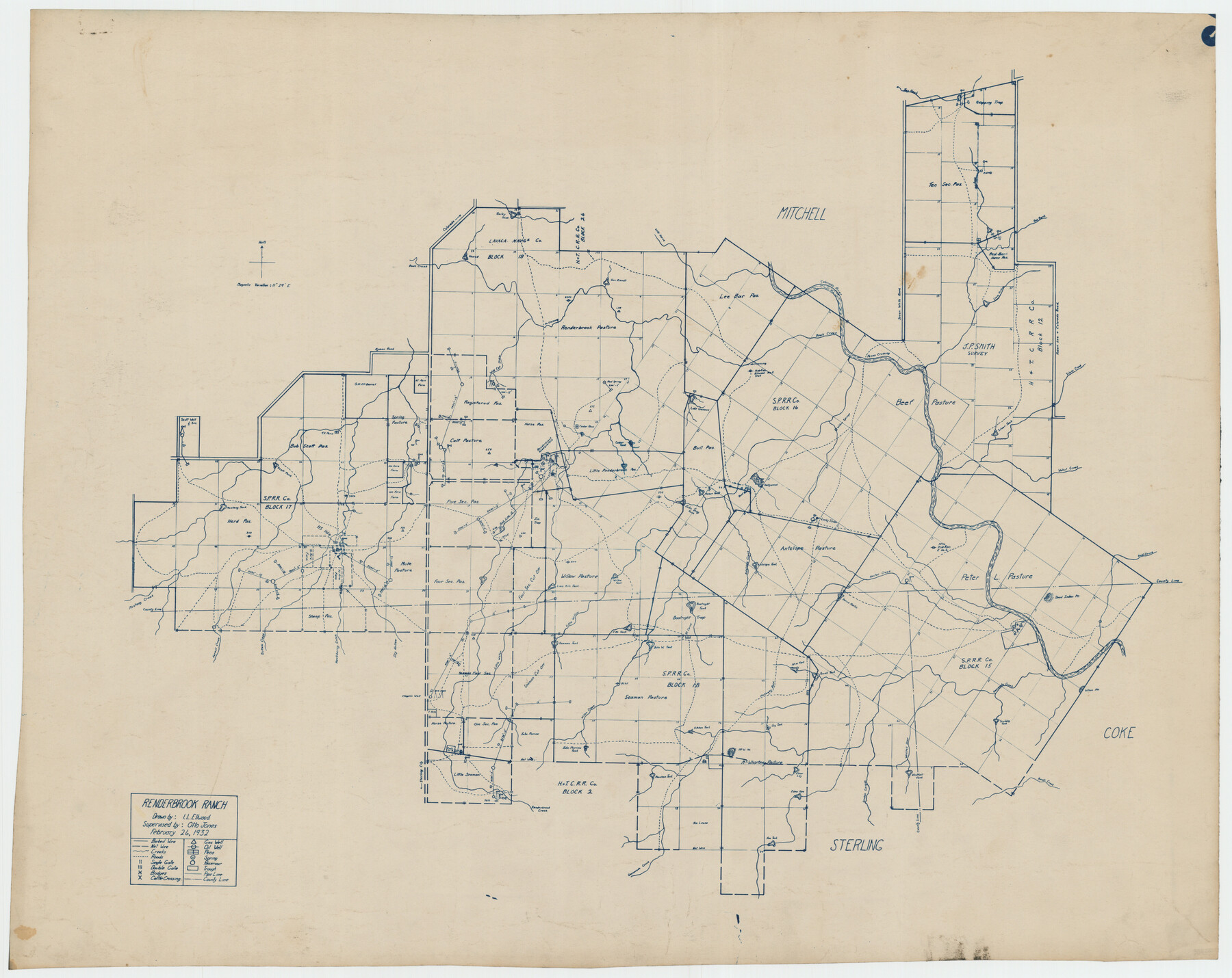
Renderbrook Ranch
-
Map/Doc
92279
-
Collection
Twichell Survey Records
-
Object Dates
2/26/1932 (Creation Date)
-
People and Organizations
Sylvan Sanders (Surveyor/Engineer)
B.T. Reeves (Surveyor/Engineer)
-
Counties
Mitchell Sterling Coke
-
Height x Width
16.9 x 13.5 inches
42.9 x 34.3 cm
Part of: Twichell Survey Records
[Midland County School Land, Martin County School Land, and vicinity]
![91128, [Midland County School Land, Martin County School Land, and vicinity], Twichell Survey Records](https://historictexasmaps.com/wmedia_w700/maps/91128-1.tif.jpg)
Print $2.00
- Digital $50.00
[Midland County School Land, Martin County School Land, and vicinity]
Size 9.0 x 11.4 inches
Map/Doc 91128
[Blocks in East Floyd County and West Motley County showing Blocks D2, D3, GM, GP and T]
![92113, [Blocks in East Floyd County and West Motley County showing Blocks D2, D3, GM, GP and T], Twichell Survey Records](https://historictexasmaps.com/wmedia_w700/maps/92113-1.tif.jpg)
Print $20.00
- Digital $50.00
[Blocks in East Floyd County and West Motley County showing Blocks D2, D3, GM, GP and T]
Size 22.2 x 10.9 inches
Map/Doc 92113
Map and Field Notes of D. & N. T. RR. Through E. L. Ellwood's Pasture

Print $20.00
- Digital $50.00
Map and Field Notes of D. & N. T. RR. Through E. L. Ellwood's Pasture
1912
Size 39.5 x 12.1 inches
Map/Doc 91003
Texas Boundary Line

Print $20.00
- Digital $50.00
Texas Boundary Line
Size 21.4 x 11.8 inches
Map/Doc 92076
[Blocks 36 and 37, Townships 1S-5S]
![93213, [Blocks 36 and 37, Townships 1S-5S], Twichell Survey Records](https://historictexasmaps.com/wmedia_w700/maps/93213-1.tif.jpg)
Print $40.00
- Digital $50.00
[Blocks 36 and 37, Townships 1S-5S]
Size 28.9 x 83.7 inches
Map/Doc 93213
Val Verde County, Texas, E. L. & R. R. Ry. Block D7 showing beginning point and direction of certain surveys

Print $20.00
- Digital $50.00
Val Verde County, Texas, E. L. & R. R. Ry. Block D7 showing beginning point and direction of certain surveys
1937
Size 22.1 x 17.0 inches
Map/Doc 91950
[Sketch showing area around Runnels County School Land, Yates survey 34 1/2 and Runnels County School Land]
![91681, [Sketch showing area around Runnels County School Land, Yates survey 34 1/2 and Runnels County School Land], Twichell Survey Records](https://historictexasmaps.com/wmedia_w700/maps/91681-1.tif.jpg)
Print $3.00
- Digital $50.00
[Sketch showing area around Runnels County School Land, Yates survey 34 1/2 and Runnels County School Land]
Size 15.8 x 9.7 inches
Map/Doc 91681
Map Showing Lands Surveyed by Sylvan Sanders in Block D, Yoakum County, Texas

Print $20.00
- Digital $50.00
Map Showing Lands Surveyed by Sylvan Sanders in Block D, Yoakum County, Texas
Size 28.6 x 24.4 inches
Map/Doc 92008
[Central Part of Hockley County]
![91192, [Central Part of Hockley County], Twichell Survey Records](https://historictexasmaps.com/wmedia_w700/maps/91192-1.tif.jpg)
Print $20.00
- Digital $50.00
[Central Part of Hockley County]
Size 34.6 x 21.0 inches
Map/Doc 91192
Original Town of Nadine, Lea County, New Mexico

Print $20.00
- Digital $50.00
Original Town of Nadine, Lea County, New Mexico
Size 27.1 x 33.5 inches
Map/Doc 92420
[Blk. 1 and League 3, Morris County School Land]
![90364, [Blk. 1 and League 3, Morris County School Land], Twichell Survey Records](https://historictexasmaps.com/wmedia_w700/maps/90364-1.tif.jpg)
Print $3.00
- Digital $50.00
[Blk. 1 and League 3, Morris County School Land]
Size 12.4 x 11.4 inches
Map/Doc 90364
[H. & T. C. 49, Part of G. C. & S. 35, Capitol Leagues 206, 207, 214, 215]
![90688, [H. & T. C. 49, Part of G. C. & S. 35, Capitol Leagues 206, 207, 214, 215], Twichell Survey Records](https://historictexasmaps.com/wmedia_w700/maps/90688-1.tif.jpg)
Print $20.00
- Digital $50.00
[H. & T. C. 49, Part of G. C. & S. 35, Capitol Leagues 206, 207, 214, 215]
1903
Size 13.1 x 13.2 inches
Map/Doc 90688
You may also like
Runnels County Working Sketch 17

Print $20.00
- Digital $50.00
Runnels County Working Sketch 17
1950
Size 27.1 x 21.5 inches
Map/Doc 63613

Bell County Sketch File 23

Print $4.00
- Digital $50.00
Bell County Sketch File 23
1873
Size 8.2 x 12.8 inches
Map/Doc 14414
Houston County Sketch File 23

Print $6.00
- Digital $50.00
Houston County Sketch File 23
1852
Size 6.5 x 5.2 inches
Map/Doc 26793
Mexico or New Spain in which the Motions of Cortes may be traced

Print $20.00
- Digital $50.00
Mexico or New Spain in which the Motions of Cortes may be traced
1795
Size 14.5 x 16.5 inches
Map/Doc 93650
Liberty County Sketch File 41

Print $2.00
- Digital $50.00
Liberty County Sketch File 41
1872
Size 12.5 x 8.5 inches
Map/Doc 29997
Grayson County Fannin District

Print $20.00
- Digital $50.00
Grayson County Fannin District
1885
Size 40.1 x 37.7 inches
Map/Doc 4961
Map of Wood County

Print $20.00
- Digital $50.00
Map of Wood County
1872
Size 15.6 x 16.8 inches
Map/Doc 4167
Flight Mission No. BRE-2P, Frame 34, Nueces County

Print $20.00
- Digital $50.00
Flight Mission No. BRE-2P, Frame 34, Nueces County
1956
Size 18.7 x 22.6 inches
Map/Doc 86736
Concho County Sketch File 50

Print $20.00
- Digital $50.00
Concho County Sketch File 50
1890
Size 15.9 x 13.6 inches
Map/Doc 19217
Outer Continental Shelf Leasing Map, Texas

Print $20.00
- Digital $50.00
Outer Continental Shelf Leasing Map, Texas
1954
Size 17.3 x 22.2 inches
Map/Doc 75832
The Republic County of Harrison. January 16, 1843

Print $20.00
The Republic County of Harrison. January 16, 1843
2020
Size 18.6 x 21.7 inches
Map/Doc 96174