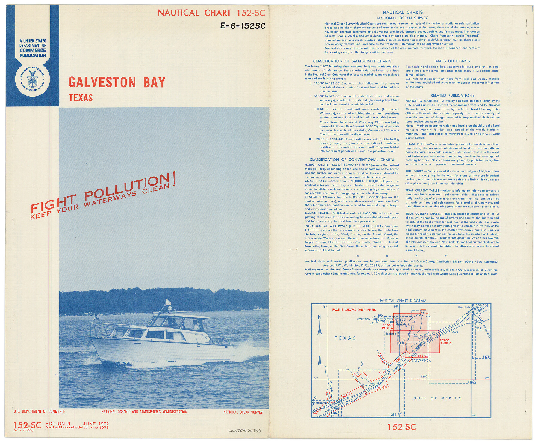
Nautical Chart 152-SC - Galveston Bay, Texas
-
Map/Doc
75908
-
Collection
General Map Collection
-
Object Dates
1972 (Creation Date)
-
Counties
Chambers Harris Galveston
-
Subjects
Nautical Charts
-
Height x Width
15.4 x 18.5 inches
39.1 x 47.0 cm
Part of: General Map Collection
Runnels County Sketch File 35

Print $20.00
Runnels County Sketch File 35
1889
Size 17.7 x 30.6 inches
Map/Doc 12266
A plat representing the survey and resubdivision of four tracts of land known as tracts no. 27, no. 26, no. 23, and no. 22, all of which are part of the Tara Subdivision, an unrecorded subdivision of 263.28 acres out of the J. M. Speer Subdivision

Print $6.00
- Digital $50.00
A plat representing the survey and resubdivision of four tracts of land known as tracts no. 27, no. 26, no. 23, and no. 22, all of which are part of the Tara Subdivision, an unrecorded subdivision of 263.28 acres out of the J. M. Speer Subdivision
1991
Size 24.7 x 34.3 inches
Map/Doc 3112
Uvalde County Working Sketch 2

Print $20.00
- Digital $50.00
Uvalde County Working Sketch 2
1911
Size 23.3 x 21.3 inches
Map/Doc 72072
Flight Mission No. DQN-6K, Frame 69, Calhoun County

Print $20.00
- Digital $50.00
Flight Mission No. DQN-6K, Frame 69, Calhoun County
1953
Size 18.6 x 22.1 inches
Map/Doc 84441
Andrews County Rolled Sketch 44

Print $40.00
- Digital $50.00
Andrews County Rolled Sketch 44
1990
Size 37.0 x 64.8 inches
Map/Doc 94990
Calhoun County Aerial Photograph Index Sheet 1

Print $20.00
- Digital $50.00
Calhoun County Aerial Photograph Index Sheet 1
1953
Size 23.7 x 19.7 inches
Map/Doc 83670
Wharton County

Print $20.00
- Digital $50.00
Wharton County
1877
Size 24.6 x 26.7 inches
Map/Doc 4133
Andrews County Sketch File 7

Print $6.00
- Digital $50.00
Andrews County Sketch File 7
1942
Size 11.2 x 8.8 inches
Map/Doc 12828
Concho County Rolled Sketch 21

Print $20.00
- Digital $50.00
Concho County Rolled Sketch 21
1969
Size 38.3 x 43.5 inches
Map/Doc 8666
Matagorda Light to Aransas Pass

Print $20.00
- Digital $50.00
Matagorda Light to Aransas Pass
1924
Size 35.9 x 44.6 inches
Map/Doc 73391
Kimble County Boundary File 3

Print $44.00
- Digital $50.00
Kimble County Boundary File 3
Size 9.8 x 32.4 inches
Map/Doc 64846
Presidio County Working Sketch 119

Print $20.00
- Digital $50.00
Presidio County Working Sketch 119
1983
Size 36.7 x 37.1 inches
Map/Doc 71796
You may also like
[H. & G. N. RR. Co. Block 1]
![90892, [H. & G. N. RR. Co. Block 1], Twichell Survey Records](https://historictexasmaps.com/wmedia_w700/maps/90892-1.tif.jpg)
Print $20.00
- Digital $50.00
[H. & G. N. RR. Co. Block 1]
1902
Size 14.9 x 15.8 inches
Map/Doc 90892
Montgomery County Sketch File 40

Print $8.00
- Digital $50.00
Montgomery County Sketch File 40
1914
Size 11.3 x 8.8 inches
Map/Doc 31925
[Public School Land Leagues]
![90445, [Public School Land Leagues], Twichell Survey Records](https://historictexasmaps.com/wmedia_w700/maps/90445-1.tif.jpg)
Print $3.00
- Digital $50.00
[Public School Land Leagues]
Size 11.8 x 15.8 inches
Map/Doc 90445
Hidalgo County Sketch

Print $20.00
- Digital $50.00
Hidalgo County Sketch
1903
Size 30.4 x 37.7 inches
Map/Doc 4450
Jackson County Rolled Sketch 15

Print $40.00
- Digital $50.00
Jackson County Rolled Sketch 15
1945
Size 53.7 x 30.3 inches
Map/Doc 9261
Carta Historica y Arqueologica

Print $20.00
- Digital $50.00
Carta Historica y Arqueologica
Size 26.0 x 34.4 inches
Map/Doc 96806

Limestone County Sketch File 22

Print $4.00
- Digital $50.00
Limestone County Sketch File 22
Size 11.4 x 7.3 inches
Map/Doc 30201
Taylor County Rolled Sketch 28

Print $20.00
- Digital $50.00
Taylor County Rolled Sketch 28
Size 34.4 x 23.9 inches
Map/Doc 7921
Map of Trinity Co.

Print $20.00
- Digital $50.00
Map of Trinity Co.
1896
Size 40.7 x 39.1 inches
Map/Doc 63079
Map of Young County

Print $20.00
- Digital $50.00
Map of Young County
1897
Size 44.1 x 37.9 inches
Map/Doc 63140
General Highway Map, Caldwell County, Texas

Print $20.00
General Highway Map, Caldwell County, Texas
1940
Size 18.5 x 25.2 inches
Map/Doc 79034