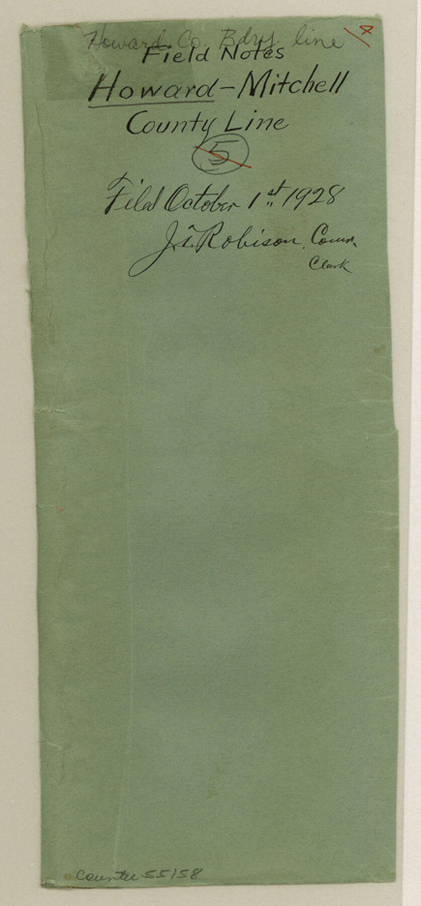
Howard County Boundary File 4
Field Notes Howard-Mitchell County Line
-
Map/Doc
55158
-
Collection
General Map Collection
-
Counties
Howard
-
Subjects
County Boundaries
-
Height x Width
9.4 x 4.3 inches
23.9 x 10.9 cm
Part of: General Map Collection
Kleberg County NRC Article 33.136 Sketch 1

Print $143.00
- Digital $50.00
Kleberg County NRC Article 33.136 Sketch 1
2000
Size 18.5 x 23.6 inches
Map/Doc 6555
Real County Sketch File 10

Print $6.00
- Digital $50.00
Real County Sketch File 10
1932
Size 10.3 x 15.0 inches
Map/Doc 35063
Polk County Sketch File 14

Print $6.00
- Digital $50.00
Polk County Sketch File 14
Size 5.7 x 11.4 inches
Map/Doc 34152
Colorado County Working Sketch 19

Print $20.00
- Digital $50.00
Colorado County Working Sketch 19
1958
Size 25.3 x 19.1 inches
Map/Doc 68119

Flight Mission No. DAG-24K, Frame 49, Matagorda County

Print $20.00
- Digital $50.00
Flight Mission No. DAG-24K, Frame 49, Matagorda County
1953
Size 18.5 x 22.2 inches
Map/Doc 86536
Bandera County Sketch File 29

Print $40.00
- Digital $50.00
Bandera County Sketch File 29
1939
Size 17.3 x 17.4 inches
Map/Doc 10898
Comanche County Sketch File 24 1/2

Print $6.00
- Digital $50.00
Comanche County Sketch File 24 1/2
Size 10.5 x 15.8 inches
Map/Doc 19113
Map of Bexar County

Print $40.00
- Digital $50.00
Map of Bexar County
1845
Size 48.8 x 43.0 inches
Map/Doc 87237
Jeff Davis County Rolled Sketch 28

Print $20.00
- Digital $50.00
Jeff Davis County Rolled Sketch 28
1977
Size 41.0 x 30.5 inches
Map/Doc 6376
[Surveys along Tehuacano and Grindstone Creek, drawings X and Y]
![299, [Surveys along Tehuacano and Grindstone Creek, drawings X and Y], General Map Collection](https://historictexasmaps.com/wmedia_w700/maps/299.tif.jpg)
Print $20.00
- Digital $50.00
[Surveys along Tehuacano and Grindstone Creek, drawings X and Y]
1846
Size 12.4 x 18.3 inches
Map/Doc 299
Chambers County Working Sketch 7

Print $20.00
- Digital $50.00
Chambers County Working Sketch 7
1939
Size 30.6 x 39.6 inches
Map/Doc 67990
You may also like
G. C. & S. F. Ry. Alinement [sic] and Right of Way Map of Dallas Branch, Johnson County, Texas
![64652, G. C. & S. F. Ry. Alinement [sic] and Right of Way Map of Dallas Branch, Johnson County, Texas, General Map Collection](https://historictexasmaps.com/wmedia_w700/maps/64652.tif.jpg)
Print $40.00
- Digital $50.00
G. C. & S. F. Ry. Alinement [sic] and Right of Way Map of Dallas Branch, Johnson County, Texas
1925
Size 37.6 x 87.9 inches
Map/Doc 64652
Orange County Sketch File 35

Print $22.00
- Digital $50.00
Orange County Sketch File 35
1929
Size 11.2 x 8.5 inches
Map/Doc 33363
Brewster County Rolled Sketch 145

Print $20.00
- Digital $50.00
Brewster County Rolled Sketch 145
1944
Size 24.1 x 18.5 inches
Map/Doc 5312
Pecos County Sketch File 91

Print $20.00
- Digital $50.00
Pecos County Sketch File 91
1951
Size 20.9 x 14.0 inches
Map/Doc 12184
Red River County Sketch File 8b

Print $6.00
- Digital $50.00
Red River County Sketch File 8b
1860
Size 8.2 x 3.7 inches
Map/Doc 35114
Glasscock County Rolled Sketch 15

Print $20.00
- Digital $50.00
Glasscock County Rolled Sketch 15
1964
Size 36.5 x 35.8 inches
Map/Doc 9059
Colorado River, Glen Flora Sheet

Print $6.00
- Digital $50.00
Colorado River, Glen Flora Sheet
1941
Size 24.5 x 32.6 inches
Map/Doc 65310
Map of Ellis County

Print $20.00
- Digital $50.00
Map of Ellis County
1871
Size 18.9 x 26.6 inches
Map/Doc 4493
[Sketch showing G. & M. Block 5]
![91704, [Sketch showing G. & M. Block 5], Twichell Survey Records](https://historictexasmaps.com/wmedia_w700/maps/91704-1.tif.jpg)
Print $2.00
- Digital $50.00
[Sketch showing G. & M. Block 5]
Size 7.5 x 5.8 inches
Map/Doc 91704
El Paso County Rolled Sketch 50

Print $40.00
- Digital $50.00
El Paso County Rolled Sketch 50
1956
Size 20.7 x 80.1 inches
Map/Doc 8876
Flight Mission No. CRE-3R, Frame 39, Jackson County

Print $20.00
- Digital $50.00
Flight Mission No. CRE-3R, Frame 39, Jackson County
1956
Size 18.6 x 22.2 inches
Map/Doc 85386
Carte d'une partie de L'Amérique Séptentrionale, qui contient partie de la Nle. Espagne, et de la Louisiane

Print $20.00
- Digital $50.00
Carte d'une partie de L'Amérique Séptentrionale, qui contient partie de la Nle. Espagne, et de la Louisiane
1782
Size 14.1 x 18.1 inches
Map/Doc 97118